
East Branch North Fork Feather River facts for kids
Quick facts for kids East Branch North Fork Feather River |
|
|---|---|

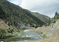
View of East Branch from SR 70
|
|
| Country | United States |
| State | California |
| Region | East Branch North Fork Feather Watershed |
| Physical characteristics | |
| River mouth | North Fork Feather River 2,274 ft (693 m) 40°00′51″N 121°13′32″W / 40.01417°N 121.22556°W |
| Length | 18.1 mi (29.1 km) |
| Basin features | |
| Basin size | 1,010 sq mi (2,600 km2) |
The East Branch North Fork Feather River is a river in California, United States. It's a smaller river that flows into the North Fork Feather River. This river is located in the northern part of the Sierra Nevada mountains, specifically in Plumas County, California. Much of its path goes through the Plumas National Forest. The river stretches from a place called Paxton (which is north of Quincy) all the way to Belden.
Contents
How the River Starts and Flows
Where Does the East Branch Begin?
The East Branch river starts when two other creeks, Indian Creek and Spanish Creek, join together. This meeting point is just a bit upstream from the town of Paxton.
The Journey of Indian and Spanish Creeks
Indian Creek and Spanish Creek collect water from a large area in eastern Plumas County. This area stretches for about 46 miles (74 km) along the Sierra Crest, which is the highest part of the Sierra Nevada mountains. Indian Creek is about 47 miles (76 km) long on its own. But if you measure it from the very start of its longest branch, Last Chance Creek, it's about 71 miles (114 km) long! Spanish Creek is a bit shorter, around 28 miles (45 km) long.
The River's Path to the North Fork
From where Indian and Spanish Creeks meet, the East Branch river flows west for about 18.1 miles (29.1 km). It winds its way through a deep and narrow canyon. Finally, it joins the North Fork Feather River near Belden. This spot is about 60 miles (97 km) northeast of Oroville.
Transportation Along the River
The canyon where the East Branch flows is very important for travel. State Route 70 (SR 70) is a highway that runs right alongside the north bank of the river. On the south bank, you'll find the Union Pacific Railroad's Feather River Route. This railway was built a long time ago, between 1906 and 1909. The highway was built later, in the 1920s.
Valleys Along the River's Path
There are some big, flat valleys in the area where the East Branch gets its water.
- Indian Valley: Indian Creek flows through this valley. Here, you'll find communities like Greenville and Taylorsville.
- American Valley: Spanish Creek flows through this valley. This is where Quincy is located, which is the main town of Plumas County.
Long ago, settlers changed these wet valleys to raise cattle and grow hay. They also made the stream channels deeper.
Images for kids
-
View of East Branch from SR 70
