Oroville, California facts for kids
Quick facts for kids
Oroville, California
|
||
|---|---|---|
| City of Oroville | ||
|
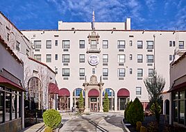
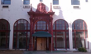
Oroville Inn
State Theatre
Downtown
|
||
|
||
| Nickname(s):
"City of Gold"
|
||
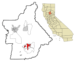
Location of Oroville in Butte County, California
|
||
| Country | United States | |
| State | California | |
| County | Butte | |
| Incorporated | January 3, 1906 | |
| Area | ||
| • City | 13.85 sq mi (35.9 km2) | |
| • Land | 13.83 sq mi (35.83 km2) | |
| • Water | 0.02 sq mi (0.05 km2) 0.14% | |
| Elevation | 167 ft (51 m) | |
| Population
(2020)
|
||
| • City | 20,042 | |
| • Density | 1,449.17/sq mi (559.36/km2) | |
| • Metro | 48,000 (estimated) | |
| Time zone | UTC-8 (PST) | |
| • Summer (DST) | UTC-7 (PDT) | |
| ZIP codes |
95940, 95965, 95966
|
|
| Area code(s) | Area code 530 | |
| FIPS code | 06-54386 | |
Oroville is a city in Butte County, California, United States. Its name comes from "Oro," which is Spanish for "Gold," and "Ville," which is French for "town."
In 2020, about 20,042 people lived there. After the 2018 Camp Fire, many people moved to Oroville. This fire destroyed much of the nearby town of Paradise.
Oroville is known as the entrance to Lake Oroville and the Feather River areas. These places are great for outdoor fun. The Berry Creek Rancheria of Maidu Indians of California also has its main office in Oroville.
The city is close to State Route 70 and State Route 99. These roads connect Oroville to other cities. Chico is about 23 miles (37 km) northwest. Sacramento, the state capital, is about 70 miles (113 km) south.
Oroville's nickname is the "City of Gold." This is like saying its Spanish name in English. The National Arbor Day Foundation has called Oroville a Tree City USA for over 40 years.
Contents
History of Oroville
Oroville is located at the bottom of the foothills. It sits on the banks of the Feather River. This is where the river flows from the Sierra Nevada mountains into the Sacramento Valley.
Gold Rush Days
The town started as a place to supply gold miners. This was during the California Gold Rush. Boats could travel up the Feather River to Oroville.
The town was first called "Ophir City." But its name changed to Oroville in 1854. That's when the first post office opened. The City of Oroville officially became a city on January 3, 1906.
Gold was found at Bidwell Bar. This was one of the first gold mining spots in California. Thousands of people came to the Oroville area looking for gold.
Today, Lake Oroville covers Bidwell Bar. The Bidwell Bar Bridge reminds us of this past. It was the first suspension bridge in California.
Railroads and Temples
In the early 1900s, the Western Pacific Railroad built a route. It went through the Feather River Canyon. This route was known as "The Feather River Route." Oroville was an important stop for the famous California Zephyr train.
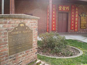
The Chinese Temple is another important historical site. Chinese workers built it in 1863. It was a place of worship for followers of different Chinese religions. Today, it has many old items and a peaceful garden.
Famous People and Places
Freda Ehmann started the olive-canning business in Oroville. She was called the "mother of ripe olives." By 1900, her factory was the biggest canned olive factory in the world.
Ishi was a very famous resident of Oroville. He was the last member of the Yahi Native American tribe. He came out of the wilderness in 1911. He was known as the last "Stone Age" Indian to join modern society. You can learn about Ishi at the Lake Oroville Visitor's Center.
Geography and Climate
Oroville is located where the Feather River becomes easy to travel by boat. The Yuba River joins the Feather River near Marysville, California. Both rivers then flow into the Sacramento River.
Oroville is where three different land types meet. To the west is the flat Central Valley. To the southeast are the Sierra Nevada mountains. To the north are the Cascade Mountains.
Oroville's Climate
Oroville has a warm-summer Mediterranean climate. This means it has hot, dry summers and mild, wet winters.
On average, Oroville gets about 30.7 inches (78 cm) of rain each year. This is a bit more than the average rainfall for California.
| Climate data for Oroville | |||||||||||||
|---|---|---|---|---|---|---|---|---|---|---|---|---|---|
| Month | Jan | Feb | Mar | Apr | May | Jun | Jul | Aug | Sep | Oct | Nov | Dec | Year |
| Record high °F (°C) | 82 (28) |
82 (28) |
88 (31) |
96 (36) |
104 (40) |
115 (46) |
115 (46) |
113 (45) |
108 (42) |
102 (39) |
90 (32) |
76 (24) |
115 (46) |
| Mean daily maximum °F (°C) | 55.1 (12.8) |
60.8 (16.0) |
65.3 (18.5) |
71.7 (22.1) |
80.8 (27.1) |
89.8 (32.1) |
96.4 (35.8) |
94.7 (34.8) |
89 (32) |
78.6 (25.9) |
64.7 (18.2) |
55.3 (12.9) |
75.2 (24.0) |
| Mean daily minimum °F (°C) | 37.2 (2.9) |
40.4 (4.7) |
43.4 (6.3) |
46.3 (7.9) |
52.2 (11.2) |
58.3 (14.6) |
62 (17) |
59.9 (15.5) |
55.6 (13.1) |
49 (9) |
42 (6) |
37.3 (2.9) |
48.6 (9.2) |
| Record low °F (°C) | 22 (−6) |
22 (−6) |
26 (−3) |
29 (−2) |
30 (−1) |
35 (2) |
45 (7) |
42 (6) |
40 (4) |
27 (−3) |
23 (−5) |
12 (−11) |
12 (−11) |
| Average precipitation inches (mm) | 5.55 (141) |
4.84 (123) |
4.05 (103) |
2.21 (56) |
1 (25) |
0.44 (11) |
0.04 (1.0) |
0.14 (3.6) |
0.4 (10) |
1.65 (42) |
3.57 (91) |
4.8 (120) |
28.69 (729) |
| Average snowfall inches (cm) | 0 (0) |
0 (0) |
0 (0) |
0 (0) |
0 (0) |
0 (0) |
0 (0) |
0 (0) |
0 (0) |
0 (0) |
0 (0) |
0 (0) |
0 (0) |
| Average precipitation days | 11 | 10 | 9 | 7 | 4 | 2 | 0 | 0 | 1 | 4 | 8 | 10 | 66 |
| Source: WRCC | |||||||||||||
Population and People
| Historical population | |||
|---|---|---|---|
| Census | Pop. | %± | |
| 1860 | 2,429 | — | |
| 1870 | 1,425 | −41.3% | |
| 1880 | 1,743 | 22.3% | |
| 1890 | 1,787 | 2.5% | |
| 1910 | 3,859 | — | |
| 1920 | 3,340 | −13.4% | |
| 1930 | 3,698 | 10.7% | |
| 1940 | 4,421 | 19.6% | |
| 1950 | 5,387 | 21.9% | |
| 1960 | 6,115 | 13.5% | |
| 1970 | 7,536 | 23.2% | |
| 1980 | 8,683 | 15.2% | |
| 1990 | 11,960 | 37.7% | |
| 2000 | 13,004 | 8.7% | |
| 2010 | 15,546 | 19.5% | |
| 2020 | 20,042 | 28.9% | |
| U.S. Decennial Census | |||
Population in 2010
In 2010, Oroville had a population of 15,546 people. Most residents were White (75.2%). Other groups included Asian (8.0%), Native American (3.7%), and African American (2.9%). About 12.5% of the people were Hispanic or Latino.
About 27.4% of the population was under 18 years old. The average age was 31.5 years.
Population in 2000
In 2000, the city's population was 13,004. The racial makeup was similar to 2010. The average household had 2.50 people.
Diverse Communities
Oroville is home to many different groups of people. A large number of Hmong live here. They came from Southeast Asia, especially Laos, after the Vietnam War. Many Hmong helped American forces during the war. They were given a safe place to live in the U.S. after 1975.
Every autumn, the Hmong community holds a New Year celebration. In 2010, over 700 Hmong people lived in Oroville.
A community of Romanians also moved to Oroville in the 1950s. In 2010, about 560 Romanians lived in the city.
Native Americans made up 3.7% of Oroville's population in 2010. The largest group is the local Maidu tribe. The Berry Creek Rancheria of Maidu Indians of California is based in Oroville. The world's largest museum of Maidu culture is nearby.
Economy and Jobs
Oroville's economy mostly depends on tourism. People visit Lake Oroville and the Feather River for fun. The biggest job areas in Oroville are healthcare, retail stores, and hotels/restaurants.
The nearby city of Chico is growing. This means more people are moving to Oroville. They come for lower housing costs and a cheaper cost of living. Oroville is also seeing more new businesses. Oroville Hospital is expanding, building a new five-story tower.
Main Employers
Here are some of the top employers in Oroville:
| # | Employer | # of Employees |
|---|---|---|
| 1 | County of Butte | 2,320 |
| 2 | Oroville Medical Complex | 1,650 |
| 3 | Pacific Coast Producers | 992 |
| 4 | Walmart Stores, Inc. | 289 |
| 5 | Graphic Packaging International | 205 |
| 5 | Walmart Stores, Inc. | 234 |
| 6 | Ammunition Accessories | 158 |
| 7 | Sierra Pacific Industries | 128 |
| 8 | Home Depot USA | 126 |
| 9 | City of Oroville | 111 |
| 10 | Roplast Industries, Inc | 93 |
| 11 | Currier Square Spe LLC | 67 |
Fun Things to Do (Tourism)
- The Oroville Dam is the tallest dam in the U.S. It is one of the 20 largest dams in the world. The dam is 770 feet (235 m) tall and 6,920 feet (2,109 m) long.
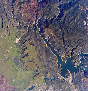
- Lake Oroville is a huge lake created by the dam. It is 900 feet (274 m) deep when full. The lake has 15,500 acres (6,273 ha) for fun activities. You can go camping, picnicking, hiking, boating, water-skiing, and fishing.
- The Lake Oroville Visitor Center has a museum. It tells the story of the dam and the State Water Project. There's a 47-foot (14 m) viewing tower for great views of the lake.
- The Mother Orange Tree in Oroville is the oldest orange tree in Northern California.
- The Feather River Fish Hatchery raises Chinook salmon and steelhead fish. The Oroville Salmon Festival happens every September.
- Riverbend Park is a 210-acre (85 ha) park on the Feather River. It has boat access, fishing, disc golf, and trails.
- The Brad Freeman Bike Trail is 41 miles (66 km) long. It runs along the Feather River and through the city.
- The Oroville Chinese Temple was built in 1863. It was a place of worship for Chinese immigrants.
Parks and Recreation
Oroville has many parks with playgrounds, picnic areas, and benches.
Parks and Trails to Explore
Parks
- Riverbend Park
- Bedrock Park
- The C.F. Lott Home in Sank Park – A historic home from 1856 with a beautiful garden.
- Hammon Park
- Hewitt Park
- Rotary Park
- Martin Luther King Jr. Park
- Playtown USA Park
- Gary Nolan Baseball Complex (Mitchell Field)
- Nelson Sports Complex
- Centennial Park
Trails
- Feather River Bike Trail
- Brad Freeman Trail
- Dan Beebe Trail
- North Table Mountain Ecological Reserve
- Kelly Ridge Recreation Area
Education in Oroville
The Oroville Union High School District serves the greater Oroville area. It includes two main high schools: Las Plumas High School and Oroville High School. Prospect High School helps students who need extra support. Oroville also has an adult school.
Elementary Schools
- Oakdale Heights Elementary
- Ophir Elementary
- Stanford Avenue Elementary
- Wyandotte Academy
- STREAM Charter School
- Helen Wilcox Elementary School
- Golden Hills Elementary
Middle Schools
- Central Middle School
- Ishi Hills Middle School
- Palermo Middle School
- Nelson Ave Middle School
High Schools
- Oroville High School
- Las Plumas High School
- Prospect High School
Higher Education
- Oroville Adult School
- California State University, Chico (in Chico, 24 miles (39 km) away)
- Butte Community College
- Northwest Lineman College
Media
Oroville has a local radio station called KOYO-LP. It is a low-power community radio station. Volunteers run it. It plays music, news, and community programs on 107.1 FM.
Transportation
You can travel to and from Oroville by bus. The Amtrak Thruway bus service connects Oroville to Sacramento and Stockton.
City Services (Infrastructure)
Hospital
Oroville Hospital is a general hospital in the city. It offers basic emergency care.
Fire Department
The Oroville Fire Department protects the city. It covers about 13 square miles (34 sq km).
Environmental Care Sites
Oroville has had some areas that needed special environmental care. These are called superfund sites. They were places where chemicals from past industrial activities were found. Two of these sites have been fully cleaned up.
- The Koppers Co. plant was listed in 1984. It had chemicals from wood treatment.
- The Louisiana-Pacific sawmill was listed in 1986. It also had chemicals from its operations. This site was cleaned up by 1996.
- The Western Pacific Railroad yard was listed in 1990. It had chemicals from train maintenance. This site was cleaned up by 2001.
Notable People
- Isaac Austin, professional basketball player
- Kevin Brown, professional baseball player
- Ishi, last surviving member of the Yahi Native American Tribe
- Doug LaMalfa, U.S. Representative
- Gary Nolan, professional baseball player
- John Spence, first American combat frogman
- Robert H. Young, Korean War Medal of Honor recipient
- Hubert Zemke, pilot
Sister Cities
 – Salem, Massachusetts (United States) 2007
See also
 In Spanish: Oroville (California) para niños
 | Frances Mary Albrier |
 | Whitney Young |
 | Muhammad Ali |


