
Salem, Massachusetts facts for kids
Quick facts for kids
Salem
|
|||
|---|---|---|---|
|
City
|
|||
|
|||
| Nickname(s):
The Witch City, The City of Witches, Pleasure City
|
|||
| Motto(s):
Divitis Indiae usque ad ultimum sinum (Latin: To the farthest port of the rich Indies)
|
|||

Location in Essex County, Massachusetts
|
|||

Salem
Location in the United States
|
|||
| Country | |||
| State | Massachusetts | ||
| County | Essex | ||
| Settled | 1626 | ||
| Incorporated | 1629 | ||
| City | 1836 | ||
| Founded by | Roger Conant | ||
| Government | |||
| • Type | Mayor-council city | ||
| Area | |||
| • Total | 18.30 sq mi (47.40 km2) | ||
| • Land | 8.29 sq mi (21.48 km2) | ||
| • Water | 10.01 sq mi (25.92 km2) | ||
| Elevation | 26 ft (8 m) | ||
| Population
(2020)
|
|||
| • Total | 44,480 | ||
| • Density | 5,362.91/sq mi (2,070.66/km2) | ||
| Time zone | UTC−5 (Eastern) | ||
| • Summer (DST) | UTC−4 (Eastern) | ||
| ZIP Code |
01970
|
||
| Area code(s) | 351, 978 | ||
| FIPS code | 25-59105 | ||
| GNIS feature ID | 0614337 | ||


_-_Salem,_Massachusetts.jpg)


Salem (/ˈseɪləm/ SAY-ləm) is a historic city on the coast of Massachusetts, in the United States. It is part of the North Shore area near Greater Boston. English colonists first settled here in 1626.
Salem was once a very important seaport for trading goods in early American history. Today, Salem is a popular place for people to live and visit. It is home to famous places like the House of Seven Gables, Salem State University, and the Peabody Essex Museum. The city had 44,480 people living there in 2020.
Salem is most famous for the Salem witch trials that happened in 1692. This event still shapes the city's identity today. For example, some police cars have witch logos. A local elementary school is called Witchcraft Heights. Also, the Salem High School sports teams are known as the Witches.
People used to think Gallows Hill was where the witch trial executions happened. But in 2016, a nearby place called Proctor's Ledge was found to be the real site. Gallows Hill is now a city park. Salem is also where the National Guard began in 1636, gathering at the Salem Common.
Contents
Exploring Salem's Past


Native American History: The Naumkeag People
Before Europeans arrived, Native Americans lived in this area for thousands of years. The land that became Salem was called Naumkeag by the native people. This was a main settlement for the group that lived between the Merrimack and Mystic rivers. The English called them the Naumkeag people.
The arrival of Europeans was very hard for the Naumkeag. Many died in a war with the Tarrantine people. A terrible smallpox epidemic in 1617–1619 also killed many, including their leader, Nanepashemet. This disease likely came from European fishermen or explorers.
Another smallpox outbreak in 1633 killed more leaders. This weakened the Naumkeag just before English settlers arrived in 1626. So, the English met little resistance when they settled in Salem. Later, in 1686, the Naumkeag's heirs were paid for their land in Salem.
English Colonists Arrive in Salem
English colonists first settled Naumkeag in 1626. They were fishermen from Cape Ann, led by Roger Conant. Conant's leadership helped the settlers survive the first two years.
However, John Endecott took over leadership in 1628. Conant agreed to step aside and was given land. To celebrate this peaceful change, the settlement's name was changed to Salem. This name comes from "Shalem," a word meaning "peace" in the Bible.
In 1628, Endecott moved a large house from Cape Ann to Salem. It was a two-story house, which was very impressive for the time. In 1629, the Massachusetts Bay Colony was officially created. John Winthrop became governor in 1629 and arrived with many new settlers in 1630. This was part of the Puritan Great Migration.
In 1639, Endecott helped sign the contract to build the first church in Salem. This church, the First Church of Salem, was the original Puritan church in America.
Salem's Role in Trade and Conflict

Salem's harbor was protected by forts, like Fort Pickering on Winter Island, from 1643 to 1865. During the 1600s and 1700s, Salem was involved in the Atlantic slave trade. However, by 1770, slavery was mostly ended in Massachusetts. Many enslaved people gained their freedom.
In 1768, Salem got its first newspaper, The Essex Gazette. This was the third newspaper in Massachusetts.
The Salem Witch Trials
Salem is most famous for its history of witchcraft accusations. These began in 1692 when some young girls started playing games. They used a mirror and an egg to try and see their future sweethearts.
The infamous Salem witch trials led to 19 people being executed by hanging. Giles Corey was pressed to death for refusing to say if he was innocent or guilty. This meant he died an innocent man.
John Hathorne was a judge during the witch trials. He became known as the "Hanging Judge" because he sentenced many accused witches to death.
Salem During the American Revolution
On February 26, 1775, a group of American patriots stopped British soldiers in Salem. They raised a bridge, preventing the British from taking hidden weapons. No one was hurt that day. But war broke out soon after at Lexington and Concord.
During the American Revolutionary War, Salem became a center for privateering. Privateers were private ships allowed to attack enemy ships. Nearly 800 privateer ships from Salem captured or destroyed about 600 British ships. This continued during the War of 1812.

Global Trade and Growth
After the American Revolution, Salem's ships began trading with faraway countries. In 1795, Captain Jonathan Carnes brought the first large cargo of pepper from Sumatra to Salem. This made a huge profit.
By 1790, Salem was one of the largest cities in the United States. It was a famous seaport, especially for trade with China. Salem ships also traded codfish with Europe and the West Indies. They brought back sugar and molasses from the West Indies, and tea from China. Salem ships also visited Africa, Russia, Japan, and Australia.
The Embargo Act of 1807 closed all U.S. ports. This was a big economic blow to Salem. This act was a step towards the War of 1812.

Salem became a city on March 23, 1836. Its city seal has a Latin motto meaning "To the farthest port of the rich Indies." Nathaniel Hawthorne, a famous author, worked at Salem's port from 1846 to 1849. His book The Scarlet Letter starts at the U.S. Custom House in Salem.
Shipping in Salem declined during the 1800s. Larger cities like Boston and New York took over. Salem's harbor also became silted up. So, the city turned to manufacturing, like tanneries and shoe factories.
The Great Salem Fire of 1914 destroyed over 400 homes. But it spared the beautiful Federal-style mansions on Chestnut Street. These homes were designed by Samuel McIntire, a famous American architect.
Salem's Location and Weather
Where is Salem Located?

Salem is located at 42°31′1″N 70°53′55″W / 42.51694°N 70.89861°W. It has a total area of about 18.1 square miles (47.40 km2). About 8.1 square miles (21.48 km2) is land, and 9.9 square miles (25.92 km2) is water.
Salem is on Massachusetts Bay. It is divided from nearby Marblehead by Salem Harbor. Beverly Harbor and the Danvers River separate it from Beverly. The city has several neighborhoods, like Salem Neck and North Salem.
Downtown Salem is about 15 miles (24 km) northeast of Boston. It is bordered by Beverly to the north and Danvers to the northwest. Other nearby towns include Peabody, Lynn, Swampscott, and Marblehead.
Salem's Climate
Salem has a climate with hot summers. The weather box below shows the average temperatures and rainfall throughout the year.
| Climate data for Salem, 1991–2020 simulated normals (20 ft elevation) | |||||||||||||
|---|---|---|---|---|---|---|---|---|---|---|---|---|---|
| Month | Jan | Feb | Mar | Apr | May | Jun | Jul | Aug | Sep | Oct | Nov | Dec | Year |
| Mean daily maximum °F (°C) | 36.7 (2.6) |
38.8 (3.8) |
45.0 (7.2) |
54.7 (12.6) |
64.2 (17.9) |
73.6 (23.1) |
79.3 (26.3) |
78.4 (25.8) |
72.3 (22.4) |
61.7 (16.5) |
51.6 (10.9) |
42.1 (5.6) |
58.2 (14.6) |
| Daily mean °F (°C) | 28.6 (−1.9) |
30.4 (−0.9) |
36.9 (2.7) |
46.6 (8.1) |
56.1 (13.4) |
65.7 (18.7) |
71.6 (22.0) |
70.5 (21.4) |
63.9 (17.7) |
53.2 (11.8) |
43.5 (6.4) |
34.3 (1.3) |
50.1 (10.1) |
| Mean daily minimum °F (°C) | 20.5 (−6.4) |
22.1 (−5.5) |
28.8 (−1.8) |
38.3 (3.5) |
48.0 (8.9) |
57.7 (14.3) |
63.7 (17.6) |
62.4 (16.9) |
55.4 (13.0) |
44.6 (7.0) |
35.4 (1.9) |
26.8 (−2.9) |
42.0 (5.5) |
| Average precipitation inches (mm) | 3.62 (91.95) |
3.43 (87.24) |
4.60 (116.88) |
4.12 (104.68) |
3.47 (88.10) |
4.01 (101.76) |
3.52 (89.36) |
3.32 (84.31) |
3.57 (90.57) |
4.75 (120.57) |
3.98 (101.16) |
4.66 (118.46) |
47.05 (1,195.04) |
| Average dew point °F (°C) | 18.5 (−7.5) |
18.9 (−7.3) |
24.4 (−4.2) |
33.6 (0.9) |
45.3 (7.4) |
55.9 (13.3) |
61.9 (16.6) |
61.5 (16.4) |
55.4 (13.0) |
44.2 (6.8) |
33.4 (0.8) |
24.8 (−4.0) |
39.8 (4.4) |
| Source: PRISM Climate Group | |||||||||||||
People and Population in Salem
| Historical population | ||
|---|---|---|
| Year | Pop. | ±% |
| 1635 | 900 | — |
| 1765 | 4,427 | +391.9% |
| 1776 | 5,337 | +20.6% |
| 1790 | 7,921 | +48.4% |
| 1800 | 9,457 | +19.4% |
| 1810 | 12,613 | +33.4% |
| 1820 | 12,731 | +0.9% |
| 1830 | 13,895 | +9.1% |
| 1840 | 15,082 | +8.5% |
| 1850 | 20,264 | +34.4% |
| 1860 | 22,252 | +9.8% |
| 1870 | 24,117 | +8.4% |
| 1880 | 27,563 | +14.3% |
| 1890 | 30,801 | +11.7% |
| 1900 | 35,956 | +16.7% |
| 1910 | 43,697 | +21.5% |
| 1920 | 42,529 | −2.7% |
| 1930 | 43,353 | +1.9% |
| 1940 | 41,213 | −4.9% |
| 1950 | 41,880 | +1.6% |
| 1960 | 39,211 | −6.4% |
| 1970 | 40,556 | +3.4% |
| 1980 | 38,220 | −5.8% |
| 1990 | 38,091 | −0.3% |
| 2000 | 40,407 | +6.1% |
| 2010 | 41,340 | +2.3% |
| 2020 | 44,480 | +7.6% |
| 2022 | 44,722 | +0.5% |
Source: United States Census records and Population Estimates Program data. Source: |
||
For a long time, Salem was one of the biggest towns in the United States. In 1820, it was among the top ten cities by population.
In 2010, there were 41,340 people living in Salem. About 81.5% were White, and 15.6% were Hispanic or Latino. The city's population has become more diverse over time.
About 20.2% of the population was under 18 years old. The average age was 36 years. The median income for a household was $44,033.
Arts, Culture, and Fun in Salem
Historic Houses to Visit

- The Pickman House, built around 1664, is next to the Witch Memorial.
- The Gedney House, built around 1665, is the second oldest house in Salem.
- The Witch House is the only building in Salem directly connected to the 1692 witch trials. The city runs it as a museum.
- Hamilton Hall was built in 1805 by Samuel McIntire. It is on Chestnut Street, known for its grand mansions from the Old China Trade era.
Witch-Related Tourism in Salem
Salem is known as "The Witch City." Many tourists come to learn about the witch trials. In 2005, a bronze statue of Elizabeth Montgomery was placed in Salem. She played a witch named Samantha in the 1960s TV show Bewitched. Some people thought it was fun, while others felt it was too commercial.
There is also a memorial at Proctor's Ledge. This is the real place where the witch trial executions happened. It is a quiet place for reflection.
Other Exciting Attractions


- The Friendship of Salem is a replica of a 171-foot trading ship. It was built in 2000 and is now docked in Salem Harbor. The original ship traveled the world many times.
- The Nathaniel Bowditch is a fast ferry that takes people between Salem and Boston. The trip takes less than an hour.
- The new Fame is a full-size replica of a famous fishing ship from the War of 1812. It offers cruises on Salem Sound.
- The Salem Harborwalk opened in 2010. It is a walkway along the waterfront for visitors and locals.
- The Peabody Essex Museum is one of the oldest museums in the United States, founded in 1799. It has amazing collections of Asian art and early American maritime history. In 2003, a 200-year-old Chinese house was moved to the museum grounds.
- The Misery Islands are a nature reserve in Salem Sound. They are managed by the Trustees of Reservations.
- The Pioneer Village, created in 1930, is America's first living-history museum. Visitors can experience life as an early English settler.
- The Old Salem Jail was a prison until 1991. It once held British soldiers from the War of 1812. After renovations, it is now private homes.
- Salem Willows is an oceanfront park and amusement area. It has beaches and is a great place to watch fireworks. Hobbs, a famous popcorn stand, is also there.
- The Salem Five Cents Bank, founded in 1855, is one of the oldest banks still operating in America.
Points of Interest in Salem

- Crowninshield-Bentley House (built around 1727–1730)
- House of the Seven Gables (1668)
- John Tucker Daland House (1851)
- Joseph Story House (1811)
- Gardner-Pingree House (1804) – designed by Samuel McIntire.
- Chestnut Street District – known for its many historic homes.
- First Church in Salem – founded in 1629.
- Derby House (1762) – the first brick house in Salem.
- Nathaniel Bowditch House (around 1805) – home of the founder of modern navigation.
- Nathaniel Hawthorne Birthplace (around 1730–1745)
- Peirce-Nichols House – home of Jerathmiel Peirce, owner of the Friendship of Salem.
- Phillips Library
- Pickering House (around 1651)
- Ropes Mansion (late 1720s)
- Salem Athenaeum
- Salem Common
- Salem Maritime National Historic Site – the only remaining waterfront from the U.S. age of sail.
- Stephen Phillips House (1800 & 1821)
- Winter Island – a park and historic site.
- Count Orlok's Nightmare Gallery – a horror film museum.
Education in Salem
Salem State University
Salem State University is a large public university in Massachusetts. It has about 7,500 undergraduate students and 2,500 graduate students. The university has five campuses and 33 buildings.
It was founded in 1854 as the Salem Normal School. It trained teachers based on the ideas of Horace Mann, known as the "Father of American Public Education." In 2010, Salem State College became Salem State University.
Schools for Kids in Salem
Salem has several public elementary schools: Bates, Carlton, Horace Mann, Saltonstall, and Witchcraft Heights. Collins Middle School is for middle school students.
Salem High School is the public high school. There are also charter schools like Salem Academy Charter School and Bentley Academy Charter School. Private schools are available too, such as The Phoenix School and the Greenhouse School.
Salem used to have many Roman Catholic schools. The last one, St. Joseph School, closed in 2009 after more than 100 years.
Getting Around Salem
Roads and Bridges

Salem is connected to Beverly by three bridges over the Danvers River and Beverly Harbor. Massachusetts Route 1A and Massachusetts Route 114 pass through the city. Massachusetts Route 107 also goes through Salem. There are no major highways directly in Salem. The closest highway, Massachusetts Route 128, is in nearby Peabody.
Trains and Buses
Salem has a train station on the Newburyport/Rockport Line of the MBTA Commuter Rail. This train line connects Salem to other towns.
Several MBTA Bus routes also run through Salem. These buses help people get around the city and to nearby towns like Danvers, Lynn, Beverly, and Swampscott. Salem State University students also have a special shuttle bus.
Salem Skipper: On-Demand Rides
In 2020, Salem launched the Salem Skipper. This is a special on-demand ride service. Riders can use an app or call to share a vehicle. It costs about the same as a bus ticket.
Airports Near Salem
The closest small airport is Beverly Municipal Airport. For bigger national and international flights, people use Logan International Airport in Boston.
The Salem Ferry
The Nathaniel Bowditch is a fast ferry that travels from Salem to Boston. It takes about 50 minutes. The ferry runs from May to October. It is named after Nathaniel Bowditch, a famous navigator from Salem. The ferry docks at the Derby Waterfront District.
The city bought the ferry with grant money. In 2012, Boston Harbor Cruises took over running the ferry. They offer service seven days a week.
Healthcare in Salem
Salem Hospital
Salem Hospital is a large hospital in Salem. It offers many medical and surgical services. This includes emergency care, heart surgery, and a birthplace. The hospital has almost 600 doctors.
Salem Hospital has 395 beds. In one recent year, it had over 19,000 patient admissions. Its emergency department had over 90,000 visits. The hospital also has a helipad for helicopter transport to Boston hospitals.
Captain John Bertram founded Salem Hospital in 1873. He gave money and a building to start it. His home later became the Salem Public Library.
Waterfront Improvements
Salem has been working to improve its waterfront. In 2006, Massachusetts gave Salem $1,000,000 for this project. Most of the money was used to buy the Blaney Street landing, where the ferry docks.
The city plans to build a large pier called the Salem Wharf. This pier could be used by small cruise ships, commercial boats, and fishing boats. The project also includes improving pedestrian access and lighting.
In 2010, Salem officially bought the Blaney Street area. The city received more grants to build the Salem Wharf. The goal is to bring more ships and visitors to Salem.
Salem Harbor Power Station

In 2011, the owner of the Salem Harbor Power Station announced it would close. This was a 60-year-old power plant that used coal and oil. It closed in June 2014.
Salem received a grant to plan for new uses for the land. A company called Footprint Power bought the site in 2012. They planned to build a new natural gas power plant on part of the land. The old plant and its tall smokestacks were taken down. The rest of the waterfront land will be used for businesses and industries.
Famous People from Salem
- Mary Abbott (1857–1904), writer and golfer.
- Alexander Graham Bell (1847–1922), inventor of the telephone.
- Frank Weston Benson (1862–1951), impressionist artist.
- Nathaniel Bowditch (1773–1838), mathematician and navigator.
- Laurie Cabot, a famous Witchcraft high priestess and author.
- Roger Conant (around 1592–1679), founder of Salem.
- Elias Hasket Derby (1739–1799), a wealthy merchant.
- Joseph Dixon (1799–1869), inventor of the SLR camera and the Dixon-Ticonderoga Pencil.
- John Endecott (1588–1665), early governor.
- John Hathorne (1641–1717), a judge in the Salem witch trials.
- Nathaniel Hawthorne (1804–1864), famous author of The Scarlet Letter.
- Mary Lou Lord, singer-songwriter.
- Samuel McIntire (1757–1811), famous architect and woodcarver.
- George Swinnerton Parker (1866–1952), founder of Parker Brothers games.
- Elizabeth Palmer Peabody (1804–1894), educator and writer.
- Timothy Pickering (1745–1829), Secretary of State.
- Sarah Parker Remond (1826–1894), an abolitionist.
- Joseph Story (1779–1845), a Supreme Court Justice.
- Steve Thomas, former host of PBS's This Old House.
- Bob Vila, craftsman and TV host.
- Thomas A. Watson (1854–1934), assistant to Alexander Graham Bell.
- Jack Welch (1935–2020), former CEO of General Electric.
Sister Cities
Salem has friendly relationships with these cities:
- Oroville, California (United States) 2007
- Ōta, Tokyo (Japan) 1991
Images for kids
-
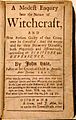
Title page of A Modest Enquiry Into the Nature of Witchcraft by John Hale (Boston, 1702)

See also
 In Spanish: Salem (Massachusetts) para niños
