
Essex County, Massachusetts facts for kids
Quick facts for kids
Essex County
|
||
|---|---|---|
   .jpg) Images, from top down, left to right: The Crane Estate in Ipswich; Heron in the Great Salt Marsh; The John Hale House in Beverly; Eaglehead in Manchester-by-the-Sea
|
||
|
||

Location within the U.S. state of Massachusetts
|
||
 Massachusetts's location within the U.S. |
||
| Country | ||
| State | ||
| Founded | 1643 | |
| Named for | Essex, England | |
| Seat | Salem and Lawrence | |
| Largest city | Lynn | |
| Area | ||
| • Total | 828 sq mi (2,140 km2) | |
| • Land | 493 sq mi (1,280 km2) | |
| • Water | 336 sq mi (870 km2) 41%% | |
| Population
(2020)
|
||
| • Total | 809,829 |
|
| • Density | 1,643/sq mi (634/km2) | |
| Time zone | UTC−5 (Eastern) | |
| • Summer (DST) | UTC−4 (EDT) | |
| Congressional districts | 3rd, 6th | |

Essex County is a county located in the northeastern part of Massachusetts, a state in the United States. In 2020, over 809,000 people lived here, making it the third-most populated county in Massachusetts. It is also one of the most populated counties in the entire country.
Essex County is part of the larger Greater Boston area. The biggest city in the county is Lynn. The county was named after Essex, a county in England.
Essex County has two traditional county seats: Salem and Lawrence. Even though the county government was dissolved in 1999, these cities still hold historical importance. The county itself is recognized as the Essex National Heritage Area by the National Park Service.
Contents
History of Essex County

Essex County was created on May 10, 1643, by the government of the Massachusetts Bay Colony. It was one of the first four "sheires" (counties) in the colony.
The county was named after Essex in England. At first, it included towns like Salem, Lynn, Ipswich, and Andover. Later, in 1680, more towns like Haverhill and Amesbury joined Essex County. Over many years, these towns were divided into the cities and towns we know today.
A famous word, gerrymandering, came from Essex County. Elbridge Gerry, who was born in Marblehead, created a strangely shaped voting district in 1812. This was done to help his political party win elections. People thought the district looked like a monster, and that's how the term "gerrymander" was born.
Geography of Essex County
Essex County is shaped a bit like a diamond. It is located in the northeastern corner of Massachusetts.
The county covers about 828 square miles. About 493 square miles are land, and 336 square miles are water. This means a large part of the county, about 41%, is covered by water.
Essex County is next to Rockingham County, New Hampshire to the north and the Atlantic Ocean to the east. To the south is Suffolk County, and to the west is Middlesex County.
Neighboring Counties
- Middlesex County (west)
- Suffolk County (south)
- Hillsborough County, New Hampshire (northwest)
- Rockingham County, New Hampshire (north)
Getting Around Essex County
Several major roads pass through Essex County, making it easy to travel. These include:
There are also two regional airports in the county: Lawrence Municipal Airport and Beverly Municipal Airport. For bigger flights, people use Logan Airport in Boston or Manchester-Boston Regional Airport in New Hampshire.
Public transportation is available too. The MBTA commuter rail has two lines, the Haverhill Line and the Newburyport Line, which connect to Boston. There are also MBTA buses and the MVRTA bus company, which serves the Merrimack Valley area of Essex County.
Special Protected Areas
Essex County has a very rich history. Because of this, the entire county has been named the Essex National Heritage Area by the National Park Service. This means the area's history and nature are protected and celebrated.
Other important protected areas include:
- Parker River National Wildlife Refuge
- Salem Maritime National Historic Site
- Saugus Iron Works National Historic Site
- Thacher Island National Wildlife Refuge
People of Essex County
| Historical population | |||
|---|---|---|---|
| Census | Pop. | %± | |
| 1790 | 57,879 | — | |
| 1800 | 61,196 | 5.7% | |
| 1810 | 71,888 | 17.5% | |
| 1820 | 74,655 | 3.8% | |
| 1830 | 82,859 | 11.0% | |
| 1840 | 94,987 | 14.6% | |
| 1850 | 131,300 | 38.2% | |
| 1860 | 165,611 | 26.1% | |
| 1870 | 200,843 | 21.3% | |
| 1880 | 244,535 | 21.8% | |
| 1890 | 299,995 | 22.7% | |
| 1900 | 357,030 | 19.0% | |
| 1910 | 436,477 | 22.3% | |
| 1920 | 482,156 | 10.5% | |
| 1930 | 498,040 | 3.3% | |
| 1940 | 496,313 | −0.3% | |
| 1950 | 522,384 | 5.3% | |
| 1960 | 568,831 | 8.9% | |
| 1970 | 637,887 | 12.1% | |
| 1980 | 633,632 | −0.7% | |
| 1990 | 670,080 | 5.8% | |
| 2000 | 723,419 | 8.0% | |
| 2010 | 743,159 | 2.7% | |
| 2020 | 809,829 | 9.0% | |
| 2023 (est.) | 810,089 | 9.0% | |
| U.S. Decennial Census 1790–1960 1900–1990 1990–2000 2010–2019 |
|||
In 2010, there were about 743,159 people living in Essex County. The population density was about 1,509 people per square mile.
Most people in the county were White (81.9%). Other groups included Black or African American (3.8%), Asian (3.1%), and American Indian (0.4%). About 16.5% of the population was of Hispanic or Latino origin.
Many people in Essex County have Irish (23.3%), Italian (17.1%), or English (12.6%) backgrounds.
The average age of people in Essex County was 40.4 years. About 32.9% of households had children under 18 living with them.
Education in Essex County
Essex County has many schools and libraries for students of all ages.
School Districts
Here are some of the school districts in Essex County:
K-12 (Kindergarten to 12th Grade):
- Amesbury Public Schools
- Andover Public Schools
- Beverly School District
- Danvers School District
- Georgetown School District
- Gloucester School District
- Hamilton-Wenham School District
- Haverhill School District
- Ipswich School District
- Lawrence School District
- Lynn Public Schools
- Lynnfield School District
- Manchester Essex Regional School District
- Marblehead Public Schools
- Methuen School District
- Newburyport School District
- North Andover School District
- Peabody Public Schools
- Pentucket Regional School District
- Rockport School District
- Salem School District
- Saugus Public Schools
- Swampscott School District
- Triton School District
Secondary (High School):
- Masconomet School District
Elementary (Primary School):
- Boxford School District
- Middleton School District
- Nahant School District
- Topsfield School District
High Schools
Public High Schools
- Amesbury High School
- Andover High School
- Beverly High School
- Danvers High School
- Georgetown High School
- Gloucester High School
- Hamilton-Wenham Regional High School
- Haverhill High School
- Ipswich High School
- Lawrence High School
- Lynn Classical High School
- Lynn English High School
- Lynnfield High School
- Manchester Essex Regional High School
- Marblehead High School
- Masconomet Regional High School
- Methuen High School
- Newburyport High School
- North Andover High School
- Peabody Veterans Memorial High School
- Pentucket Regional High School
- Rockport High School
- Salem High School
- Saugus High School
- Swampscott High School
- Triton Regional High School
Technical High Schools
These schools offer special training for jobs and careers.
- Essex Agricultural and Technical High School
- Greater Lawrence Technical School
- Lynn Vocational and Technical Institute
- North Shore Technical High School
- Whittier Regional Vocational Technical High School
Private High Schools
- Academy at Penguin Hall
- Bishop Fenwick High School
- Bradford Christian Academy
- Brooks School
- Central Catholic High School
- The Clark School (Rowley, Massachusetts)
- The Governor's Academy
- Glen Urquhart School
- Phillips Academy
- Pingree School
- Presentation of Mary Academy
- Shore Country Day School
- St. John's Preparatory School
- St. Mary's High School
- The Waring School
Colleges and Universities
After high school, students can attend these higher education institutions:
- Endicott College
- Gordon College
- Gordon-Conwell Theological Seminary
- Massachusetts School of Law
- Merrimack College
- Montserrat College of Art
- North Shore Community College
- Northern Essex Community College
- Northpoint Bible College
- Salem State University
Libraries
Essex County has many libraries that are part of larger networks:
- Merrimack Valley Library Consortium
- North of Boston Library Exchange
Economy of Essex County
Jobs and Businesses
In 2015, over 282,000 people worked in Essex County. The biggest employer in the county is Massachusetts General Hospital, which has more than 5,000 employees.
Banks
The largest banks in Essex County, based on how much money people have deposited, include:
- TD Bank, N.A.
- Salem Five Cents Bank
- Institution for Savings
- Bank of America
- Eastern Bank
Essex National Heritage Area
The Essex National Heritage Area (ENHA) was officially recognized by the U.S. Congress in 1996. This special area covers all of Essex County, about 500 square miles. It stretches from the Atlantic Coast to the Merrimack Valley.
The ENHA includes 34 cities and towns. It also has thousands of historic places that tell the story of early colonial settlements, the growth of industries like shoe-making and textiles, and the history of maritime activities like fishing and trade.
The Essex National Heritage Commission is a non-profit group that works to protect and promote the history, culture, and natural beauty of the ENHA. They help people connect with the special places in Essex County through various projects and events.
Cities and Towns of Essex County
Here are the different communities you can find in Essex County:
Cities
- Amesbury
- Beverly
- Gloucester
- Haverhill
- Lawrence (a traditional county seat)
- Lynn
- Methuen
- Newburyport
- Peabody
- Salem (a traditional county seat)
Towns
Census-Designated Places
These are areas that are recognized for census purposes but are not officially incorporated as cities or towns.
Other Villages
These are smaller communities or neighborhoods within the towns.
Images for kids
-
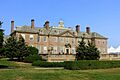
The Crane Estate in Ipswich
-
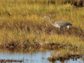
A Great Blue Heron in the Great Salt Marsh
-
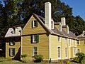
The John Hale House in Beverly
-
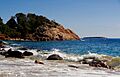
Eaglehead in Manchester-by-the-Sea
See also
 In Spanish: Condado de Essex (Massachusetts) para niños
