Saugus, Massachusetts facts for kids
Quick facts for kids
Saugus, Massachusetts
|
|||
|---|---|---|---|
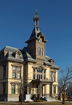
Saugus Town Hall
|
|||
|
|||
| Motto(s):
Sachems
|
|||
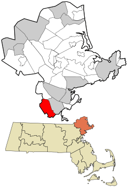
Location in Essex County and the state of Massachusetts.
|
|||
| Country | United States | ||
| State | Massachusetts | ||
| County | Essex | ||
| Settled | 1629 | ||
| Incorporated | 1815 | ||
| Government | |||
| • Type | Town Manager–Board of Selectmen/Representative town meeting | ||
| Area | |||
| • Total | 11.2 sq mi (30.6 km2) | ||
| • Land | 10.8 sq mi (28.0 km2) | ||
| • Water | 1.0 sq mi (2.6 km2) | ||
| Elevation | 21 ft (6 m) | ||
| Population
(2024)
|
|||
| • Total | 28,521 | ||
| • Density | 2,547/sq mi (932.1/km2) | ||
| Time zone | UTC-5 (Eastern) | ||
| • Summer (DST) | UTC-4 (Eastern) | ||
| ZIP code |
01906
|
||
| Area code(s) | 339 / 781 | ||
| FIPS code | 25-60015 | ||
| GNIS feature ID | 0619454 | ||
Saugus is a town in Essex County, Massachusetts, United States. It is part of the Greater Boston area. In 2020, about 28,619 people lived there. Saugus is famous for being the location of North America's first integrated iron works.
Contents
History of Saugus
Early Settlers and the Town's Name
Native Americans lived in the Saugus area for thousands of years. European settlers arrived in the 1620s. The Naumkeag, also called Pawtucket, lived near what is now Saugus. Their leader was Montowampate.
The English settlers took the name Saugus from a Pawtucket word meaning "outlet." This name referred to the Saugus River. It also described the larger region that included towns like Swampscott and Lynn. Later, in 1637, this region was renamed Lynn.
The First Iron Works in North America
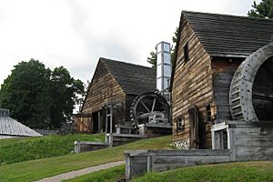
In 1646, the Saugus Iron Works started operating. It was first called Hammersmith. This was the very first integrated iron works in North America. It was also one of the most advanced in the world at that time.
The Iron Works could make over one ton of iron every day. However, it did not make enough money. It closed down around 1670.
Important Moments in Saugus History
In September 1687, Major Samuel Appleton gave a speech. He spoke from a rocky cliff near the Iron Works. He criticized the colonial governor, Sir Edmund Andros. This spot became known as Appleton's Pulpit.
Many men from Saugus fought in the American Revolutionary War. Nearly 100 men from the town joined the fight. Saugus' preacher, Parson Joseph Roby, encouraged people to support independence. He helped make sure Saugus sent many soldiers to the war.
The ice industry began in Saugus in 1804. Frederic Tudor cut ice from a pond on his family farm. He then shipped it to places like Martinique.
Growth and New Industries
In 1805, the Newburyport Turnpike was built. This road is now U.S. 1. About four miles of this road were in Saugus. At first, people thought the turnpike was a mistake. It was built over hills and swamps, and grass grew on it.
From 1840 to 1846, the road became public and tolls were stopped. When automobiles were invented, traffic on the Turnpike grew. In 1933, the road was made wider. An overpass was added to separate traffic on Route 1 and Main Street. In the 1950s, new businesses moved to Route 1. Today, these businesses bring in a lot of money for Saugus.
On February 17, 1815, Saugus officially became a town. The first town meeting was held on March 13, 1815. At that time, Saugus had 784 people. Its main business was farming.
During the Industrial Revolution, many new businesses came to Saugus. Shoes and woolen goods were made in Saugus Center. Tobacco products were made in Cliftondale and East Saugus.
Saugus' first post office opened in 1832 in East Saugus. By 1858, two more opened. Today, only the Cliftondale post office remains.
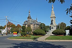
The first town hall was built in 1837. It cost $2,000. This money came from a surplus of United States revenue. In 1875, the town built its second and current town hall.
Saugus During the Civil War
During the American Civil War, 155 men from Saugus joined the Union Army. Eight others joined the Union Navy. Gustavus Fox, who was from Saugus, served as the United States Assistant Secretary of the Navy during the war. A Union Navy ship, the USS Saugus, was named after the town.
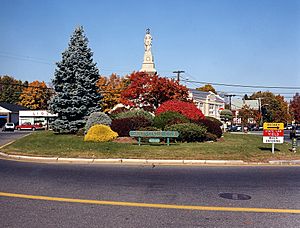
After the war, a large granite monument was given to the town. It was designed by Melzar Hunt Mosman. The monument lists the names of all the men from Saugus who fought in the Civil War. It has bronze statues of a soldier and a sailor. On top is a granite statue of a woman representing the United States. The monument was placed in Saugus Center in 1875.
Later Developments and Modern Saugus
After the Civil War, the Cliftondale area of Saugus became a big producer of tobacco. Many tobacco farms in the South had been destroyed. Waitt & Bond became a major cigar maker. A snuff factory in East Saugus was the largest in the nation.
From 1859 to 1905, Saugus had the Franklin Park harness racing track. It was also known as the Old Saugus Race Track. It closed in 1905 because people complained about the crowds it attracted.
In 1911, the racetrack became an airfield. In 1912, it was bought by the General Aviation Corporation. They named it Atwood Park. This airfield saw the first airmail delivery in New England on May 30, 1912. Famous pilots like Ruth Bancroft Law and Lincoln J. Beachey flew there. The airport closed in the 1920s.
In 1934, Breakheart Hill Forest was bought by the Metropolitan District Commission. It became a state park. The Civilian Conservation Corps built roads and trails there. In 1936, Breakheart Reservation opened to the public.
In 1947, Saugus adopted a new form of government called Plan E. Saugus was the first town in Massachusetts to do this. In 1948, James Shurtleff became the first Town Manager.
In 1948, an archaeologist named Roland W. Robbins started digging at the Saugus Iron Works site. The site had been hidden by plants. With his findings and old documents, the Iron Works was rebuilt. The Saugus Iron Works opened on September 18, 1954. It became part of the National Park Service in 1968.
Saugus is home to the oldest barber shop in the United States. George's Barber Shop in Cliftondale Square opened in 1898. It is a family business, now run by the 6th generation.
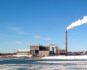
In the 1970s, the town tried to build an oil refinery and a garbage incineration plant. The refinery plans did not happen. However, the incineration plant was built. It became the first successful plant of its kind in the U.S. It is still working today.
In the 1990s and 2000s, Saugus built new public buildings. These included a public safety building, a senior center, a library, and a public works facility. The Saugus Town Hall was also renovated. In 2001, the Saugus River was dredged, a project that had been planned for a long time.
The Saugus American Little League team played in the 2003 Little League World Series. They finished in 4th place. Their comeback win against Richmond, Texas was even nominated for a sports award.
Geography and Transportation
Where is Saugus Located?
Saugus has a total area of about 30.6 square kilometers (11.2 square miles). About 28.0 square kilometers (10.8 square miles) is land. The rest, 2.6 square kilometers (1.0 square mile), is water. The town is just inland from Massachusetts Bay. The Point of Pines area of Revere separates it from the ocean.
The southern part of Saugus has Rumney Marsh. This marsh is along the Pines River, which flows into the Saugus River. The Saugus River flows through the town. There are also several ponds, like Birch Pond and Hawkes Pond. Parts of Lynn Woods Reservation, Breakheart Reservation, and Rumney Marsh Reservation are in Saugus.
Neighborhoods and Borders
Saugus has many neighborhoods. These include Saugus Center, East Saugus, North Saugus, Pleasant Hills, Lynnhurst, Oaklandvale, Hammersmith Village, Golden Hills, Blacksmith Village, Bristow, and Cliftondale. Most people live in Lynnhurst, Pleasant Hills, Cliftondale, East Saugus, and Saugus Center. Oaklandvale and North Saugus are less crowded.
Saugus is in the southern part of Essex County. It borders Lynnfield to the north, Lynn to the east, and Revere to the south. To the west, it borders Melrose and Wakefield. Saugus is about 8 miles (13 km) southwest of Salem. It is 9 miles (14 km) northeast of Boston.
Roads and Public Transport
U.S. Route 1 goes through Saugus. It is a large, six-lane highway. This part of Route 1 is a main road for people traveling from Boston to the North Shore. It has many shops and the Square One Mall.
Route 1 in Saugus was once known for its fun, unique roadside buildings. One example was the 68-foot neon cactus at the Hilltop Steak House. Some of these landmarks have been taken down or are no longer used.
Route 129 also passes through North Saugus. Route 99 ends at Route 1 in Saugus. Route 107 goes through the town as the Salem Turnpike. It crosses the Saugus River into Lynn over the Fox Hill Bridge.
The Newburyport/Rockport Line of the MBTA Commuter Rail goes through Saugus. However, there is no train station in Saugus. Several MBTA bus routes serve the town. The closest airport is Boston's Logan International Airport.
Population and People
As of 2010, Saugus had 26,628 people. There were 10,318 households. About 53% of households were married couples living together. The average household had 2.55 people.
The population was spread out by age. About 4.5% were under 5 years old. The median age was 43.9 years. This means half the people were younger than 43.9, and half were older.
The median income for a household in Saugus was $85,301. For families, it was $95,782. Only about 4.2% of the population lived below the poverty line.
Education in Saugus
Saugus is served by the Saugus Public Schools. The main school is Saugus Middle-High School.
Media and News
Saugus Community Television, or SCTV, is a local TV station. It provides local programs to the community. SCTV broadcasts on Comcast cable channels 8 (public), 9 (government), and 22 (educational).
Saugus has one newspaper, the Saugus Advocate. News about Saugus is also covered by The Daily Item of Lynn.
Since 1950, the transmitter for radio station WROL has been in Saugus. It was previously used by WHDH from 1934 to 1948.
Places to Visit in Saugus
- Appleton's Pulpit
- Belden Bly Bridge
- Boardman House
- Breakheart Reservation
- Camp Nihan
- Kowloon Restaurant
- Prankers Pond
- Rumney Marsh Reservation
- Saugus Middle-High School
- Saugus Iron Works National Historic Site
- Saugus River
- Saugus Town Hall
- Square One Mall
- George’s Barber Shop
Famous People from Saugus
Movies and TV Shows Filmed in Saugus
- American Playhouse episode "Three Sovereigns for Sarah" (1985)
- The Joneses (2009)
- Food Paradise episodes "Steak Paradise" (2008) and "Donut Paradise" (2008)
- Furry Vengeance (2010)
- Mark of the Dog Rose (2012)
- Grown Ups 2 (2013) filmed at Stackpole Field
See also
 In Spanish: Saugus (Massachusetts) para niños
 | Tommie Smith |
 | Simone Manuel |
 | Shani Davis |
 | Simone Biles |
 | Alice Coachman |


