
Amesbury, Massachusetts facts for kids
Quick facts for kids
Amesbury, Massachusetts
|
|||||
|---|---|---|---|---|---|
| City of Amesbury | |||||

Amesbury City Hall
|
|||||
|
|||||
| Nickname(s):
Carriagetown
|
|||||
| Motto(s):
"Make history here!"
|
|||||

Location in Essex County and Massachusetts
|
|||||

Amesbury, Massachusetts
Location in the United States
|
|||||
| Country | United States | ||||
| State | Massachusetts | ||||
| County | Essex | ||||
| Settled | 1642 | ||||
| Incorporated (town) | 1668 | ||||
| Incorporated (city) | 1996 | ||||
| Government | |||||
| • Type | Mayor-council city | ||||
| Area | |||||
| • Total | 13.73 sq mi (35.57 km2) | ||||
| • Land | 12.29 sq mi (31.84 km2) | ||||
| • Water | 1.44 sq mi (3.73 km2) | ||||
| Elevation | 50 ft (15 m) | ||||
| Population
(2020)
|
|||||
| • Total | 17,366 | ||||
| • Density | 1,412.79/sq mi (545.48/km2) | ||||
| Time zone | UTC−5 (Eastern) | ||||
| • Summer (DST) | UTC−4 (Eastern) | ||||
| ZIP code |
01913
|
||||
| Area code(s) | 351 / 978 | ||||
| FIPS code | 25-01260, 25-01185 | ||||
| GNIS feature ID | 0618292 | ||||


.png)
Amesbury is a city in Massachusetts, located in Essex County. It sits on the Merrimack River, close to where the river meets the ocean. Amesbury is upstream from Salisbury and across the river from Newburyport and West Newbury. In 2020, about 17,366 people lived here.
Amesbury used to be a farming and mill town. Today, many people live here. It is one of the two towns furthest north in Massachusetts, along with its neighbor, Salisbury.
Contents
Exploring Amesbury's Past
Early Settlement and Growth
The first English settler in this area was John Bayly in 1637. He crossed the Merrimack River from Newbury to build a cabin and farm the land. He later focused on fishing.
In 1638, the General Court of Massachusetts decided to create a new settlement called Merrimac. This area was once home to Native American villages. The settlers formed a local defense group, called a militia, to protect themselves. A special place where Native Americans used to gather was called Powawus, and the river there was named the Powwow River.
The settlers were mostly Puritans, who had different religious beliefs than the official Church of England. They wanted to create their own community with their own rules.
In 1639, about 60 settlers moved to the area. They planned the town's streets and burial ground. In September, the town was named Salisbury. It was much larger than the Salisbury we know today.
In 1641, the first roads were built. William Osgood built the town's first sawmill on the Powwow River in 1641. This mill used water power to cut lumber. A gristmill (for grinding grain) was added in 1642. This year, 1642, is often called the "settlement" date for Amesbury.
Becoming a Separate Town
In 1643, Massachusetts Bay Colony was divided into four shires, or large areas, for legal reasons. Salisbury was part of Norfolk Shire.
Over time, more people moved west of the Powwow River, creating a "New Town." In 1654, Salisbury was officially divided into Old Town and New Town. New Town began to manage its own affairs.
By 1658, New Town wanted to become a separate town. However, Old Town didn't agree, mainly because they would lose tax money needed to support their church. At that time, everyone had to attend the official church and pay taxes to support it.
After many requests, the General Court finally allowed New Town to become its own town in 1666. It was first called New Salisbury, but in 1667, its name was changed to Amesbury. This was because Amesbury, England, was next to Salisbury, England. Amesbury officially became a town on April 29, 1668.
Later, in 1876, the town of Merrimac was created from part of West Amesbury. In 1886, West Salisbury joined Amesbury. This brought the mill areas on both sides of the Powwow River together.
Amesbury's Industries and Changes
Amesbury started as a farming community but grew into a busy town with industries. Shipbuilding, shipping, and fishing were very important. A ferry across the Merrimack River to Newburyport was busy until bridges were built.
In the 1800s, textile mills and a nail-making factory were built near the river's falls. The Merrimac Hat Company made many hats. Starting in 1853, Amesbury became known for building carriages. This business later changed to making parts for cars. This industry ended during the Great Depression.
Amesbury also had many local newspapers over the years.
In 1997, Amesbury changed its official status from a town to a city. It adopted a mayor and city council form of government. However, voters kept the name "Town of Amesbury" for a while because they felt it was a small, charming place. In 2011, voters approved changing the official name to the "City of Amesbury."
The city has many beautiful old buildings, especially in the Federal and Victorian styles. After its downtown area was restored, many new restaurants opened.
A statue called the "Doughboy" stands at Amesbury Middle School. It honors soldiers and was made by Leonard Craske. He also created the "Fishermens' Memorial" in Gloucester. There is also a monument to Josiah Bartlett, who was born in Amesbury.
-
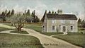
Thomas Macy House around 1905
-

Mills in 1914
-
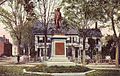
Bartlett's statue around 1910
-
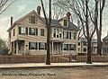
Whittier's home in 1909


Amesbury's Geography

Amesbury is located at 42°51′29″N 70°55′50″W. The city covers about 13.73 square miles (35.5 square kilometers). Most of this is land, with about 1.44 square miles (3.8 square kilometers) of water.
The Powwow River flows through Amesbury. Powwow Hill is the highest point in town, at 331 feet (101 meters) high. It was once a gathering place for Native Americans and offers views of Maine and Cape Ann.
Amesbury is on the northern banks of the Merrimack River. It shares borders with Salisbury to the east, Newburyport to the southeast, West Newbury to the southwest, Merrimac to the west, and South Hampton, New Hampshire to the north.
The Powwow River divides the town. It joins the Back River near the town center. The river flows through Lake Gardner and Tuxbury Pond. Other bodies of water include Lake Attitash and Meadowbrook Pond. Amesbury also has a town forest, Woodsom Farm, and other parks like Powwow Conservation Area.
Getting Around Amesbury

Amesbury is served by two major highways. Interstate 495 runs through town from west to east. It connects to Interstate 95 near the Salisbury town line.
Interstate 95 crosses the southeast part of Amesbury. It uses the John Greenleaf Whittier Memorial Bridge to cross the Merrimack River. This bridge is just west of the Derek S. Hines Memorial Bridge, which connects Amesbury to Deer Island. The Chain Bridge, Massachusetts's only suspension bridge, also connects Deer Island to Newburyport. The current Chain Bridge was built in 1909. It has been an important way to enter Amesbury across the Merrimack River for a long time.
The MVRTA provides bus service in Amesbury. Route 51 connects to the Haverhill train station. Route 54 connects to the Newburyport train station.
| Historical population | ||
|---|---|---|
| Year | Pop. | ±% |
| 1840 | 2,471 | — |
| 1850 | 3,143 | +27.2% |
| 1860 | 3,877 | +23.4% |
| 1870 | 5,581 | +44.0% |
| 1880 | 3,355 | −39.9% |
| 1890 | 9,798 | +192.0% |
| 1900 | 9,473 | −3.3% |
| 1910 | 9,894 | +4.4% |
| 1920 | 10,036 | +1.4% |
| 1930 | 11,899 | +18.6% |
| 1940 | 10,862 | −8.7% |
| 1950 | 10,851 | −0.1% |
| 1960 | 10,787 | −0.6% |
| 1970 | 11,388 | +5.6% |
| 1980 | 13,971 | +22.7% |
| 1990 | 14,997 | +7.3% |
| 2000 | 16,450 | +9.7% |
| 2010 | 16,283 | −1.0% |
| 2020 | 17,366 | +6.7% |
| 2022* | 17,179 | −1.1% |
| * population estimate. Source: United States Census records and Population Estimates Program data. Source: |
||
Amesbury's Population


In 2000, Amesbury had 16,450 people living in 6,380 households. About 34.5% of households had children under 18. The average household size was 2.52 people.
The population was spread out by age:
- 26.1% were under 18
- 6.1% were 18 to 24
- 33.8% were 25 to 44
- 22.0% were 45 to 64
- 12.0% were 65 or older
The average age was 37 years.
Education in Amesbury
Amesbury has several schools:
- Amesbury Public Schools
- SGT. Jordan Shay Memorial Lower Elementary School (Kindergarten to 2nd grade)
- Charles C. Cashman Elementary School (3rd to 5th grade)
- Amesbury Middle School (6th to 8th grade)
- Amesbury High School (9th to 12th grade)
- Amesbury Innovation High School (a school of choice)
- Sparhawk School (a school of choice)
In 2023, the Amesbury Elementary School closed. A new school, Shay Memorial School, was built. Now, all K-5 students are on the same property, divided between Shay Memorial and Cashman Elementary.
Amesbury High School's football team has a big rivalry with Newburyport. They play each other every Thanksgiving Day. Amesbury's mascot is the "Red Hawks."
Amesbury Public Library
The Amesbury Public Library offers many resources for learning and research. It provides access to online information from various companies. The library also has a large collection of local history and family tree information, which is open for people to use.
Fun Places to Visit
- Alliance Park: Where the USS Alliance ship was built in 1777.
- Amesbury Carriage Museum: Learn about the town's history of making carriages.
- Amesbury Friends Meeting House (1850): A historic meeting place.
- Amesbury Hat Museum: Shows hats from the old Merrimack Hat Factory.
- Amesbury Public Library: A great place to read and learn.
- Chain Bridge: A historic suspension bridge.
- Bartlett Museum, Inc. (1870): A local museum.
- Fortune Bar: A local spot.
- John Greenleaf Whittier House: The home of the famous poet.
- Lowell's Boat Shop (1793): One of the oldest boat-building shops in the country.
- Macy-Colby House (around 1654): A very old house.
- Mary Baker Eddy Historic House: The home of the founder of Christian Science.
- Old Powder House (1810): A historic building.
- Rocky Hill Meeting House (around 1785): A historic meeting house.
- Salisbury Point Railroad Historical Society: For train enthusiasts.
- Acorn Mountain Park: A park to enjoy nature.
- Maples Crossing (2021): A newer facility.
Famous People from Amesbury
- Jimmy Bannon (1871–1948), a baseball player.
- Josiah Bartlett (1729–1795), signed the Declaration of Independence and was a governor of New Hampshire.
- Nathaniel Currier (1813–1888), famous for his prints with Currier and Ives.
- Jeffrey Donovan (born 1968), an actor known for Burn Notice.
- Mary Baker Eddy (1821–1910), who started Christian Science.
- Robert Frost (1874–1963), a well-known poet.
- Susannah (North) Martin, a victim of the Salem witch trials in 1692.
- William A. Paine (1844–1929), a businessman who helped start Paine Webber.
- Harriet Prescott Spofford (1835–1921), an author.
- Paine Wingate (1739–1838), a preacher and politician.
- Al Capp, the cartoonist who created Li'l Abner, lived and is buried in Amesbury.
- John Greenleaf Whittier (1807–1892), a famous poet.
Amesbury's Global Connections
Twin towns – Sister cities
Amesbury has a special connection with:
- Esabalu, Kenya (since 1987)
See also
 In Spanish: Amesbury (Massachusetts) para niños
