
Merrimac, Massachusetts facts for kids
Quick facts for kids
Merrimac, Massachusetts
|
||
|---|---|---|

Merrimac Town Hall near Merrimac Square
|
||
|
||

Location in Essex County and the state of Massachusetts.
|
||
| Country | United States | |
| State | Massachusetts | |
| County | Essex | |
| Settled | 1638 | |
| Incorporated | 1876 | |
| Government | ||
| • Type | Open town meeting | |
| Area | ||
| • Total | 8.8 sq mi (22.9 km2) | |
| • Land | 8.5 sq mi (21.9 km2) | |
| • Water | 0.4 sq mi (1.0 km2) | |
| Elevation | 107 ft (33 m) | |
| Population
(2020)
|
||
| • Total | 6,723 | |
| • Density | 760.4/sq mi (293.6/km2) | |
| Time zone | UTC-5 (Eastern) | |
| • Summer (DST) | UTC-4 (Eastern) | |
| ZIP code |
01860
|
|
| Area code(s) | 351 / 978 | |
| FIPS code | 25-40430 | |
| GNIS feature ID | 0618301 | |

Merrimac is a small town in Essex County, Massachusetts. It is located near the border of New Hampshire. Merrimac is about 34 miles (55 km) northeast of Boston. It is also about 10 miles (16 km) west of the Atlantic Ocean.
The town was officially created on April 11, 1876. It sits on the north bank of the Merrimack River. This area is known as the Merrimack Valley. In 2020, about 6,723 people lived in Merrimac. Long ago, it was a town known for its factories. Today, it is mostly a place where people live. Merrimac is part of the larger Greater Boston area.
Contents
History of Merrimac

English settlers first came to this area in 1638. It was originally part of Salisbury. Later, it became part of Amesbury. The village of Merrimacport was an important part of this early settlement. For many years, Merrimac was a farming and fishing community. Some shipbuilding also took place.
In 1666, Amesbury separated from Salisbury. Merrimac was then called the West Parish of Amesbury. It was also known simply as West Amesbury. However, it was not yet its own official town. In 1741, the border between Massachusetts and New Hampshire was decided. This new border cut off some parts of Amesbury. The area linked to West Amesbury became the "new town" of Newton, New Hampshire.
Growth and Industry in the 1800s
In the 1800s, manufacturing grew quickly in the United States. New industrial cities like Lawrence and Lowell were built nearby. Merrimac also benefited from this growth. It became famous worldwide for making horse-drawn carriages. During this time, the main part of Merrimac, around Merrimac Square, grew separately from Merrimacport village.
In 1876, Merrimac, including Merrimacport, officially separated from Amesbury. It became its own town. People believe the town and the river are named after a Native American tribe. The word "Merrimac" means "swift water place" in their language. The town center has old brick buildings and Victorian architecture. Most of the town's people live around this area. Today, Interstate 495 separates Merrimacport from Merrimac.
Changes in the 1900s
At the start of the 1900s, many factories in New England closed. They moved to the Midwest. Merrimac and other towns in the Merrimack Valley were greatly affected. This led to a long period of economic challenges. The area has not fully recovered from these changes.
Today, Merrimac is a typical small New England town. Its population grew a lot in the 1990s and early 2000s. This happened as it became part of the larger Greater Lawrence metropolitan area.

Geography and Location
Merrimac covers about 22.9 square kilometers (8.8 square miles). About 21.9 square kilometers (8.5 square miles) is land. The remaining 1.0 square kilometer (0.4 square miles) is water. The town is located on the north bank of the Merrimack River. The river helps drain the town.
Merrimac is in the Merrimack River Valley. It is also on the coastal plain of Massachusetts. The land here has small, forested hills. Long ago, much of the land was used for pastures. The town also has several ponds, streams, and a lake called Lake Attitash.
Neighboring Towns and Roads
Merrimac is shaped roughly like a diamond. It shares borders with several towns:
- Amesbury and Lake Attitash to the northeast.
- West Newbury to the southeast.
- Haverhill to the southwest.
- Newton, New Hampshire to the north and northwest.
- South Hampton, New Hampshire to the far northeast.
- Plaistow, New Hampshire on the western corner.
Merrimac is about 14 miles (23 km) northeast of Lawrence. It is 30 miles (48 km) southeast of Manchester, New Hampshire. It is also 34 miles (55 km) north of Boston. Interstate 495 runs through Merrimac. Exit 53 provides access to the town. Massachusetts Route 110 also passes through the town, just north of I-495. There are no bridges that cross the Merrimack River directly into Merrimac. The closest bridge is the Rocks Village Bridge in Haverhill. The next bridge downstream is the Whittier Memorial Bridge in Amesbury.
Population Facts

| Historical population | ||
|---|---|---|
| Year | Pop. | ±% |
| 1880 | 2,237 | — |
| 1890 | 2,633 | +17.7% |
| 1900 | 2,131 | −19.1% |
| 1910 | 2,202 | +3.3% |
| 1920 | 2,173 | −1.3% |
| 1930 | 2,392 | +10.1% |
| 1940 | 2,320 | −3.0% |
| 1950 | 2,804 | +20.9% |
| 1960 | 3,261 | +16.3% |
| 1970 | 4,245 | +30.2% |
| 1980 | 4,451 | +4.9% |
| 1990 | 5,166 | +16.1% |
| 2000 | 6,138 | +18.8% |
| 2010 | 6,338 | +3.3% |
| 2020 | 6,723 | +6.1% |
| 2022* | 6,699 | −0.4% |
| * = population estimate. | ||
In 2020, the population of Merrimac was 6,723 people. The town has grown steadily over the years. For example, in 1880, there were 2,237 people. By 1950, the population had grown to 2,804.
In 2000, there were 6,138 people living in Merrimac. About 29% of the population was under 18 years old. About 11% of the people were 65 years or older. The average age in Merrimac was 37 years.
Education in Merrimac
Merrimac is part of the Pentucket Regional School District. The schools for Merrimac students are located in nearby West Newbury. Merrimac used to have its own high school. It closed in 1958 when Pentucket Regional High School opened.
Local Schools
Students in Merrimac attend these schools:
- Frederick N. Sweetsir School – named after a doctor who worked in Merrimac.
- Helen R. Donaghue School – named after a former principal.
- Pentucket Regional Middle School
- Pentucket Regional High School
Other School Options
For high school, students can also choose to go to vocational or agricultural schools. These schools teach special skills for jobs.
- Whittier Regional Vocational Technical High School
- Essex Agricultural and Technical High School
Notable People from Merrimac
Many interesting people have come from Merrimac.
- Dennis Berran – a baseball player for the Chicago White Sox.
- Pat Freiermuth – a football player for the NFL's Pittsburgh Steelers. He was drafted in 2021.
- Richard P. Gabriel – a computer scientist known for his work with the Lisp programming language.
- Ephraim Morse – an early settler of San Diego, California. He helped start and develop Balboa Park.
- Henry Boynton Smith – a famous Presbyterian theologian.
- Kevin J. Sullivan – a Massachusetts politician and former mayor of Lawrence.
- George W. Weymouth – a Massachusetts politician and former U.S. Representative.
- John Greenleaf Whittier – a well-known poet and activist.
Places to Visit
Merrimac has several interesting places to explore:
- Lake Attitash (and Indian Head Park) – a beautiful lake area.
- The Merrimac Public Library – a great place to find books and learn. It is part of the Merrimack Valley Library Consortium.
- Merrimac Square – the historic center of town.
- Merrimac Town Forest – a natural area for outdoor activities.
- Merrimac Training Field – a historic training ground.
- Merrimacport – a historic village within Merrimac.
Annual Events
Merrimac hosts some fun events each year:
- The Merrimac Santa Parade – a festive parade during the holidays.
- Merrimac Old Home Days – a community celebration.
Images for kids
-
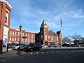
Town Hall on the Square
-
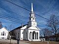
Pilgrim Congregational Church
-
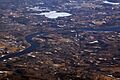
Aerial view of Merrimac and neighboring West Newbury


See also
 In Spanish: Merrimac (Massachusetts) para niños
