
Salisbury, Massachusetts facts for kids
Quick facts for kids
Salisbury, Massachusetts
|
|||
|---|---|---|---|

Salisbury Beach in 1906
|
|||
|
|||

Location in Essex County and Massachusetts
|
|||
| Country | United States | ||
| State | Massachusetts | ||
| County | Essex | ||
| Settled | 1638 | ||
| Incorporated | 1639 | ||
| Government | |||
| • Type | Open town meeting | ||
| Area | |||
| • Total | 17.9 sq mi (46.2 km2) | ||
| • Land | 15.4 sq mi (40.0 km2) | ||
| • Water | 2.4 sq mi (6.2 km2) | ||
| Elevation | 25 ft (8 m) | ||
| Population
(2020)
|
|||
| • Total | 9,236 | ||
| • Density | 516.0/sq mi (199.91/km2) | ||
| Time zone | UTC−5 (Eastern) | ||
| • Summer (DST) | UTC−4 (Eastern) | ||
| ZIP Code |
01952
|
||
| Area code(s) | 351/978 | ||
| FIPS code | 25-59245 | ||
| GNIS feature ID | 0618310 | ||


Salisbury is a cool coastal town in Essex County, Massachusetts. It's a popular spot for summer vacations, right on the Atlantic Ocean near the New Hampshire border. You can find the new Salisbury Beach Boardwalk here, with shops, restaurants, arcades, and great ocean views. In 2020, about 9,236 people lived in Salisbury.
Contents
History of Salisbury
Early Days: Before European Settlers
For thousands of years, people lived in the area now called Salisbury. At a place called Morrill Point, scientists found human remains that are 7,000 years old. Some clues even suggest people lived there as far back as 8,500 years ago!
When Europeans first arrived, the Pentucket Tribe lived north of the Merrimack River. They were part of the Pennacook group and would stay near the coast during certain seasons to fish. Unlike other towns that worked with the native people, Salisbury was settled by English colonists. They built a strong, protected town with a garrison house and a militia to defend against attacks.
Colonial Times: English Settlement
The English settled Salisbury in 1638 and first called it Colchester. In 1640, it officially became Salisbury, named after a town in England. This was the hometown of Christopher Batt, who helped train the colonists' militia.
The first settlement was shaped like a half-circle. This design helped people quickly reach the garrison house if there was danger. These old roads still exist today, forming a triangle with Elm Street, School Street, and Bridge Road. Besides native peoples, early settlers also worried about wolves, which were common and would attack their farm animals.
Original residents, like Richard Currier, received a small house lot in the town center. They also got a larger piece of land outside the center for farming. Families also owned "sweepage lots" near the beach, where they gathered hay from the salt marsh. Back then, most of the area was thick virgin forest that had to be cleared for homes and farms.
Richard Currier was a millwright and one of Salisbury's first settlers. He received land in 1640, 1641, and 1642. In 1654, some families moved west of the Powwow River. This new area later became the town of Amesbury in 1668. Richard Currier was one of the leaders who signed the agreement for this new settlement.
Salisbury as a Resort Town
In 1866, Beach Road was built, making it easy to reach Salisbury's beautiful five miles (8 km) of beach. The town quickly became a popular summer resort! It was filled with hotels, restaurants, shops, cottages, arcades, and amusement parks.
A famous carousel called The Flying Horses, carved by Charles I. D. Looff, arrived in 1914. John Miller built The Sky Rocket, Salisbury Beach's first roller coaster. A Dodgem ride was also popular from 1920 to 1980. Many famous entertainers performed here, including Glenn Miller, Ella Fitzgerald, Louis Armstrong, Frank Sinatra, and Liberace.
The resort was very lively until the 1960s, but then it slowly changed. The last roller coaster, WildCat, was taken down in 1976. Pirate's Fun Park, the last small amusement park, closed in 2004. Today, condominiums stand where it once was.
The coastline of Salisbury is facing challenges from erosion. In March 2024, some residents built artificial sand dunes to protect their homes. However, a big storm washed them away in just three days.
-
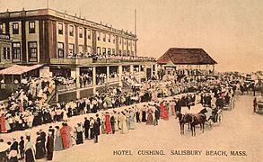
Hotel Cushing c. 1905
-
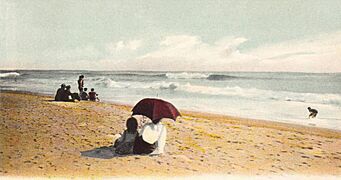
The surf in 1906
-
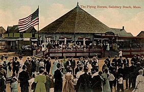
The Flying Horses c. 1914
-
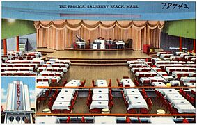
The Frolics, Salisbury Beach, Mass.
-
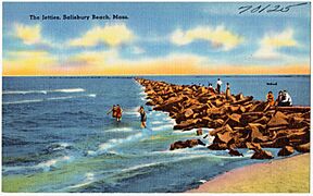
The jetties, Salisbury Beach


.jpg)
.jpg)
Geography of Salisbury
Salisbury is the northernmost town in Massachusetts. It covers about 17.9 square miles (46.2 km2). Most of this area is land (15.4 square miles or 40.0 km2), and about 2.4 square miles (6.2 km2) is water.
The town is located along the northern side of the Merrimack River where it meets the ocean. To the east is the Atlantic Ocean. To the south, across the Merrimack River, is Newburyport. To the west is Amesbury, and to the north is Seabrook, New Hampshire.
Salisbury is home to Salisbury Beach State Reservation, a large park that includes the entire coastline. There are also wildlife areas like Ram Island and Carr Island in the Merrimack River. A lot of the town is covered by marshes, especially in the eastern parts. Several small rivers and creeks also flow through the town. Salisbury has three main areas: Salisbury Beach, Salisbury Plains, and Browns Point.
Education in Salisbury
Salisbury has one public school for younger students, called Salisbury Elementary School. After elementary school, students go to Triton Regional Middle School. For high school, students attend Triton Regional High School. Students from Newbury and Rowley also go to Triton Regional High School.
Getting Around Salisbury
Salisbury is located along the northern end of U.S. Route 1 in Massachusetts. This road crosses into town over the Newburyport Turnpike Bridge. Interstate 95 in Massachusetts and Interstate 495 also end near Salisbury. These highways make it easy to get to the beaches and other nearby towns.
The Merrimack Valley Regional Transit Authority provides bus service in Salisbury. This helps connect the town to other communities nearby. The closest train station is in Newburyport.
Population of Salisbury
| Historical population | ||
|---|---|---|
| Year | Pop. | ±% |
| 1790 | 1,780 | — |
| 1800 | 1,855 | +4.2% |
| 1810 | 2,047 | +10.4% |
| 1820 | 2,006 | −2.0% |
| 1830 | 2,519 | +25.6% |
| 1840 | 2,739 | +8.7% |
| 1850 | 3,100 | +13.2% |
| 1860 | 3,310 | +6.8% |
| 1870 | 3,776 | +14.1% |
| 1880 | 4,079 | +8.0% |
| 1890 | 1,316 | −67.7% |
| 1900 | 1,558 | +18.4% |
| 1910 | 1,658 | +6.4% |
| 1920 | 1,701 | +2.6% |
| 1930 | 2,194 | +29.0% |
| 1940 | 2,376 | +8.3% |
| 1950 | 2,695 | +13.4% |
| 1960 | 3,154 | +17.0% |
| 1970 | 4,179 | +32.5% |
| 1980 | 5,973 | +42.9% |
| 1990 | 6,882 | +15.2% |
| 2000 | 7,827 | +13.7% |
| 2010 | 8,283 | +5.8% |
| 2020 | 9,236 | +11.5% |
| 2022* | 9,189 | −0.5% |
| * = population estimate. Source: United States Census records and Population Estimates Program data. |
||
In 2000, there were 7,827 people living in Salisbury. About 29.5% of households had children under 18. The average household had about 2.53 people.
The median age in Salisbury in 2000 was 39 years old. About 23.6% of the population was under 18. The median income for a household was $49,310.
Fun Places to Visit in Salisbury
- Salisbury Beach Boardwalk
- Allen Rock
- Ann's Diner
- Badgers Rock
- Blue Ocean Music Hall
- Joe's Playland
- Rings Island
- Salisbury Beach State Reservation
- Hideaway Pub
- East Salisbury one room School House of 1882
Notable People from Salisbury
- John Clough, one of the town's founders, came from England in 1635.
- Bob Corkum (born 1967), a professional ice hockey player.
- Caleb Cushing (1800–1879), a well-known congressman.
- Hannah Webster Foster (1758/59–1840), a novelist.
- Horatio Balch Hackett (1808–1875), a scholar who studied the Bible.
- Susannah Martin (1621–1692), a woman accused during the witch trials.
- Amos Morrill (1809–1884), a judge.
- James Pike (1818–1895), another congressman.
- Redford Webster (1761–1833), an apothecary, politician, and historian.
- John Wheelwright (c. 1592–1679), a clergyman.
Images for kids
-
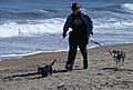
On a windy September beach
-
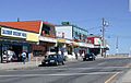
View of the center looking towards beach
-
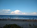
Salisbury Beach, just south of the center, in August 2020


See also
 In Spanish: Salisbury (Massachusetts) para niños
