Plaistow, New Hampshire facts for kids
Quick facts for kids
Plaistow, New Hampshire
|
||
|---|---|---|

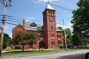
Plaistow Town Hall
|
||
|
||

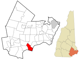
Location in Rockingham County and the state of New Hampshire.
|
||
| Country | United States | |
| State | New Hampshire | |
| County | Rockingham | |
| Incorporated | 1749 | |
| Villages |
|
|
| Area | ||
| • Total | 10.60 sq mi (27.45 km2) | |
| • Land | 10.59 sq mi (27.43 km2) | |
| • Water | 0.008 sq mi (0.02 km2) 0.06% | |
| Elevation | 102 ft (31 m) | |
| Population
(2020)
|
||
| • Total | 7,830 | |
| • Density | 739/sq mi (285.4/km2) | |
| Time zone | UTC-5 (Eastern) | |
| • Summer (DST) | UTC-4 (Eastern) | |
| ZIP code |
03865
|
|
| Area code(s) | 603 | |
| FIPS code | 33-62500 | |
| GNIS feature ID | 0873701 | |
Plaistow is a town in Rockingham County, New Hampshire, United States. In 2020, about 7,830 people lived there. It's a cool place with a lot of history and fun traditions.
Contents
History of Plaistow
Plaistow became an official town in 1749. This happened after a long argument was settled in 1739. The argument was about the border between the Province of Massachusetts Bay and the Province of New Hampshire.
Plaistow is special because it's the only town outside the United Kingdom with this name. In 1776, the western part of Plaistow became its own town, called Atkinson.
The town hall you see today was built in 1895. Every year, Plaistow celebrates "Old Home Day." This celebration includes a parade, fireworks, and a carnival. It's a big party to celebrate the town's birthday!
Plaistow's Geography
Plaistow covers about 27.45 square kilometers (about 10.6 square miles). Only a tiny bit of this area is water. The highest point in Plaistow is a hill that is about 384 feet (117 meters) above sea level. This hill is located near the northern part of town.
The Little River flows through Plaistow. This river flows south and eventually joins the Merrimack River in Massachusetts.
Neighboring Towns
Plaistow shares its borders with several other towns:
- Kingston (to the north)
- Newton (to the northeast)
- Merrimac, Massachusetts (to the east at one spot)
- Haverhill, Massachusetts (to the south)
- Atkinson (to the west)
- Hampstead (to the northwest)
People of Plaistow
| Historical population | |||
|---|---|---|---|
| Census | Pop. | %± | |
| 1790 | 521 | — | |
| 1800 | 459 | −11.9% | |
| 1810 | 424 | −7.6% | |
| 1820 | 492 | 16.0% | |
| 1830 | 591 | 20.1% | |
| 1840 | 626 | 5.9% | |
| 1850 | 748 | 19.5% | |
| 1860 | 861 | 15.1% | |
| 1870 | 879 | 2.1% | |
| 1880 | 1,062 | 20.8% | |
| 1890 | 1,085 | 2.2% | |
| 1900 | 1,027 | −5.3% | |
| 1910 | 1,173 | 14.2% | |
| 1920 | 1,368 | 16.6% | |
| 1930 | 1,366 | −0.1% | |
| 1940 | 1,414 | 3.5% | |
| 1950 | 2,082 | 47.2% | |
| 1960 | 2,915 | 40.0% | |
| 1970 | 4,712 | 61.6% | |
| 1980 | 5,609 | 19.0% | |
| 1990 | 7,316 | 30.4% | |
| 2000 | 7,747 | 5.9% | |
| 2010 | 7,609 | −1.8% | |
| 2020 | 7,830 | 2.9% | |
| U.S. Decennial Census | |||
In 2020, the population of Plaistow was 7,830 people. The town has grown quite a bit over the years. For example, in 1790, only 521 people lived here!
Education in Plaistow
Plaistow has several schools that serve its students and those from nearby towns.
- Timberlane Regional High School is for students in grades 9-12.
- Timberlane Regional Middle School is for students in grades 6-8.
- These schools also serve students from Atkinson, Danville, and Sandown.
- Pollard Elementary School is just for Plaistow children, from kindergarten to grade 5.
Timberlane Regional High School is known for its successful music, theater, wrestling, and softball programs. Students can also take special career-focused classes. These classes are offered at Salem High School and Pinkerton Academy. Students in this program can even earn an associate's degree when they graduate high school!
Economy and Transportation
Plaistow's economy is mostly found along New Hampshire Route 125 (also called Plaistow Road). This road runs north and south. It connects Plaistow to Haverhill, Massachusetts, in the south and to towns like Kingston in the north. You'll find many local shops and big chain stores along Route 125. This road can get very busy with traffic, especially during rush hour and on weekends.
Other important roads include:
- Route 121A (Main Street) runs through the center of Plaistow.
- New Hampshire Route 108 runs along the eastern edge of town.
- NH 121 briefly crosses the southwestern part of town.
The Pan Am Railways train line also runs through Plaistow. This line is used by Amtrak passenger trains and freight trains. If you want to catch an Amtrak train, stations are nearby in Haverhill and Exeter. There's also a bus service, MVRTA bus 13, that connects Haverhill to Wal-Mart on Route 125.
Notable People
- Daniel Peaslee (1773–1827), a politician and judge from Vermont.
- Thomas Toth, a Canadian runner.
See also
 In Spanish: Plaistow (Nuevo Hampshire) para niños
 | James B. Knighten |
 | Azellia White |
 | Willa Brown |


