Atkinson, New Hampshire facts for kids
Quick facts for kids
Atkinson, New Hampshire
|
|
|---|---|

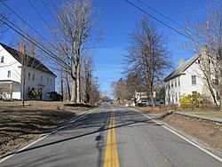
Main Street
|
|

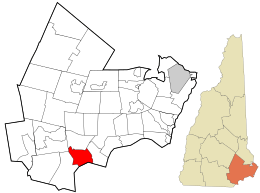
Location in Rockingham County and the state of New Hampshire.
|
|
| Country | United States |
| State | New Hampshire |
| County | Rockingham |
| Incorporated | 1767 |
| Government | |
| • Type | SB2 |
| Area | |
| • Total | 11.4 sq mi (29.4 km2) |
| • Land | 11.2 sq mi (28.9 km2) |
| • Water | 0.2 sq mi (0.5 km2) 1.61% |
| Elevation | 302 ft (92 m) |
| Population
(2020)
|
|
| • Total | 7,087 |
| • Density | 635/sq mi (245.3/km2) |
| Time zone | UTC-5 (Eastern) |
| • Summer (DST) | UTC-4 (Eastern) |
| ZIP code |
03811
|
| Area code(s) | 603 |
| FIPS code | 33-02340 |
| GNIS feature ID | 0873535 |
Atkinson is a town located in Rockingham County, New Hampshire, United States. It's a lovely place with a rich history. In 2020, about 7,087 people lived there.
Contents
History of Atkinson
Atkinson has a long and interesting history, going back to the time of the American Revolution. The town officially became a town on September 3, 1767. It was named after Colonel Theodore Atkinson, who owned a lot of land in the area.
Atkinson Academy's Story
Atkinson Academy is a very old school, known as the second-oldest school in the country that taught both boys and girls. It started in 1787 as a school just for boys. Important people like Reverend Stephen Peabody, General Nathaniel Peabody, and Doctor William Cogswell helped create it.
Just four years later, in 1791, the school started letting girls attend too! The original school building sadly burned down in 1802. But a new one was built in 1803 for about $2,500. This building is still part of the academy today, even though it has been made bigger over the years.
Kimball House Museum
The Kimball House Museum is another important historical building in Atkinson. It was built in 1772 by Reverend Stephen Peabody. Later, in 1907, a summer visitor named Rev. Joseph A. Kimball bought the building. He wanted to turn it into a library for the town, which was a wonderful gift to the community.
You can learn even more about Atkinson's past in the book Atkinson Then and Now. This book is available at the Atkinson Public Library on Academy Avenue. In 2017, Atkinson celebrated its 250th birthday with a big party during Labor Day weekend!
Geography of Atkinson
Atkinson is located in the southeastern part of New Hampshire. It's in the southwestern area of Rockingham County. To the south, it shares a border with the city of Haverhill, Massachusetts.
Land and Water
The town covers a total area of about 29.4 square kilometers (11.4 square miles). Most of this area, about 28.9 square kilometers (11.2 square miles), is land. The rest, about 0.5 square kilometers (0.2 square miles), is water. Water makes up about 1.61% of the town's total area.
The highest point in Atkinson is a place called Hog Hill. It's located north of the town center and stands about 302 feet (92 meters) above sea level. Water flows from Atkinson into two rivers: the Spicket River to the west and the Little River to the east. Both of these rivers flow south and eventually join the larger Merrimack River.
Stage Coach Byway
In 2011, a part of Main Street in Atkinson was given a special name: the "Stage Coach Byway." This section is about 3.74 miles long and is recognized for its scenic and cultural importance by the New Hampshire Scenic and Cultural Byways program.
Neighboring Towns
Atkinson is surrounded by several other towns:
- Hampstead (to the north)
- Plaistow (to the east)
- Haverhill, Massachusetts (to the south)
- Salem (to the west)
- Derry (to the northwest)
Population Changes
| Historical population | |||
|---|---|---|---|
| Census | Pop. | %± | |
| 1790 | 479 | — | |
| 1800 | 474 | −1.0% | |
| 1810 | 556 | 17.3% | |
| 1820 | 563 | 1.3% | |
| 1830 | 555 | −1.4% | |
| 1840 | 567 | 2.2% | |
| 1850 | 600 | 5.8% | |
| 1860 | 546 | −9.0% | |
| 1870 | 488 | −10.6% | |
| 1880 | 502 | 2.9% | |
| 1890 | 483 | −3.8% | |
| 1900 | 442 | −8.5% | |
| 1910 | 440 | −0.5% | |
| 1920 | 413 | −6.1% | |
| 1930 | 407 | −1.5% | |
| 1940 | 434 | 6.6% | |
| 1950 | 492 | 13.4% | |
| 1960 | 1,017 | 106.7% | |
| 1970 | 2,291 | 125.3% | |
| 1980 | 4,397 | 91.9% | |
| 1990 | 5,188 | 18.0% | |
| 2000 | 6,178 | 19.1% | |
| 2010 | 6,751 | 9.3% | |
| 2020 | 7,087 | 5.0% | |
| U.S. Decennial Census | |||
The population of Atkinson has changed a lot over the years. In 1790, there were 479 people living here. By 2020, the population had grown to 7,087. This shows how the town has developed and grown over more than two centuries.
Getting Around Atkinson
Two main New Hampshire state routes pass through Atkinson, making it easy to travel to and from the town.
- NH 111 goes through the very northern part of Atkinson. It passes near Island Pond. This route connects Atkinson to Windham in the southwest and Hampstead to the east.
- NH 121 is Atkinson's Main Street. It crosses the center of town from north to southeast. This route links Hampstead in the north to Plaistow in the south. It then ends in the northern part of Haverhill, Massachusetts.
Nearby Travel Hubs
If you need to fly, the closest airport is Manchester–Boston Regional Airport. This airport is located near the towns of Londonderry and Manchester. For train travel, the nearest service is the Haverhill Line of the MBTA Commuter Rail. You can catch this train at Haverhill station in Massachusetts. This station also serves as the Amtrak stop for the area.
Education in Atkinson
Students in Atkinson attend schools that are part of the Timberlane Regional School District. This school district serves several communities, including Atkinson, Danville, Plaistow, and Sandown.
The district has five elementary schools, one middle school, and one high school. Students from Atkinson typically go to Atkinson Academy, which is known for being one of the oldest co-educational schools still operating in the United States. After elementary school, students attend Timberlane Regional Middle School and then Timberlane Regional High School.
Notable People from Atkinson
Some interesting people have connections to Atkinson:
- Brad Delp (1951–2007) was the lead singer for the famous rock bands Boston and RTZ.
- John Noyes (1764–1841) was a politician who represented Vermont in the United States House of Representatives.
- Elizabeth Barrows Ussher (1873–1915) was a Christian missionary. She was also a witness to the terrible events of the Armenian Genocide.
See also
 In Spanish: Atkinson (Nuevo Hampshire) para niños
 | Laphonza Butler |
 | Daisy Bates |
 | Elizabeth Piper Ensley |

