
Derry, New Hampshire facts for kids
Quick facts for kids
Derry, New Hampshire
|
||
|---|---|---|

The Adams Memorial Building, home of the Derry Opera House
|
||
|
||
| Nickname(s):
"Spacetown"
|
||

Location in Rockingham County, New Hampshire
|
||
| Country | United States | |
| State | New Hampshire | |
| County | Rockingham | |
| Incorporated | 1827 | |
| Villages | ||
| Area | ||
| • Total | 36.3 sq mi (94.0 km2) | |
| • Land | 35.5 sq mi (91.9 km2) | |
| • Water | 0.8 sq mi (2.1 km2) 2.26% | |
| Elevation | 282 ft (86 m) | |
| Population
(2020)
|
||
| • Total | 34,317 | |
| • Density | 967/sq mi (373.5/km2) | |
| Time zone | UTC-5 (Eastern) | |
| • Summer (DST) | UTC-4 (Eastern) | |
| ZIP code |
03038
|
|
| Area code(s) | 603 | |
| FIPS code | 33-17940 | |
| GNIS feature ID | 0873578 | |

Derry is a town in Rockingham County, New Hampshire, United States. In 2020, about 34,317 people lived there. Even though it's called a town, Derry is the biggest community in Rockingham County. It's also the 4th largest in the whole state of New Hampshire.
Derry's nickname is "Spacetown." This is because Alan Shepard, the first American astronaut in space, was born here. Famous poet Robert Frost and his family also lived in Derry for a while. The town includes a central area called the Derry census-designated place (CDP) and the village of East Derry.
Contents
History of Derry
The area was first settled in 1719 by Scots-Irish families. It was part of a larger town called Londonderry. Derry became its own town in 1827. Like Londonderry, it was named after the city of Derry in Ireland. The Irish word Doire means "oak grove."
An interesting fact is that the first potato planted in the United States was in Derry. This happened in the town's common field in 1719. Derry is also home to two of America's oldest private schools. Pinkerton Academy, founded in 1814, is still open today.
Derry used to be a big center for making linen and leather. But in the 1900s, these industries moved to other places. Around World War II, Derry was mostly a quiet farming community.
From 1900 to 1911, the famous poet Robert Frost lived on a farm in Derry. His grandfather bought the farm for him. Today, the Robert Frost Farm is a special historic place. You can visit it for tours, poetry readings, and other events.
After World War II, Derry grew a lot. Many people moved here because it's close to Boston and Manchester. Also, the highway Interstate 93 was built through the town. This caused a huge increase in population. However, since the year 2000, the population has stayed about the same.
A railroad line used to run through Derry. Now, most of this old line is a rail trail for walking and biking. There are plans to possibly reopen the line for trains in the future.
Old Postcards of Derry
-
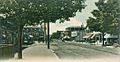
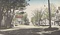
Broadway c. 1905
-
Birch Street c. 1905
-
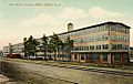
HEH Shoe Factory in 1909
-
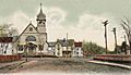
Hildreth Hall in 1914
-
Thornton Square c. 1915


Geography of Derry
Derry is located in southern New Hampshire. It is about 12 miles (19 km) southeast of Manchester. Manchester is the largest city in the state. Derry is also about 16 miles (26 km) northwest of Lawrence, Massachusetts.
Major roads like Interstate 93 and New Hampshire Routes 28, 28 Bypass, and 102 cross through the town. The town covers a total area of about 36.3 square miles (94.0 km2). Most of this area is land, with a small part being water.
Beaver Brook flows through Derry. It eventually joins the Merrimack River. Island Pond is on the edge of town. The highest point in Derry is Warner Hill, which is 605 feet (184 meters) above sea level. On a clear day, you can even see the Boston skyline from the top!
Derry's downtown area is in the western part of town. It's where Routes 102 and 28 meet. The village of East Derry is about 2 miles (3.2 km) to the east. Both these areas are part of the Derry census-designated place.
Neighboring Towns
Derry shares borders with several other towns:
- Chester (north)
- Sandown (northeast)
- Hampstead (east)
- Atkinson (southeast)
- Salem (southeast)
- Windham (south)
- Londonderry (west)
- Auburn (northwest)
Derry's Climate
Derry has four distinct seasons. Winters are long, cold, and snowy. Summers are very warm and a bit humid. Spring and fall are shorter seasons with cool, crisp weather. Rain and snow fall throughout the year.
People of Derry (Demographics)
| Historical population | |||
|---|---|---|---|
| Census | Pop. | %± | |
| 1830 | 2,178 | — | |
| 1840 | 2,034 | −6.6% | |
| 1850 | 1,850 | −9.0% | |
| 1860 | 1,995 | 7.8% | |
| 1870 | 1,809 | −9.3% | |
| 1880 | 2,140 | 18.3% | |
| 1890 | 2,604 | 21.7% | |
| 1900 | 3,583 | 37.6% | |
| 1910 | 5,123 | 43.0% | |
| 1920 | 5,382 | 5.1% | |
| 1930 | 5,131 | −4.7% | |
| 1940 | 5,400 | 5.2% | |
| 1950 | 5,826 | 7.9% | |
| 1960 | 6,987 | 19.9% | |
| 1970 | 11,712 | 67.6% | |
| 1980 | 18,875 | 61.2% | |
| 1990 | 29,603 | 56.8% | |
| 2000 | 34,021 | 14.9% | |
| 2010 | 33,109 | −2.7% | |
| 2020 | 34,317 | 3.6% | |
| U.S. Decennial Census | |||
In 2020, Derry had 34,317 residents. Most people (88.1%) identified as White. About 2.3% were African American, and 2.3% were Asian. Around 4.6% of the population identified as Hispanic or Latino.
In 2010, there were 12,537 households in Derry. About 35% of these households had children under 18 living there. The average household had 2.62 people. The average family had 3.10 people.
The median age in Derry was 38.2 years old. About 24.7% of the population was under 18. About 8.7% were 65 years or older.
In 2000, the median income for a household in Derry was about $54,634. This means half of the households earned more than this, and half earned less.
Economy and Jobs
Derry has many different types of jobs. Here are some of the biggest employers in town:
| # | Employer | # of employees |
|---|---|---|
| 1 | Derry Cooperative School District | 620 |
| 2 | HCA Health Services of New Hampshire (Parkland Medical Center) | 532 |
| 3 | Pinkerton Academy | 462 |
| 4 | Town of Derry | 364 |
| 5 | Walmart | 265 |
| 6 | Hannaford | 142 |
| 7 | Shaw's | 105 |
| 8 | Fireye | 100 |
| 9 | Benson's Hardware | 50 |
| 10 | Total Air Supply | 40 |
Getting Around Derry (Transportation)
Several major roads pass through Derry. These include five New Hampshire state highways and one Interstate Highway.
- NH 28 runs north and south through Derry.
- NH 28 Bypass is a route that helps drivers get around the main part of town.
- NH 102 goes from west to east through Derry. It crosses the center of town at a traffic circle.
- NH 111 crosses a very small part of the southeastern corner of town.
- NH 121 crosses a tiny section in the northeastern corner.
- Interstate 93 goes through the southwestern part of Derry. There are no exits directly in Derry, but an exit in nearby Londonderry is very close.
The closest airport for flying is Manchester–Boston Regional Airport. Derry does not have passenger train service right now. However, the old train station in town is now a hub for businesses. You can find train services in nearby cities like Haverhill, Massachusetts.
Schools in Derry (Education)

Derry has several schools for students of all ages.
Public Schools
The Derry Cooperative School District manages the public schools.
- Elementary Schools:
- Ernest P. Barka Elementary School
- East Derry Memorial Elementary School
- Grinnell Elementary School
- South Range Elementary School
- Middle Schools:
- Gilbert H. Hood Middle School
- West Running Brook Middle School
Pinkerton Academy is a large high school that serves Derry. It also serves students from Chester, Hampstead, Auburn, Hooksett, and Candia.
Private Schools
- Nutfield Cooperative School (for pre-school and kindergarten)
- Saint Thomas Aquinas School (for pre-kindergarten through 8th grade)
- Derry Montessori School (for ages 3 through 3rd grade)
- Next Charter School (for grades 9 through 12)
Media in Derry
Derry has its own local media.
- The Derry News is a weekly newspaper.
- WWJE-DT is a local television station.
- Derry Community Television, also called DerryCAM, is a public TV channel. It shows local programs on cable TV.
Famous People from Derry

Many notable people have connections to Derry:
- Samantha Brown (born 1970), a TV host who used to be on the Travel Channel.
- Caleb Chapman (born 1973), a musician.
- Tricia Dunn-Luoma (born 1974), an Olympic gold medalist in hockey.
- Robert Frost (1874–1963), a famous poet who won the Pulitzer Prize four times.
- Brendan James (born 1979), a singer-songwriter and pianist.
- Priscilla Lane (1915–1995), an actress.
- Alan Shepard (1923–1998), the first American in space and one of 12 people to walk on the Moon.
- John Stark (1728–1822), a major general in the Revolutionary War.
- Matthew Thornton (1714–1803), one of the Founding Fathers who signed the United States Declaration of Independence.
- Matt Taven (born 1985), a professional wrestler.
- Paul Thompson (born 1988), a hockey player.
Places to Visit in Derry
Derry has several interesting places to visit:
- Adams Memorial Building
- Derry Historical Society and Museum
- Robert Frost Farm, a National Historic Landmark
- Taylor Mill State Historic Site
- Rockingham Recreational Trail, a path for walking and biking on an old railroad line.
Sister City
Derry has a sister city:
 Cherepovets, Vologda Oblast, Russia
Images for kids
-
Broadway c. 1905
-
Birch Street c. 1905
-
HEH Shoe Factory in 1909
-
Hildreth Hall in 1914
-
Thornton Square c. 1915
See also
 In Spanish: Derry (Nuevo Hampshire) para niños
