Windham, New Hampshire facts for kids
Quick facts for kids
Windham, New Hampshire
|
||
|---|---|---|
|
Town
|
||
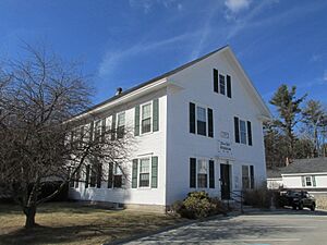
Town hall
|
||
|
||
| Motto(s):
Old Values, New Horizons
|
||
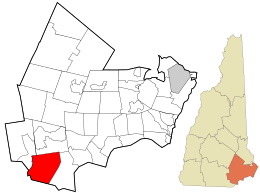
Location in Rockingham County and the state of New Hampshire
|
||
| Country | United States | |
| State | New Hampshire | |
| County | Rockingham | |
| Incorporated | 1742 | |
| Villages |
|
|
| Area | ||
| • Total | 27.78 sq mi (71.95 km2) | |
| • Land | 26.75 sq mi (69.27 km2) | |
| • Water | 1.03 sq mi (2.68 km2) 3.73% | |
| Elevation | 194 ft (59 m) | |
| Population
(2020)
|
||
| • Total | 15,817 | |
| • Density | 592/sq mi (228.4/km2) | |
| Time zone | UTC-5 (Eastern) | |
| • Summer (DST) | UTC-4 (Eastern) | |
| ZIP code |
03087
|
|
| Area code(s) | 603 | |
| FIPS code | 33-85780 | |
| GNIS feature ID | 0873758 | |
Windham is a town in Rockingham County, New Hampshire, United States. It's a suburban area, meaning it's close to a city but has a more spread-out, residential feel. In 2020, about 15,817 people lived here. This was an increase from 13,592 people in 2010, showing that Windham is a growing community.
Contents
History of Windham
The land where Windham now stands was first home to the Pawtucket Native Americans. Later, in 1719, immigrants from Scotland and Ireland began to settle here. This whole area was called "Nutfield" and included nearby towns like Derry and Londonderry.
In 1721, some of these early settlers asked to form their own separate community. Governor Benning Wentworth agreed in 1742. One idea is that the town was named after Windham, Ireland, to remember where the settlers came from. Another idea is that it was named after Sir Charles Wyndham, 2nd Earl of Egremont. He was a member of the British Parliament and a friend of Governor Wentworth. Windham was originally a part of Londonderry. It was the second town Governor Wentworth officially recognized after the border between New Hampshire and Massachusetts was set. The first count of people in Windham happened in 1790, and it showed 663 residents.
Famous Landmarks in Windham
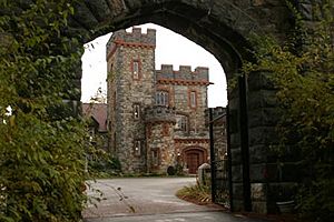
Windham has several important historical places. These include the Searles School and Chapel, Searles Castle, the town center, and the Armstrong Memorial Building. Searles Castle is one of the most well-known landmarks.
Edward Francis Searles, who was an interior decorator and collector of old items, built the castle. The architect, Henry Vaughn, designed the castle to look like the Stanton Harcourt Manor in England. It was finished in 1915 and cost a lot of money to build. The castle has more than 20 rooms and can be rented for events. In 1909, Mr. Searles also put up a special plaque to honor Governor Dinsmoor near where he was born. This plaque is now a historic landmark.
Recent Events in Windham
In 2021, Windham gained attention because of events related to the 2020 United States presidential election. After the 2020 election for the New Hampshire House of Representatives, a candidate asked for a recount. This happened because she lost her race by only 24 votes. However, after the recount, the winning margin for four other candidates unexpectedly grew by 300 votes each.
Because of these surprising results, the state government decided to check Windham's ballot counting machines and hand counts. When the town chose an auditor that some people didn't agree with, about 500 people protested at a town meeting. This protest caused the meeting to be moved to a high school. The audit later found no signs of fraud. Instead, it found that the unexpected results were due to "a mix of errors."
Geography of Windham
Windham is located in southeastern New Hampshire, about 3 miles (4.8 km) north of the Massachusetts border. You can easily get there from Exit 3 of Interstate 93. Windham is often called a "bedroom community." This means many people who live there travel to other towns for work. It has a growing population but not many businesses or public transportation options.
The closest airport to Windham is Manchester–Boston Regional Airport, which is about 20 miles (32 km) north. The city of Boston, Massachusetts, is about 37 miles (60 km) south on Interstate 93. Windham's landscape includes neighborhoods, open rural areas, and undeveloped land.
The town covers about 27.8 square miles (71.9 sq km). Most of this is land, but about 1.0 square mile (2.7 sq km) is water, which is about 3.73% of the town's total area. All the water in Windham eventually flows into the Merrimack River. Beaver Brook forms the western edge of the town. Water on the eastern side flows into the Spicket River. Cobbetts Pond is in the eastern part of town, and Canobie Lake is on the eastern border. The highest point in Windham is Jenny's Hill, which is 505 feet (154 meters) above sea level.
Neighboring Towns
Windham shares its borders with these towns:
- Derry (to the north)
- Salem (to the east)
- Pelham (to the south)
- Hudson (to the southwest)
- Londonderry (to the northwest)
Population and People
| Historical population | |||
|---|---|---|---|
| Census | Pop. | %± | |
| 1790 | 663 | — | |
| 1800 | 751 | 13.3% | |
| 1810 | 742 | −1.2% | |
| 1820 | 889 | 19.8% | |
| 1830 | 1,006 | 13.2% | |
| 1840 | 926 | −8.0% | |
| 1850 | 818 | −11.7% | |
| 1860 | 846 | 3.4% | |
| 1870 | 753 | −11.0% | |
| 1880 | 695 | −7.7% | |
| 1890 | 632 | −9.1% | |
| 1900 | 641 | 1.4% | |
| 1910 | 656 | 2.3% | |
| 1920 | 543 | −17.2% | |
| 1930 | 538 | −0.9% | |
| 1940 | 630 | 17.1% | |
| 1950 | 964 | 53.0% | |
| 1960 | 1,317 | 36.6% | |
| 1970 | 3,008 | 128.4% | |
| 1980 | 5,664 | 88.3% | |
| 1990 | 9,000 | 58.9% | |
| 2000 | 10,709 | 19.0% | |
| 2010 | 13,592 | 26.9% | |
| 2020 | 15,817 | 16.4% | |
| U.S. Decennial Census | |||
In 2010, there were 13,592 people living in Windham. The town had 4,724 households, with many of them being families. Most people in Windham are White (95.2%), with smaller percentages of Asian (2.9%), African American (0.4%), and Native American (0.2%) residents. About 1.6% of the population identified as Hispanic or Latino.
Many households (35.3%) had children under 18 living with them. The average household size was about 2.87 people. The median age in Windham was 41.8 years. Between 2010 and 2020, Windham was one of the fastest-growing towns in New Hampshire and all of New England.
Getting Around Windham
Several main roads and one major highway pass through Windham.
- NH 28 runs along the eastern side of town, connecting Windham to Salem in the south and Derry in the north.
- NH 111 is the main road that goes east to west across Windham.
- NH 111-A runs from southern Windham, coming from Pelham, and ends at Route 111 in the eastern part of town.
- NH 128 briefly crosses the western edge of town, running north to south near Hudson.
- Interstate 93 goes through Windham from southeast to northwest. There's one exit in Windham, Exit 3, which connects to NH 111.
The closest airport is Manchester–Boston Regional Airport. For train travel, the nearest commuter rail service is in Lowell, Massachusetts. For longer train trips, you can go to Amtrak stations in Boston.
Education in Windham
The Windham School District serves over 3,000 students across four public schools.
- Students in pre-kindergarten through fourth grade attend Golden Brook School. In 2019, this school started offering all-day kindergarten.
- Fifth and sixth graders go to Windham Center School.
- Windham Middle School, whose sports teams are called the Wildcats, is for seventh and eighth graders.
- Windham High School, home of the Jaguars, opened in 2009 for grades nine through twelve. The first class to graduate from Windham High School was in 2012.
Before Windham had its own high school, students went to Salem High School starting in 1995. The last class of Windham students to graduate from Salem High School was in 2011. Even earlier, in the 1980s and 1990s, students attended Pinkerton Academy in Derry.
Windham also has a private school called Windham Woods School. It helps students in grades 1 through 12 who have mild to moderate learning challenges.
Fun and Services in Windham
Windham offers many fun activities and important services for its residents.
Recreation and Parks
You can find municipal parks, golf courses, tennis courts, and bowling facilities here. There are also youth recreation programs, places for fishing, hunting, and boating. You can enjoy snowmobile trails and bike paths.
- The Windham Country Club has an 18-hole golf course. It offers leagues for men, women, and young people.
- Griffin Park, built in 2005, has three baseball fields, a soccer field, tennis and basketball courts, and a playground.
- Windham's town beach is on Cobbetts Pond. Lifeguards are on duty during the summer, and swimming lessons are available. There's also a boat launch for residents.
- The Windham Rail Trail is a 4.1-mile (6.6 km) paved path that goes from Windham into Derry. It's great for walking and biking.
- Youth sports programs in Windham include football, cheerleading, baseball, tennis, lacrosse, basketball, and soccer.
Community Events and Libraries
The Nesmith Library is Windham's public library. Every June, a group called Friends of the Library of Windham (FLOW) hosts the town's annual Strawberry Festival. This festival features local food businesses. Residents also take part in the annual Turkey Trot, a 3 to 5-mile walk held on Thanksgiving morning. It raises money for the local Shepherd's Food Pantry. The Strawberry Festival moved to Windham High School in 2009 because it had grown so popular.
Public Services
- The Windham Fire Department works 24 hours a day. Besides responding to emergencies, they also teach fire prevention in schools and offer CPR and first aid classes.
- The Windham Police Department has 17 staff members, including the chief, captain, sergeants, and patrol officers. They also have officers who focus on traffic and community resources, and officers stationed at the Middle School and High School.
- Both the fire and police departments are located in the center of Windham, near the Town Hall.
- The closest hospital is Parkland Medical Center, about 5 miles (8 km) away in Derry.
Notable People from Windham
- Samuel Dinsmoor (1766–1835), who was the fourteenth governor of New Hampshire.
- Sully Erna (born 1968), the lead singer of the rock band Godsmack.
- Corey Lewandowski (born 1973), a political advisor and commentator.
See also
 In Spanish: Windham (Nuevo Hampshire) para niños
 | Isaac Myers |
 | D. Hamilton Jackson |
 | A. Philip Randolph |


