Salem, New Hampshire facts for kids
Quick facts for kids
Salem, New Hampshire
|
||
|---|---|---|
|
Town
|
||
|
||
| Motto(s):
Industry, Commerce, Recreation
|
||

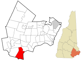
Location in Rockingham County and the state of New Hampshire.
|
||
| Country | United States | |
| State | New Hampshire | |
| County | Rockingham | |
| Incorporated | 1750 | |
| Villages |
|
|
| Area | ||
| • Total | 25.90 sq mi (67.07 km2) | |
| • Land | 24.84 sq mi (64.33 km2) | |
| • Water | 1.05 sq mi (2.73 km2) 4.07% | |
| Elevation | 131 ft (40 m) | |
| Population
(2020)
|
||
| • Total | 30,089 | |
| • Density | 1,209/sq mi (466.7/km2) | |
| Time zone | UTC−5 (Eastern) | |
| • Summer (DST) | UTC−4 (Eastern) | |
| ZIP Code |
03079
|
|
| Area code(s) | 603 | |
| FIPS code | 33-66660 | |
| GNIS feature ID | 0873713 | |
Salem is a town located in Rockingham County, New Hampshire, United States. In 2020, about 30,089 people lived there. Salem is just north of Boston and is found along Interstate 93.
Because New Hampshire does not have a state sales tax, Salem has become a big shopping area. Many people from the northern part of Greater Boston come here to shop. Key places for shopping include the Mall at Rockingham Park and Tuscan Village. Salem is also home to Canobie Lake Park, a large amusement park, and America's Stonehenge, an old stone structure. The Sununu family, known in New Hampshire politics, comes from Salem. This includes former Governor John H. Sununu and his sons, former U.S. Senator John E. Sununu and current Governor Chris Sununu.
In 2020, the Money website listed Salem as one of the "Best Places to Live."
Contents
A Look Back: Salem's History
Salem was first settled in 1652. Before it was called Salem, it was known as the "North Parish" of Methuen, Massachusetts. This was around 1736. In 1741, the border between Massachusetts and New Hampshire was officially set. The "North Parish" then became part of New Hampshire. It was named "Salem" after the nearby town of Salem, Massachusetts.
The town was officially created in 1750 by Governor Benning Wentworth. The original meetinghouse from 1738 is still standing. It used to be Salem's town hall and is now the Salem Historical Society museum.
Canobie Lake Park: A Fun History
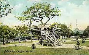
In 1902, Canobie Lake Park opened in Salem. It was started by a railway company to encourage people to ride their trolleys for fun trips. This idea worked very well! The park quickly became one of the most popular resorts in New England.
Many people came from nearby towns like Haverhill, Lawrence, and Lowell. Factory workers and others enjoyed walking along paths, seeing flower beds, and relaxing by the lake. There were also rides, arcades, and a dance hall for entertainment.
When cars became popular, trolleys were used less. But Canobie Lake Park is still open today and is very popular. It is one of the few old trolley amusement parks that still exist.
How Salem Grew and Changed
Starting in the 1950s, Salem began to grow quickly. It became part of the larger Greater Boston area. New neighborhoods and many shops were built, especially along NH Route 28. More recently, new businesses have also been built near Exit 2 on Interstate 93.
Since 2017, a large project called Tuscan Village has been under construction. This big development includes shops, medical offices, and homes. It is being built where the old Rockingham Park race track used to be.
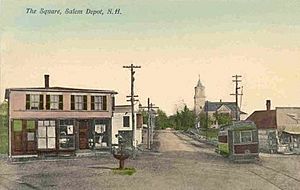
A railroad line, the Manchester and Lawrence Railroad, used to run through Salem until 2001. There have been talks about bringing back train service for commuters to Boston, but no action has been taken yet.
Geography: Where is Salem?
Salem covers about 67.1 square kilometers (25.9 square miles). Most of this area is land, with about 2.7 square kilometers (1.0 square mile) being water. The town has several bodies of water, including Canobie Lake, Arlington Mill Reservoir, and World End Pond. The Spicket River also flows through Salem.
The highest point in Salem is Gordon's Hill, which is about 116 meters (380 feet) above sea level.
Salem's Location on Interstate 93
Salem is the first town you reach in New Hampshire when driving north from Massachusetts on Interstate 93. There are two exits for Salem on I-93. From Salem, Boston is about 56 kilometers (35 miles) south, and Manchester is about 32 kilometers (20 miles) northwest.
Neighboring Towns and Cities
Salem shares its borders with several other towns and cities:
- Derry, New Hampshire (north)
- Atkinson, New Hampshire (northeast)
- Haverhill, Massachusetts (east)
- Methuen, Massachusetts (south)
- Pelham, New Hampshire (southwest)
- Windham, New Hampshire (west)
Population: Who Lives in Salem?
Salem has grown quite a bit over the years. In 2000, there were 28,112 people living in the town. Most people in Salem are White (95.01%), with smaller percentages of Asian (2.27%), African American (0.55%), and Native American (0.21%) residents. About 1.96% of the population was Hispanic or Latino.
The average household in Salem had about 2.69 people. Many households (60.6%) were married couples living together. The median age in Salem was 38 years old. This means half the people were younger than 38 and half were older.
Education: Schools and Learning
Salem's public schools spend about $5,544 per student each year. On average, there are about 16.1 students for every teacher in Salem.
Colleges and High Schools
- Southern New Hampshire University has a campus in Salem.
- The main high school is Salem High School.
Private Schools
- Saint Joseph Regional Catholic School is a private school in Salem.
Transportation: Getting Around Salem
Several important roads and highways pass through Salem. These include four New Hampshire state routes and one Interstate Highway.
- NH 28 runs through the center of Salem.
- NH 38 starts in Salem and goes southwest towards Pelham.
- NH 97 also starts in Salem and goes east to Haverhill, Massachusetts.
- NH 111 crosses the northern part of town.
- Interstate 93 goes through Salem from southeast to northwest, with two exits in town.
The closest airport is Manchester–Boston Regional Airport. For train travel, the nearest commuter rail service is the Haverhill Line of the MBTA Commuter Rail in Lawrence, Massachusetts. The closest Amtrak station is in Haverhill, Massachusetts.
Notable People from Salem
Many interesting people have connections to Salem:
- Daryl Abbas: A state senator in New Hampshire.
- Artosis (Daniel Stemkoski): A well-known commentator for the video game StarCraft.
- Pamela Gidley: An actress and model.
- Katie King-Crowley: A former U.S. Women's Ice Hockey Olympian and current coach.
- Duffy Lewis: A former Major League Baseball player.
- Chuck Morse: The president of the New Hampshire State Senate.
- Wallace Stickney: A former director of the Federal Emergency Management Agency (FEMA).
- Chris Sununu: The current (82nd) governor of New Hampshire.
- John E. Sununu: A former U.S. congressman and senator.
- John H. Sununu: A former governor of New Hampshire and White House Chief of Staff under President George H. W. Bush.
Fun Places to Visit in Salem
Salem has several interesting places that people enjoy visiting:
- America's Stonehenge: A mysterious stone structure.
- Canobie Lake Park: A popular amusement park with rides and games.
- Tuscan Village: A new shopping and living area built where the old Rockingham Park racetrack used to be.
- Mall at Rockingham Park: A large shopping mall.
- Manchester and Lawrence Railroad rail trail: A path for walking and biking along the old railroad line.
|
See also
 In Spanish: Salem (Nuevo Hampshire) para niños
 | Bessie Coleman |
 | Spann Watson |
 | Jill E. Brown |
 | Sherman W. White |


