Pelham, New Hampshire facts for kids
Quick facts for kids
Pelham, New Hampshire
|
||
|---|---|---|
|
Town
|
||

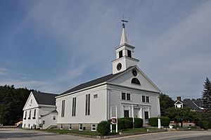
The Congregational church in the town center
|
||
|
||

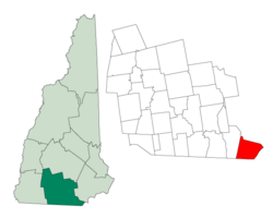
Location in Hillsborough County, New Hampshire
|
||
| Country | United States | |
| State | New Hampshire | |
| County | Hillsborough | |
| Incorporated | 1746 | |
| Named for | Thomas Pelham-Holles, 1st Duke of Newcastle | |
| Villages |
|
|
| Area | ||
| • Total | 26.9 sq mi (69.6 km2) | |
| • Land | 26.3 sq mi (68.2 km2) | |
| • Water | 0.5 sq mi (1.4 km2) 2.01% | |
| Elevation | 154 ft (47 m) | |
| Population
(2020)
|
||
| • Total | 14,222 | |
| • Density | 540/sq mi (208.4/km2) | |
| Time zone | UTC−5 (Eastern) | |
| • Summer (DST) | UTC−4 (Eastern) | |
| ZIP code |
03076
|
|
| Area code(s) | 603 | |
| FIPS code | 33-59940 | |
| GNIS feature ID | 0873695 | |
Pelham is a town in Hillsborough County, New Hampshire, USA. In 2020, about 14,222 people lived there. This was more than the 12,897 people in 2010. Pelham is part of the Merrimack Valley region.
Contents
History of Pelham
Pelham became its own town in 1741. This happened when the border between Massachusetts and New Hampshire was finally decided. The town was officially formed in 1746. It was named after Thomas Pelham-Holles, 1st Duke of Newcastle, a famous person from that time.
Geography and Location
Pelham is located in southern New Hampshire. It's in the very southeastern corner of Hillsborough County. It is the southernmost town in New Hampshire. It's also the easternmost town in its county.
Pelham is about 7 miles (11 km) north of Lowell, Massachusetts. It's also 9 miles (14 km) west of Lawrence, Massachusetts. And it's 9 miles (14 km) east of Nashua, New Hampshire.
State's Southernmost Point
Pelham holds the southernmost point in New Hampshire. This spot is known as the "Old Boundary Pine." It was named after a pine tree that once marked the border. This point is 3 miles (5 km) north of Pawtucket Falls in Lowell. It's where the straight border line meets a 3-mile buffer from the Merrimack River.
Land and Water
The town of Pelham covers a total area of about 26.9 square miles (69.6 square kilometers). Most of this area, about 26.3 square miles (68.2 square kilometers), is land. The remaining 0.5 square miles (1.4 square kilometers), or 2.01%, is water.
Most of Pelham's water drains into Beaver Brook. This brook flows south into the Merrimack River in Lowell, Massachusetts. Some small parts of the town on its eastern side drain into other small streams that also flow into the Merrimack River.
The highest point in Pelham is Jeremy Hill. It stands about 577 feet (176 meters) above sea level. This hill is located near the town's western border.
Neighboring Towns
Pelham shares its borders with several other towns:
- To the north: Windham
- To the northeast: Salem
- To the east: Methuen, Massachusetts
- To the south: Dracut, Massachusetts
- To the southwest: Tyngsborough, Massachusetts
- To the west: Hudson
Population Changes
| Historical population | |||
|---|---|---|---|
| Census | Pop. | %± | |
| 1790 | 791 | — | |
| 1800 | 918 | 16.1% | |
| 1810 | 998 | 8.7% | |
| 1820 | 1,040 | 4.2% | |
| 1830 | 1,070 | 2.9% | |
| 1840 | 1,003 | −6.3% | |
| 1850 | 1,071 | 6.8% | |
| 1860 | 944 | −11.9% | |
| 1870 | 861 | −8.8% | |
| 1880 | 848 | −1.5% | |
| 1890 | 791 | −6.7% | |
| 1900 | 875 | 10.6% | |
| 1910 | 826 | −5.6% | |
| 1920 | 974 | 17.9% | |
| 1930 | 814 | −16.4% | |
| 1940 | 979 | 20.3% | |
| 1950 | 1,317 | 34.5% | |
| 1960 | 2,605 | 97.8% | |
| 1970 | 5,408 | 107.6% | |
| 1980 | 8,090 | 49.6% | |
| 1990 | 9,408 | 16.3% | |
| 2000 | 10,914 | 16.0% | |
| 2010 | 12,897 | 18.2% | |
| 2020 | 14,222 | 10.3% | |
| U.S. Decennial Census | |||
The first count of people in Pelham was in 1767. At that time, 543 people lived in the town. Over the years, Pelham's population has grown a lot. By 2020, it had reached 14,222 residents.
In 2000, there were 10,914 people living in Pelham. Most residents were White (97.34%). About 1.04% were Asian, and 0.44% were African American. About 0.96% of the population was Hispanic or Latino.
The average household in Pelham had about 3 people. Many households (43.6%) had children under 18 living with them. Most families (71.8%) were married couples. The median age in town was 36 years old. This means half the people were younger than 36 and half were older.
Education in Pelham

Public schools in Pelham are managed by the Pelham School District. This district covers the same area as the town. The superintendent, who is like the head of all the schools, is Dr. Chip McGee.
The schools in Pelham are:
- Pelham Elementary School
- Principal: Jessica VanVranken
- Assistant Principals: Kelly LaBonte and Kerry Struth
- Pelham Memorial School
- Principal: Zack Medlock
- Assistant Principal: Todd Kress
- Pelham High School
- Principal: Dawn Mead
- Assistant Principal: Adam Barriere
There used to be a private school called St. Patrick School in town.
Getting Around Pelham
Three main New Hampshire state roads pass through Pelham:
- NH 38 comes into town from Massachusetts in the south. It then curves northeast and leaves Pelham into Salem. This road, also known as Bridge Street, is a busy area for businesses in Pelham.
- NH 111A starts near the Massachusetts border. It goes mostly northeast and exits into Windham. In Pelham, it's called Marsh Road and Windham Road.
- NH 128 is part of the larger Mammoth Road. This road connects Lowell, Massachusetts, to Hooksett, New Hampshire. It enters Pelham from the Massachusetts border and goes straight north. It runs along the western edge of town before going into Windham.
Nearby Highways and Transportation
The closest major highway is Interstate 93. You can get to it about 6 miles (10 km) northeast of Pelham's center in Salem. Pelham is even mentioned on the signs for Exit 2 on that highway.
The U.S. Route 3 freeway, which goes through Nashua, is about 8 miles (13 km) west of Pelham's center. Interstate 495 in Massachusetts is also easy to reach. It's about 9 miles (14 km) south of Pelham, near Lowell, and 10 miles (16 km) east, near Methuen.
Pelham itself does not have an airport or train service. The nearest commercial airport is Manchester–Boston Regional Airport. It's located near Londonderry and Manchester. For train service, you can use the Lowell Line of the MBTA Commuter Rail. You can catch this train in Lowell or Lawrence. The closest Amtrak station is Haverhill Station in Haverhill, Massachusetts.
Parks and Recreation
Muldoon Park
Muldoon Park is located northwest of the center of Pelham. You can find it at 305 Mammoth Road (NH 128), just north of Nashua Road.
Muldoon Park has many short walking trails. It also has four different sized baseball fields, from t-ball to official fields. There's a soccer field and a play area too. Most of the trails lead to the park's two ponds, nearby roads, houses, or to Beaver Brook, which is a small river.
In September 2007, the town of Pelham finished building an 18-hole disc golf course here. It stretches over a quarter-mile. The Pelham Parks and Recreation department also added two more baseball fields recently. Many players from nearby towns enjoy playing disc golf in the woods next to the sports fields.
Famous People from Pelham
Pelham has been home to several notable people:
- Josiah Butler (1779–1854): He was a US congressman.
- Sean Caisse (born 1986): A professional stock car driver.
- Ray Fox (1916–2014): A famous crew chief and owner in NASCAR.
- Daniel Gage (1828–1901): Known as the "Ice King of Lowell." Gage Hill is named after his family.
- Nick Groff (born 1980): A paranormal investigator who graduated from Pelham High School in 1999.
- Richard M. Linnehan (born 1957): An astronaut for NASA who graduated from Pelham High School in 1975.
See also
 In Spanish: Pelham (Nuevo Hampshire) para niños
 | Chris Smalls |
 | Fred Hampton |
 | Ralph Abernathy |


