Dracut, Massachusetts facts for kids
Quick facts for kids
Dracut, Massachusetts
|
||
|---|---|---|

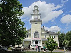
Christ Church United
|
||
|
||

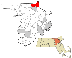
Location in Middlesex County in Massachusetts
|
||
| Country | United States | |
| State | Massachusetts | |
| County | Middlesex | |
| Settled | 1653 | |
| Incorporated | 1701 | |
| Government | ||
| • Type | Open town meeting | |
| Area | ||
| • Total | 21.36 sq mi (55.32 km2) | |
| • Land | 20.9 sq mi (54.1 km2) | |
| • Water | 0.5 sq mi (1.2 km2) | |
| Elevation | c. 156 ft (c. 48 m) | |
| Population
(2020)
|
||
| • Total | 32,617 | |
| • Density | 1,560.6/sq mi (602.6/km2) | |
| • Demonym | Dracuteer | |
| Time zone | UTC−5 (Eastern) | |
| • Summer (DST) | UTC−4 (Eastern) | |
| ZIP Code |
01826
|
|
| Area code(s) | 978 & 351 | |
| FIPS code | 25-17475 | |
| GNIS feature ID | 0618221 | |
Dracut /ˈdreɪkət/ is a town in Middlesex County, Massachusetts, in the United States. In 2020, about 32,617 people lived there. This made it the second largest town in Massachusetts that uses an open town meeting system of government. In this system, citizens can directly vote on town matters. Dracut covers about 21.36 square miles, with a small part (0.5 square miles) being water.
Contents
Dracut's Story: A Look at Its History
Before Europeans arrived in the mid-1600s, the area now known as Dracut was called Augumtoocooke. Pennacook Native American groups lived here. They found good fishing at Pawtucket Falls on the Merrimack River. The nearby marsh areas also had lots of animals for hunting. A powerful leader named Passaconaway and his family lived on this land from the late 1500s to the mid-1600s.
Early European Settlers
Around 1653, Europeans began to settle in the area. They created the town of Chelmsford in 1655. Chelmsford was on the other side of the Merrimack River from where Dracut is today.
In 1665, a woman named Bess, who was Passaconaway's daughter, sold the Augumtoocooke land. She sold it to Captain John Evered, also known as Webb. He was from a place called Draucutt in England. Webb had already sold some of this land to Samuel Varnum in 1664, even though he didn't own it yet.
Edward Colburn and his family were likely the first settlers in Dracut who bought land to live on permanently. Samuel Varnum lived on the Chelmsford side of the river.
Becoming Its Own Town
Even though the new settlers called this area Dracut (Draucutt), they were across the Merrimack River from Chelmsford's town center. They agreed to pay taxes to Chelmsford and relied on them for protection. However, by 1669, protecting the settlers in Dracut became too hard and costly for Chelmsford.
In 1676, the Wamesit Indians burned down four of Edward Colburn's buildings. They also attacked Samuel Varnum and his family as they crossed the river. Two of Samuel's sons were killed.
Because of these dangers and a lack of protection, families like the Varnums and Colburns living in Dracut wanted their own town. They asked the government to make Dracut a separate township. They explained that about 20 families lived there, and it was hard for their children to go to church in Chelmsford because it was so far away. They believed making Dracut a town would help the people and strengthen the area.
Their request was approved! Dracut officially became its own town on February 26, 1701.
Dracut's Growth and Changes
Some parts of Dracut were once a "Praying Town." These were special areas set aside by colonists for Native Americans who had become Christians.
Dracut has several large ponds, wet areas, and many small streams, like Beaver Brook. In its early days, Dracut's economy depended on fishing, cutting timber, and milling. Later, in the 1800s, industries like paper making and cotton textile factories, such as the Beaver Brook Mill, became important. These mills brought many Irish and French-Canadian immigrants to Dracut.
Today, Dracut has seen a lot of new homes built as people move from nearby Lowell. In the 1800s, Lowell actually took over large parts of Dracut. Still, some rural areas and beautiful old houses remain. One famous old house is the Colburn/Cutter House, which is about 290 years old. It has huge beams and big fireplaces. This building has hosted the annual Dracut Craft Fair. Dracut also holds an annual Old Home Day every September, which started in 2001. As of 2020, Dracut is the only town in the world with its exact name and spelling!
Dracut's Location and Features
Dracut covers about 21.4 square miles. Most of this is land (20.9 square miles), and a small part (0.5 square miles) is water.
Dracut is located in the Merrimack Valley of Massachusetts. It's about 30 miles northwest of Boston, the state capital.
The southern part of Dracut is along the Merrimack River. The town is also divided by Beaver Brook.
Town Districts
Dracut has nine special Business Districts. These districts often share names with historic neighborhoods in town. Each district has signs with its name and a special symbol.
The districts are: Bridge Street, Broadway, Collinsville, Dracut Center, East Dracut, Hovey Square, Kenwood, Lakeview, and Navy Yard Districts.
Neighboring Towns
Dracut shares borders with several other towns:
- To the west: Tyngsboro
- To the south and west: Lowell
- To the east: Methuen (in Essex County)
- To the north: Pelham, New Hampshire
Tewksbury and Andover are also near Dracut, across the Merrimack River to the south. There are no direct bridges from Dracut to Tewksbury or Andover. To get there, you usually have to go through Lowell or use I-93 in Methuen.
Who Lives in Dracut?
| Historical population | ||
|---|---|---|
| Year | Pop. | ±% |
| 1790 | 1,217 | — |
| 1800 | 1,274 | +4.7% |
| 1810 | 1,301 | +2.1% |
| 1820 | 1,407 | +8.1% |
| 1830 | 1,615 | +14.8% |
| 1840 | 2,188 | +35.5% |
| 1850 | 3,503 | +60.1% |
| 1860 | 1,881 | −46.3% |
| 1870 | 2,078 | +10.5% |
| 1880 | 1,595 | −23.2% |
| 1890 | 1,996 | +25.1% |
| 1900 | 3,253 | +63.0% |
| 1910 | 3,461 | +6.4% |
| 1920 | 5,280 | +52.6% |
| 1930 | 6,912 | +30.9% |
| 1940 | 7,339 | +6.2% |
| 1950 | 8,666 | +18.1% |
| 1960 | 13,674 | +57.8% |
| 1970 | 18,214 | +33.2% |
| 1980 | 21,249 | +16.7% |
| 1990 | 25,594 | +20.4% |
| 2000 | 28,562 | +11.6% |
| 2010 | 29,457 | +3.1% |
| 2020 | 32,617 | +10.7% |
| 2022* | 32,060 | −1.7% |
| * = population estimate. Source: United States Census records and Population Estimates Program data. |
||
The first census data from 1765 showed that 1,173 people lived in Dracut.
In 2010, about 29,457 people lived in Dracut. There were 10,451 households, with an average of 2.69 people per home. About 35.3% of households had children under 18 living with them.
The median age in Dracut was about 41.1 years. About 25.5% of the population was under 18 years old.
Schools in Dracut
Dracut has a public school system with six schools:
- One high school
- One middle school (for grades 6–8)
- Four elementary schools (for grades K–5)
Here are the schools and how many students they had in the 2020–2021 school year:
- Dracut Senior High School (889 students)
- Richardson Middle School (920 students)
- Englesby Elementary School (544 students)
- Brookside Elementary School (444 students)
- Campbell Elementary School (579 students)
- Greenmont Elementary School (283 students)
The former Parker Elementary School is also used for some special education programs. Many Dracut students also attend the Greater Lowell Technical High School.
Getting Around Dracut
Dracut is close to several major highways. These include Interstate 93, Interstate 495, and U.S. Route 3. Route 38, Route 110, and Route 113 also go directly through the town.
The LRTA 10 bus connects to the Lowell train station. From there, you can take the MBTA Commuter Rail's Lowell Line train.
Famous People from Dracut
Many interesting people have connections to Dracut:
- Wendell Corey, an actor
- Scott Grimes, an actor
- Harry Lew, a professional basketball player
- Lucy Lew, an early leader for African American rights
- Roger Morin, a Bishop
- John Ogonowski (1951–2001), an airline pilot who was flying American Airlines Flight 11 on 9/11 before it was hijacked
- James Mitchell Varnum, a lawyer and general during the American Revolution
- Joseph Bradley Varnum, a politician
See also
 In Spanish: Dracut (Massachusetts) para niños
 | Delilah Pierce |
 | Gordon Parks |
 | Augusta Savage |
 | Charles Ethan Porter |


