Hooksett, New Hampshire facts for kids
Quick facts for kids
Hooksett, New Hampshire
|
||
|---|---|---|
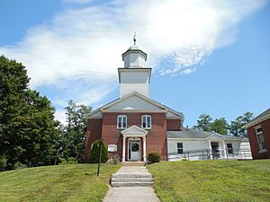
Hooksett Municipal Building
|
||
|
||
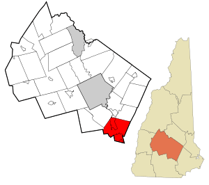
Location in Merrimack County and the state of New Hampshire
|
||
| Country | United States | |
| State | New Hampshire | |
| County | Merrimack | |
| Incorporated | 1822 | |
| Villages |
|
|
| Area | ||
| • Total | 37.1 sq mi (96.2 km2) | |
| • Land | 36.1 sq mi (93.4 km2) | |
| • Water | 1.1 sq mi (2.8 km2) 2.88% | |
| Elevation | 213 ft (65 m) | |
| Population
(2020)
|
||
| • Total | 14,871 | |
| • Density | 412/sq mi (159.2/km2) | |
| Time zone | UTC−5 (Eastern) | |
| • Summer (DST) | UTC−4 (Eastern) | |
| ZIP code |
03106
|
|
| Area code(s) | 603 | |
| FIPS code | 33-37300 | |
| GNIS feature ID | 0873629 | |
Hooksett is a town in New Hampshire, USA, located in Merrimack County. In 2020, about 14,871 people lived there. This was more than the 13,451 residents counted in 2010.
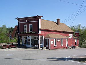
The town is located between Manchester, which is the biggest city in New Hampshire, and Concord, the state capital. A famous place in Hooksett is Robie's Country Store. It's a National Historic Landmark and a popular stop for people running for president during the New Hampshire primary election.
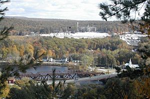
The main village in town is also called Hooksett. About 5,283 people lived there in 2020. This village is located where a bridge crosses the Merrimack River. The town also includes another area called South Hooksett.
Contents
History of Hooksett
Hooksett became an official town in 1822. Before that, it was known by names like "Chester Woods" and "Rowe's Corner". The community was called "Hooksett" for almost 50 years before it was officially recognized as a town.
The name "Hooksett" might have come from a hook-shaped island in the Merrimack River. Or, it could be from early fishermen who called the area "Hookline Falls". The Merrimack River here has rocky ledges. In the past, there were several ferries to cross the river. There were also lumber mills and places that made bricks, all powered by the river's falls. The first count of people in 1830 showed 880 residents.
The very first settlement in this area was Martins Ferry. It was near the Merrimack River and where Southern New Hampshire University is today. The Martin family owned the ferry and the land for many years. Today, a place called Martin's Corner, about 1 mile (1.6 km) to the east, still has their name. In 1794, the Hooksett Canal was built. It helped transport goods for the Amoskeag cotton mills in Manchester.
Geography of Hooksett
Hooksett is located on the Merrimack River in the southern-central part of New Hampshire. Interstate 93 is a major highway that connects Hooksett to the White Mountains and Boston. All of Hooksett is within the watershed of the Merrimack River. This means all the rain and water in Hooksett eventually flows into the Merrimack River.
The town covers a total area of about 96.2 square kilometers (37.1 square miles). Of this, 93.4 square kilometers (36.1 square miles) is land. The remaining 2.8 square kilometers (1.1 square miles) is water, which is about 2.88% of the town's total area.
The highest point in Hooksett is Quimby Mountain. It is about 902 feet (275 meters) above sea level. This mountain is close to the town's western border. On the eastern side of town, a ridge goes up towards Hall Mountain in nearby Candia. This ridge reaches about 900 feet (274 meters) above sea level.
Neighboring Towns
Hooksett shares its borders with these towns:
- Allenstown (north)
- Deerfield (northeast)
- Candia (east)
- Auburn (southeast)
- Manchester (south)
- Goffstown (southwest)
- Dunbarton (west)
- Bow (northwest)
Population of Hooksett
| Historical population | |||
|---|---|---|---|
| Census | Pop. | %± | |
| 1830 | 880 | — | |
| 1840 | 1,175 | 33.5% | |
| 1850 | 1,503 | 27.9% | |
| 1860 | 1,257 | −16.4% | |
| 1870 | 1,330 | 5.8% | |
| 1880 | 1,766 | 32.8% | |
| 1890 | 1,893 | 7.2% | |
| 1900 | 1,665 | −12.0% | |
| 1910 | 1,528 | −8.2% | |
| 1920 | 1,828 | 19.6% | |
| 1930 | 2,132 | 16.6% | |
| 1940 | 2,273 | 6.6% | |
| 1950 | 2,792 | 22.8% | |
| 1960 | 3,713 | 33.0% | |
| 1970 | 5,564 | 49.9% | |
| 1980 | 7,303 | 31.3% | |
| 1990 | 8,767 | 20.0% | |
| 2000 | 11,721 | 33.7% | |
| 2010 | 13,451 | 14.8% | |
| 2020 | 14,871 | 10.6% | |
| U.S. Decennial Census | |||
According to the census from 2010, there were 13,451 people living in Hooksett. There were 4,926 households, which are groups of people living together in one home. About 3,533 of these were families. The population density was about 369 people per square mile (142.4 people per square kilometer).
Most of the people in Hooksett are White (94.6%). There are also smaller groups of African American (1.0%), Native American (0.2%), and Asian (2.0%) residents. About 2.1% of the population is Hispanic or Latino.
In 2010, about 22.4% of the people were under 18 years old. About 11.6% were 65 years or older. The average age in Hooksett was 39.8 years.
For more detailed information about the population in specific parts of Hooksett, you can look up Hooksett (CDP), New Hampshire and South Hooksett, New Hampshire.
Transportation in Hooksett
Several important roads and highways pass through Hooksett. These include five New Hampshire state routes, two Interstate Highways, and one U.S. route.
- NH 3A runs from south to north through Hooksett. It goes along the Merrimack River and parallel to I-93. Locals call it West River Road. It connects Manchester to Bow.
- NH 27 starts in Hooksett at NH 28/US 3. It then goes east on Whitehall Road into Candia.
- NH 28 also crosses Hooksett from south to north. It shares its path with US 3. It is known as Hooksett Road, Daniel Webster Highway, and Allenstown Road. This route connects Manchester to Suncook.
- NH 28A comes from Manchester in the south. It follows Mammoth Road and ends where it meets NH 28/US3.
- NH 28 Bypass enters from the southeast, coming from Auburn. It follows Londonderry Turnpike and ends at NH 28/US 3.
- Interstate 93 is a major highway that goes through Hooksett from south to north. It connects Manchester to Bow. There are three exits in Hooksett to get onto or off I-93. One is with NH 28/US 3 in South Hooksett. Another is with NH 3A after crossing the Merrimack River. The third is with Hackett Hill Road in northern Hooksett, which also leads to NH 3A. There's also a connection to I-293. The part of I-93 north of I-293 is called the F.E. Everett Turnpike. Hooksett also has a rest area and welcome center for travelers, near the border with Bow.
- Interstate 293 briefly enters Hooksett near the southern border with Manchester. It ends when it connects to I-93. This highway does not have any direct exits into Hooksett.
- US 3 crosses Hooksett from south to north. It runs together with NH 28. It is known as Hooksett Road, Daniel Webster Highway, and Allenstown Road. It connects Manchester to Suncook.
Education in Hooksett
Hooksett is part of School Administrative Unit 15 (SAU-15). This unit also includes the nearby towns of Auburn and Candia. SAU-15 manages five schools, and three of them are located in Hooksett:
- Fred C. Underhill School: This school is for younger elementary students, from Pre-Kindergarten to 2nd grade.
- Hooksett Memorial School: This school is for older elementary students, from 3rd to 5th grade.
- David R. Cawley Middle School: This school serves students in grades 6 through 8.
SAU-15 does not have its own high school. This means that students from Hooksett go to high schools in other nearby school districts. As of 2014, most high school students from Hooksett (about 650 of them) attend Pinkerton Academy. A smaller number of students go to Bow High School (about 40 students), Pembroke Academy (about 10 students), or Londonderry High School (about 160 students). Before 2014, Hooksett students went to high schools in the Manchester School District in the city of Manchester. Students can still choose to attend Manchester schools if they wish.
One four-year university, Southern New Hampshire University, is located partly in Hooksett and partly in Manchester.
See also
 In Spanish: Hooksett (Nuevo Hampshire) para niños
 | Audre Lorde |
 | John Berry Meachum |
 | Ferdinand Lee Barnett |


