Hooksett (CDP), New Hampshire facts for kids
Quick facts for kids
Hooksett, New Hampshire
|
|
|---|---|

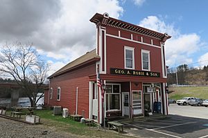
Geo. A. Robie and Son, Hooksett NH.jpg
|
|
| Country | United States |
| State | New Hampshire |
| County | Merrimack |
| Town | Hooksett |
| Area | |
| • Total | 5.84 sq mi (15.13 km2) |
| • Land | 5.40 sq mi (13.98 km2) |
| • Water | 0.44 sq mi (1.15 km2) |
| Elevation | 210 ft (60 m) |
| Population
(2020)
|
|
| • Total | 5,283 |
| • Density | 978.51/sq mi (377.83/km2) |
| Time zone | UTC-5 (Eastern (EST)) |
| • Summer (DST) | UTC-4 (EDT) |
| ZIP code |
03106
|
| Area code(s) | 603 |
| FIPS code | 33-37220 |
| GNIS feature ID | 2378073 |
Hooksett is a special area in New Hampshire, United States. It is called a census-designated place (CDP). This means it is a place that the government counts for population, but it is not a separate city or town. Hooksett CDP is part of the larger town of Hooksett.
The CDP includes the old central village of Hooksett. It also has suburban and rural areas around it. In 2020, about 5,283 people lived in the Hooksett CDP. The entire town of Hooksett had a population of 14,871 people.
Contents
Exploring Hooksett's Location
Hooksett CDP is located in the middle to northern parts of the town of Hooksett. It sits on both sides of the Merrimack River. The main village of Hooksett is right in the center. Here, Main Street crosses the Merrimack River.
Borders and Nearby Places
The CDP stretches north to the town lines of Bow and Allenstown. To the south, it includes the Granite Hill Villages housing area. Interstate 93 forms the western edge of the CDP. You can get onto I-93 from Exit 11 at the Hooksett toll plaza. U.S. Route 3 runs through the eastern side of the CDP.
New Hampshire Route 3A goes through the center of the CDP. It follows the west side of the Merrimack River. Hooksett is next to the Suncook CDP in Allenstown to the north.
Distance to Major Cities
Concord is the state capital. It is about 9 miles (14 km) north of Hooksett via I-93 or NH 3A. It is about 10 miles (16 km) north via US 3. Manchester is the largest city in New Hampshire. It is about 8 miles (13 km) south of Hooksett.
Land and Water Areas
The Hooksett CDP covers a total area of about 5.84 square miles (15.1 square kilometers). Most of this area is land, about 5.40 square miles (14.0 square kilometers). The rest is water, which is about 0.44 square miles (1.1 square kilometers). This means about 7.60% of the CDP's area is water.
Who Lives in Hooksett?
This section looks at the people who live in Hooksett CDP. It covers how many people live there and what groups they belong to.
| Historical population | |||
|---|---|---|---|
| Census | Pop. | %± | |
| 1970 | 1,303 | — | |
| 1980 | 1,868 | 43.4% | |
| 1990 | 2,573 | 37.7% | |
| 2000 | 3,609 | 40.3% | |
| 2010 | 4,147 | 14.9% | |
| 2020 | 5,283 | 27.4% | |
| U.S. Decennial Census | |||
Population Changes Over Time
The population of Hooksett CDP has grown a lot over the years. In 1970, there were only 1,303 people. By 2020, the population had grown to 5,283 people. This shows that more and more people are choosing to live in Hooksett.
People and Households in 2010
In 2010, there were 4,147 people living in the CDP. These people lived in 1,819 households. A household is a group of people living together in one home. There were also 1,945 housing units, like houses or apartments. Only 126 of these were empty.
Most people in Hooksett CDP were white (93.9%). Other groups included African American (1.6%), Asian (1.8%), and Native American (0.1%). About 2.3% of the people were Hispanic or Latino.
Family Life in Hooksett
About 27.3% of households had children under 18 living with them. Nearly half of the households (49.1%) were married couples living together. About 10.8% of households had a female head with no husband present. About 35.9% were non-family households. This means they were not related by blood, marriage, or adoption.
About 26.7% of all households were made up of just one person. About 8.4% of these were people aged 65 or older living alone. The average household had 2.28 people. The average family had 2.75 people.
Age Groups and Income
In 2010, about 19.7% of residents were under 18 years old. About 14.9% were 65 years or older. The median age was 41.9 years. This means half the people were older than 41.9 and half were younger.
From 2011 to 2015, the estimated average yearly income for a household was about $68,294. For families, it was about $74,658. The average income per person in the CDP was $32,689. A small number of people (3.8%) and families (1.8%) lived below the poverty line.
See also

- In Spanish: Hooksett (condado de Merrimack) para niños


