Allenstown, New Hampshire facts for kids
Quick facts for kids
Allenstown, New Hampshire
|
||
|---|---|---|

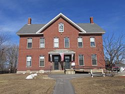
Allenstown Municipal Building
|
||
|
||

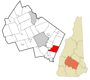
Location in Merrimack County and the state of New Hampshire.
|
||
| Country | United States | |
| State | New Hampshire | |
| County | Merrimack | |
| Incorporated | 1831 | |
| Villages | Allenstown Suncook (part) |
|
| Area | ||
| • Total | 20.6 sq mi (53.3 km2) | |
| • Land | 20.5 sq mi (53.0 km2) | |
| • Water | 0.1 sq mi (0.3 km2) 0.55% | |
| Elevation | 340 ft (100 m) | |
| Population
(2020)
|
||
| • Total | 4,707 | |
| • Density | 230/sq mi (88.8/km2) | |
| Time zone | UTC-5 (Eastern) | |
| • Summer (DST) | UTC-4 (Eastern) | |
| ZIP code |
03275
|
|
| Area code(s) | 603 | |
| FIPS code | 33-00660 | |
| GNIS feature ID | 0873528 | |
Allenstown is a small town in Merrimack County, New Hampshire, in the United States. In 2020, about 4,707 people lived there. This was more than the 4,322 people who lived there in 2010.
A part of the village called Suncook is also in Allenstown. More than half of Allenstown is covered by a big park called Bear Brook State Park.
Contents
History of Allenstown
Allenstown got its name from a governor named Samuel Allen. He lived in the 1600s. The land was first given out in 1721. But it didn't officially become a town until July 2, 1831.
Over time, parts of nearby towns were added to Allenstown. A piece of Bow was added in 1815. Later, in 1853, a part of Hooksett also joined Allenstown.
Early Settlement and Growth
The first people to settle in Allenstown lived in the eastern part of town. This was along Deerfield Road. Today, much of this area is part of Bear Brook State Park. The Old Allenstown Meeting House is also located there.
After the Civil War, more people started moving to the western part of town. This area was near where the Merrimack and Suncook rivers meet. This area is now known as Suncook.
Railroads and Mills
Railroads were very important for Allenstown's growth. The first railroad, the Concord and Portsmouth Railroad, arrived in 1852. It connected Allenstown to places further east.
Later, new rail lines were built. The Suncook Valley Railroad opened in 1869. It ran northeast along the Suncook River. It went to towns like Pittsfield. Even though the main Suncook train station was in Pembroke, Allenstown got its own station.
In 1902, an electric railway came to town. It connected Concord and Manchester. This made it easier for people to travel.
Allenstown was a great place for factories. This was because the Suncook River could power machines. The China Mill, a large textile mill (a factory that makes cloth), was built in 1868.
Many French Canadians came from Quebec to work in these mills. Because of this, Suncook became known as "le petit Canada" to many local people.
The Mother's Day Flood
In 2006, Allenstown had a very bad flood. It was called the "Mother's Day Flood." More than 10 inches (25 cm) of rain fell. This caused the Suncook River to overflow its banks.
Many homes, roads, and low-lying areas were flooded. To prevent future problems, 14 homes that were often flooded were bought by the government. They were then taken down. This helped keep people safer from future floods.
Geography of Allenstown
Allenstown covers about 53.3 square kilometers (20.6 sq mi). Most of this is land, about 53.0 square kilometers (20.5 sq mi). A small part, about 0.3 square kilometers (0.1 sq mi), is water. Water makes up about 0.55% of the town.
The highest point in Allenstown is Bear Hill. It is in the southeastern part of town. Bear Hill is about 340 meters (835 ft) above sea level. All of Allenstown is in the Merrimack River watershed. This means all the water in Allenstown eventually flows into the Merrimack River.
The Merrimack River forms the western edge of the town. The Suncook River, which flows into the Merrimack, forms the northwest edge.
Bear Brook State Park
Bear Brook State Park is a very large park. It covers about 6,740 acres (27.3 km²) within Allenstown. It stretches from the northern to the southern parts of the town.
The park also extends into nearby towns. These include Deerfield, Candia, and Hooksett.
Neighboring Towns
Allenstown shares its borders with these towns:
Population Information
| Historical population | |||
|---|---|---|---|
| Census | Pop. | %± | |
| 1790 | 254 | — | |
| 1800 | 315 | 24.0% | |
| 1810 | 346 | 9.8% | |
| 1820 | 433 | 25.1% | |
| 1830 | 421 | −2.8% | |
| 1840 | 455 | 8.1% | |
| 1850 | 526 | 15.6% | |
| 1860 | 414 | −21.3% | |
| 1870 | 804 | 94.2% | |
| 1880 | 1,707 | 112.3% | |
| 1890 | 1,475 | −13.6% | |
| 1900 | 1,496 | 1.4% | |
| 1910 | 1,457 | −2.6% | |
| 1920 | 1,213 | −16.7% | |
| 1930 | 1,549 | 27.7% | |
| 1940 | 1,673 | 8.0% | |
| 1950 | 1,540 | −7.9% | |
| 1960 | 1,789 | 16.2% | |
| 1970 | 2,732 | 52.7% | |
| 1980 | 4,398 | 61.0% | |
| 1990 | 4,649 | 5.7% | |
| 2000 | 4,843 | 4.2% | |
| 2010 | 4,322 | −10.8% | |
| 2020 | 4,707 | 8.9% | |
| U.S. Decennial Census | |||
In 2000, there were 4,843 people living in Allenstown. The average age of people in the town was 36 years old. For every 100 females, there were about 93.7 males.
Transportation
Two main roads pass through Allenstown. One is a New Hampshire state route. The other is a U.S. route.
- NH 28 comes into Allenstown with US 3. This happens in the village of Suncook. It then follows Pinewood Road north. It crosses into the town of Pembroke.
- US 3 also enters with NH 28 in Suncook. It is known as Allenstown Road. It then crosses the Suncook River into Pembroke.
See also
 In Spanish: Allenstown (Nuevo Hampshire) para niños
 | Misty Copeland |
 | Raven Wilkinson |
 | Debra Austin |
 | Aesha Ash |


