Epsom, New Hampshire facts for kids
Quick facts for kids
Epsom, New Hampshire
|
||
|---|---|---|

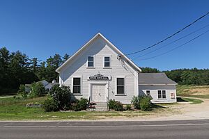
Epsom Town Hall, listed on the New Hampshire State Register of Historic Places
|
||
|
||

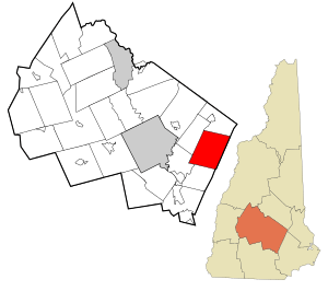
Location in Merrimack County and the state of New Hampshire
|
||
| Country | United States | |
| State | New Hampshire | |
| County | Merrimack | |
| Incorporated | 1727 | |
| Villages |
|
|
| Area | ||
| • Total | 34.61 sq mi (89.65 km2) | |
| • Land | 34.42 sq mi (89.14 km2) | |
| • Water | 0.20 sq mi (0.51 km2) 0.57% | |
| Elevation | 404 ft (123 m) | |
| Population
(2020)
|
||
| • Total | 4,834 | |
| • Density | 140/sq mi (54.2/km2) | |
| Time zone | UTC-5 (Eastern) | |
| • Summer (DST) | UTC-4 (Eastern) | |
| ZIP code |
03234
|
|
| Area code(s) | 603 | |
| FIPS code | 33-24900 | |
| GNIS feature ID | 0873592 | |
Epsom is a friendly town located in Merrimack County, New Hampshire, in the United States. It's a place where about 4,834 people live, according to the 2020 census. Epsom is known for its beautiful natural areas and a strong community spirit.
Contents
History of Epsom
Epsom became an official town in 1727. It got its name from a town called Epsom in Surrey, England. Even though Epsom, New Hampshire, has some small mountains, its land was good for raising animals like cows and growing crops such as grain.
By the year 1859, Epsom had a population of 1,366 people. The town was busy with two gristmills, which ground grain into flour. It also had two sawmills, which cut wood into lumber. These mills were very important for the town's economy back then.
Geography and Nature
Epsom is located in the central part of New Hampshire. It sits in the eastern area of Merrimack County. The eastern edge of Epsom touches the border of Rockingham County.
The state capital, Concord, is about 11 miles (18 km) to the west of Epsom. You can get there by taking U.S. Route 4. If you travel east on the same highway for about 34 miles (55 km), you'll reach Portsmouth on New Hampshire's coast.
Land and Water
Epsom covers a total area of about 89.7 square kilometers (34.6 square miles). Most of this area, about 89.1 square kilometers (34.4 square miles), is land. The rest, about 0.5 square kilometers (0.2 square miles), is water. This means water makes up about 0.57% of the town's total area.
The town has two important rivers: the Suncook River and its smaller branch, the Little Suncook River. These rivers help drain the land. Epsom is also part of the larger Merrimack River watershed. A watershed is an area of land where all the water drains into a common river or lake.
Mountains in Epsom
The highest point in Epsom is the top of Fort Mountain. It stands about 1,413 feet (431 meters) above sea level. You can find Fort Mountain in the eastern part of town. Other smaller mountains in Epsom include McCoy Mountain, which is about 1,270 feet (387 meters) tall, and Nats Mountain, which is about 1,180 feet (360 meters) tall.
Neighboring Towns
Epsom shares its borders with several other towns:
- Pittsfield (to the north)
- Northwood (to the northeast)
- Deerfield (to the east)
- Allenstown (to the south)
- Pembroke (to the southwest)
- Chichester (to the west)
Population Over Time
| Historical population | |||
|---|---|---|---|
| Census | Pop. | %± | |
| 1790 | 799 | — | |
| 1800 | 1,034 | 29.4% | |
| 1810 | 1,156 | 11.8% | |
| 1820 | 1,336 | 15.6% | |
| 1830 | 1,408 | 5.4% | |
| 1840 | 1,205 | −14.4% | |
| 1850 | 1,366 | 13.4% | |
| 1860 | 1,216 | −11.0% | |
| 1870 | 993 | −18.3% | |
| 1880 | 909 | −8.5% | |
| 1890 | 815 | −10.3% | |
| 1900 | 771 | −5.4% | |
| 1910 | 725 | −6.0% | |
| 1920 | 655 | −9.7% | |
| 1930 | 678 | 3.5% | |
| 1940 | 797 | 17.6% | |
| 1950 | 756 | −5.1% | |
| 1960 | 1,002 | 32.5% | |
| 1970 | 1,469 | 46.6% | |
| 1980 | 2,743 | 86.7% | |
| 1990 | 3,591 | 30.9% | |
| 2000 | 4,021 | 12.0% | |
| 2010 | 4,566 | 13.6% | |
| 2020 | 4,834 | 5.9% | |
| U.S. Decennial Census | |||
Epsom's population has changed a lot over the years. In 1790, there were 799 people living in the town. The population grew steadily for a while, reaching over 1,400 by 1830. Then, it slowly decreased for many years, falling to 655 people by 1920.
However, since the mid-20th century, Epsom has seen a lot of growth. The population has increased significantly, reaching 4,834 people by the 2020 census. This shows that more and more people are choosing to make Epsom their home.
Getting Around Epsom
Several important roads help people travel through Epsom. These include three New Hampshire state routes and two U.S. routes.
- NH 9, U.S. Route 4, and U.S. Route 202 all run together through the town. They connect Chichester in the west to Northwood in the east. Locally, this road is known as Dover Road.
- NH 28 crosses the western part of Epsom. It generally follows along the Suncook River. This route connects Pembroke to Chichester and is called Suncook Valley Road.
- NH 107 enters Epsom from Deerfield, near Northwood Lake. It then joins NH 9, US 4, and US 202, meaning all four routes share the same road for a bit before entering Northwood. NH 107 follows North Road before joining the other routes.
Famous People from Epsom
Epsom has been home to several notable individuals who achieved great things:
- John Dolbeer (1827–1902): He was an inventor and a business owner.
- Noah Martin (1801–1863): A doctor who later became the 30th governor of New Hampshire.
- Andrew McClary (1730–1775): He was a high-ranking officer who bravely fought in the Battle of Bunker Hill during the American Revolutionary War. A place called Fort McClary in Kittery, Maine, is named in his honor.
- John B. Sanborn (1826–1904): A lawyer who served as a brigadier general during the Civil War. He also represented Minnesota as a state representative.
- Walter Henry Sanborn (1845–1928): He became a U.S. federal judge.
See also
 In Spanish: Epsom (Nuevo Hampshire) para niños
 | Leon Lynch |
 | Milton P. Webster |
 | Ferdinand Smith |


