Northwood, New Hampshire facts for kids
Quick facts for kids
Northwood, New Hampshire
|
|
|---|---|

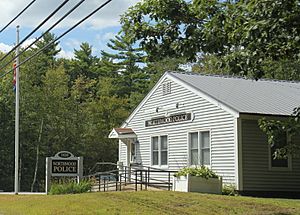
Northwood Police Station
|
|

Location in Rockingham County and the state of New Hampshire
|
|
| Country | United States |
| State | New Hampshire |
| County | Rockingham |
| Incorporated | 1773 |
| Villages |
|
| Area | |
| • Total | 30.2 sq mi (78.3 km2) |
| • Land | 28.1 sq mi (72.9 km2) |
| • Water | 2.1 sq mi (5.4 km2) 6.92% |
| Elevation | 558 ft (170 m) |
| Population
(2020)
|
|
| • Total | 4,641 |
| • Density | 165/sq mi (63.6/km2) |
| Time zone | UTC-5 (Eastern) |
| • Summer (DST) | UTC-4 (Eastern) |
| ZIP code |
03261
|
| Area code(s) | 603 |
| FIPS code | 33-56820 |
| GNIS feature ID | 0873689 |
Northwood is a small town located in Rockingham County, New Hampshire, in the United States. In 2020, about 4,641 people lived there. It's known for its beautiful lakes and a rich history.
Contents
History of Northwood
Northwood was first settled in 1763. It officially became a town on February 6, 1773. This happened when a large area called "North Woods" was separated from a nearby town called Nottingham. The colonial governor, John Wentworth, made this official.
Around 1800, a major road called the Portsmouth to Concord Turnpike was built. This road helped the town grow and become busy. Many taverns (like inns or hotels) opened to serve travelers using sleds and stagecoaches.
In the past, Northwood had many sawmills, which cut wood. Later, some of these sawmills became shoe factories. However, the last shoe factory closed by 1920. Today, Northwood is a popular place for vacations. People enjoy its nine lakes and many antique shops.
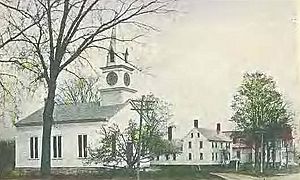
Four areas along Route 4 are considered historic parts of Northwood. These are East Northwood, Northwood Ridge, Northwood Center, and Northwood Narrows. The town is also home to Coe-Brown Northwood Academy, a school founded in 1867.
Geography of Northwood
Northwood covers a total area of about 78.3 square kilometers (about 30.2 square miles). Most of this is land, but about 5.4 square kilometers (2.1 square miles) is water. This means about 7% of the town is covered by water.
Northwood is famous for its many lakes and ponds. Some people live by the lakes all year, while others have seasonal homes. Important lakes include Bow Lake, which flows east into the Piscataqua River system. Other lakes like Northwood Lake, Pleasant Lake, Jenness Pond, Harvey Lake, and Long Pond flow west into the Suncook River. The Suncook River then joins the Merrimack River.
Meadow Lake is in the center of Northwood. It is where the Lamprey River begins. The Lamprey River flows south and is also part of the Piscataqua River system. The eastern part of town has the beginnings of the Bean River and North River, which are also part of the Lamprey River system.
The highest point in Northwood is Saddleback Mountain. It is about 170 meters (558 feet) above sea level. This mountain is near the town's southern border.
Neighboring Towns
Northwood shares its borders with several other towns:
- Strafford (to the north)
- Barrington (to the east)
- Nottingham (to the southeast)
- Deerfield (to the south)
- Epsom (to the west)
- Pittsfield (to the northwest)
Northwood's Ecosystem
Northwood has a rich and varied ecosystem. This means it has many different kinds of plants (flora) and animals (fauna). The weather in Northwood is a temperate, humid continental climate. This means it has warm summers and cold, snowy winters.
Here are some of the plants and animals you might find in Northwood:
Plants (Flora)
Animals (Fauna)
- Fisher
- American black bear
- Raccoon
- Red fox
- White-tailed deer
- Common loon
- Bald eagle
- Coyote
- Barred owl
- Great horned owl
- Moose
- Osprey
- Eastern wild turkey
- Great blue heron
- Eastern gray squirrel
- Eastern chipmunk
- North American porcupine
- Striped skunk
- Opossum
- Groundhog
- Largemouth bass
- Smallmouth bass
- Pickerel
- Yellow perch
- North American beaver
- Common snapping turtle
- Painted turtle
- Common garter snake
- Eastern American toad
- Red-spotted newt
Northwood's Population
Northwood has grown steadily over the years. In 1790, about 744 people lived there. By 2020, the population had grown to 4,641 people.
In 2000, there were 3,640 people living in Northwood. Most of the people were White (about 97.5%). A small percentage were African American, Native American, or Asian. About 0.55% of the population was Hispanic or Latino.
Many households in Northwood had children under 18 living with them (about 36.7%). Most households were married couples living together (62%). The average household had about 2.7 people.
The median age in Northwood in 2000 was 37 years old. This means half the people were younger than 37, and half were older. About 27% of the population was under 18 years old.
The median income for a household in Northwood was about $50,675 per year. This means half the households earned more than this, and half earned less. Only a small number of families and people lived below the poverty line.
Transportation in Northwood
Several important roads pass through Northwood. These include five New Hampshire state routes and two U.S. routes.
- NH 9, U.S. Route 4, and U.S. Route 202 all run together through the town. US 4 continues east, while US 202 and NH 9 go north.
- NH 43 goes through the eastern part of town.
- NH 107 enters from the west and also runs with NH 9, US 4, and US 202 for a bit before turning northwest.
- NH 202A connects Strafford to Northwood.
- NH 152 runs for a very short distance in the eastern edge of town.
Famous People from Northwood
- Albert O. Brown (1852–1937) was born in Northwood. He later became the 58th governor of New Hampshire.
- Ella Knowles (1860–1911) was also born in Northwood. She became a lawyer and politician.
Camps in Northwood
Northwood is home to two well-known camps:
- Camp Yavneh is a Jewish summer camp that started in 1944. It is located on Lucas Pond.
- Wah-Tut-Ca Scout Reservation is a Boy Scout camp. It is run by the Spirit of Adventure Council.
Images for kids
See also
 In Spanish: Northwood (Nuevo Hampshire) para niños
 | Toni Morrison |
 | Barack Obama |
 | Martin Luther King Jr. |
 | Ralph Bunche |


