Piscataqua River facts for kids
Quick facts for kids Piscataqua River |
|
|---|---|

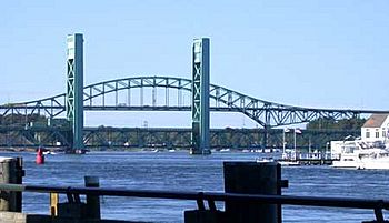
Piscataqua River from Portsmouth, New Hampshire, with the former Sarah Mildred Long Bridge and the Piscataqua River Bridge (background)
|
|
| Country | United States |
| State | New Hampshire, Maine |
| Physical characteristics | |
| Main source | Cochecho and Salmon Falls rivers New Hampshire/Maine border, United States 0 ft (0 m) 43°10′34″N 70°49′29″W / 43.17611°N 70.82472°W |
| River mouth | Atlantic Ocean Portsmouth Harbor, New Hampshire/Maine border, United States 0 ft (0 m) 43°3′22″N 70°42′11″W / 43.05611°N 70.70306°W |
| Length | 12 mi (19 km) |
| Basin features | |
| Tributaries |
|
The Piscataqua River is a 12-mile-long (19 km) tidal river. It forms the border between the U.S. states of New Hampshire and Maine. This river starts where the Salmon Falls River and Cocheco River meet.
The area that drains into the Piscataqua River is about 1,495 square miles (3,870 km2). This includes smaller rivers like the Great Works River. It also includes five rivers that flow into Great Bay: the Bellamy, Oyster, Lamprey, Squamscott, and Winnicut.
The river flows southeast. New Hampshire is to its south and west, and Maine is to its north and east. It eventually flows into the Gulf of Maine, which is part of the Atlantic Ocean. The last 6 miles (10 km) of the river before it reaches the sea is called Portsmouth Harbor. The water here moves quickly, with tidal currents around 4 knots (7.4 km/h; 4.6 mph). Many towns and cities have grown around this harbor, including Portsmouth, New Hampshire, New Castle, Newington, Kittery, and Eliot.
Contents
River History
Early Explorers and Names
The name Piscataqua comes from the Abenaki people, who lived in this area first. It is thought to combine peske (meaning "branch") with tegwe (meaning "a river with a strong current," possibly tidal).
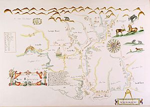
The first European known to explore the river was Martin Pring in 1603. Later, in 1614, Captain John Smith included a spelling similar to "Piscataqua" on his map of the region. The modern spelling "Piscataqua" was first written down in 1623. That same year, the first sawmill in the American colonies was built on this river.
River Life and Early Industries
Long ago, the Piscataqua River was full of many kinds of marine life. This included salmon, sturgeon, oysters, clams, scallops, lobsters, mussels, eels, and seals. You can still see evidence of this in the names of its smaller rivers and places. For example, there's the Salmon Falls River, Sturgeon Creek, and Seal Rock in Eliot, Maine. There's also the Oyster River in Durham, New Hampshire, and the Lamprey River in Newmarket, New Hampshire.
Today, most of these animals are still found in the river, except for salmon and sturgeon. Fishing for striped bass and bluefish is a popular sport here.
In the mid-1630s, some of the first settlers built a sawmill in what is now Berwick, Maine. This mill was on a smaller river that flows into the Piscataqua. It was likely the first water-powered mill in America. It became known as the "Great Works," which is how today's Great Works River got its name.
World War II and the Shipyard

After the Allies won in Europe during World War II, four German U-boats (submarines) that had surrendered traveled up the Piscataqua River. Their captains and crews were held as captured sailors at Portsmouth Naval Prison.
The first U-boat, U-805, arrived on May 15, 1945. It was towed up the river to meet U.S. officials. U-873 and U-1228 arrived the next day.
The U-boat U-234 was a very important capture. It arrived on May 19, after being seized off Nova Scotia by a U.S. Navy ship. This submarine had left Germany carrying a special cargo for Japan. It had parts for a Messerschmitt Me 262 jet plane, which was a very advanced fighter plane. It also carried two top Japanese scientists and two high-ranking Nazi officers.
Years later, the U.S. government revealed that U-234 also carried a secret load of uranium oxide. This material was made by the German atomic weapons program. It was meant for Japan's own efforts to build an atomic weapon. Instead, this valuable material was used by the U.S. in its top-secret Manhattan Project. It became part of the atomic bomb that the U.S. Army Air Corps dropped over Hiroshima to help end the war in the Pacific.
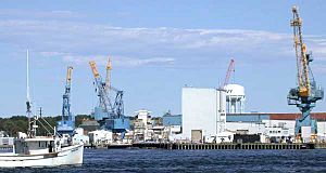
The Portsmouth Naval Shipyard is located on Seavey's Island in Kittery, Maine. It is near where the Piscataqua River meets the ocean. For a long time, some people thought the shipyard was in Portsmouth, New Hampshire. New Hampshire even claimed it into the 2000s. However, a disagreement over the border was settled by the U.S. Supreme Court in 2001. The court decided that the border between the states runs down the middle of the river's main channel. This means that Seavey's Island, and the shipyard, are officially in Maine.
River Estuary

The Piscataqua River and the rivers that flow into it, like Great Bay, form a large estuary. An estuary is a place where fresh water from rivers mixes with salt water from the ocean.
The Salmon Falls and Cocheco rivers join together to create the Piscataqua River. This happens near Dover, New Hampshire, and Eliot, Maine. Five other rivers with tidal sections flow into Great Bay. These are the Bellamy, Oyster, Lamprey, Squamscott, and Winnicut. The Great Works River also flows into the tidal part of the Salmon Falls River.
 | Audre Lorde |
 | John Berry Meachum |
 | Ferdinand Lee Barnett |


