
Berwick, Maine facts for kids
Quick facts for kids
Berwick
|
|
|---|---|

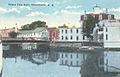
Sullivan Square in 1907
|
|
| Nickname(s):
The Berwicks
|
|
| Motto(s):
Where Tradition Meets Tomorrow
|
|

Berwick
Location in Maine
|
|
| Country | United States |
| State | Maine |
| County | York |
| Incorporated | 1713 |
| Government | |
| • Type | Town Manager Plan |
| Area | |
| • Total | 37.86 sq mi (98.06 km2) |
| • Land | 37.52 sq mi (97.18 km2) |
| • Water | 0.34 sq mi (0.88 km2) |
| Elevation | 338 ft (103 m) |
| Population
(2020)
|
|
| • Total | 7,950 |
| • Density | 212/sq mi (81.8/km2) |
| Time zone | UTC−5 (Eastern (EST)) |
| • Summer (DST) | UTC−4 (EDT) |
| ZIP Code |
03901
|
| Area code(s) | 207 |
| FIPS Code | 23-23031 |
| Website | www.berwickmaine.org |
Berwick is a town in Maine, located in York County, right next to the Salmon Falls River. It's in the southern part of the state.
Long ago, the areas that are now South Berwick and North Berwick were part of Berwick. South Berwick became its own town in 1814, and North Berwick followed in 1831.
In 2020, about 7,950 people lived in Berwick. It's part of a larger group of towns and cities around Portland, South Portland, and Biddeford.
Contents
Berwick's Story: A Look at Its History
The land where Berwick is today, along with South Berwick, North Berwick, and the Salmon Falls River, was first known as Newichawannock. This name came from the Abenaki people, who were the original inhabitants. It meant "river of many falls" or "land of great falls."
Early Settlements and Mills
Around 1631, a man named Ambrose Gibbens settled here. At first, this area was part of Kittery and was called Kittery Commons. Gibbens set up a trading post.
The thick forests in Southern Maine had huge pine trees perfect for building ships. The very first sawmill in English America was built here, near what is now South Berwick. It was known as Gibbens' Mill. Over time, many more sawmills were built, and logging became a very important industry. The first lumber shipped from the American colonies, like clapboards and barrel parts, left from South Berwick in 1634.
Scottish Prisoners and New Names
Later, Kittery North Parish was renamed Unity. This name came from a ship that brought Scottish prisoners of war to the colonies in 1650. These Scots were captured after the Battle of Dunbar in England. They were forced to march to Durham Cathedral and then tried for supporting King Charles II.
Many of these Scottish prisoners were sold as indentured servants. This meant they had to work for someone for a certain time to pay off their travel costs. Many worked at the Great Works mills near Berwick. An area near the border of Eliot and York is still called Scotland Bridge because many of them settled there.
Conflicts and Rebuilding
In 1675, there was a raid by Native Americans during a time known as King Philip's War. More attacks happened during King William's War in 1690–1691. During these raids, the village was burned and abandoned. About 30 settlers were killed, and over 50 were captured.
The town was settled again in 1703 and briefly called Newichawannock. Then, it was renamed Berwick, after a town in England called Berwick-upon-Tweed. The nearby town of Kittery wanted Berwick to be split into smaller towns before it officially became a town. However, on June 9, 1713, Berwick was officially made a town by the Massachusetts government. It was the ninth town in what is now Maine.
The first schoolhouse in Maine was built in Berwick in 1719. The town also faced more raids during Father Rale's War.
Town Divisions and Modern Industry
In 1749, the people of Berwick decided to divide the town into two parts: Blackberry Hill and Old Fields. These areas grew into distinct communities. In 1814, South Berwick became its own town, and North Berwick followed in 1831.
When the railroad arrived in the mid-1800s, Berwick didn't rely as much on its rivers for transport, but it still produced a lot of lumber. Berwick also had a close economic connection with Somersworth, New Hampshire, a mill town across the river.
Over time, other industries came to Berwick. Nute's Shoe Factory opened in the late 1800s, and Prime Tanning, a leather producer, started in the early 1900s. Prime Tanning grew to be a big international company. It closed its Berwick headquarters in 2008. In 2021, the town announced plans for a new development called The Edge at Berwick on the old Prime Tanning property.
-
Berwick as seen from Somersworth, NH c. 1912
-
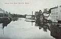
Looking up the Salmon Falls River in 1915
-
Rochester Street from the river in 1921
-

Old Sullivan High School about 1920


Berwick's Location and Climate
Where is Berwick?
According to the United States Census Bureau, Berwick covers about 37.86 square miles (98.06 square kilometers). Most of this is land, with a small amount of water. The town has two main rivers: the Little River and the Salmon Falls River.
The highest point in Berwick is Diamond Hill, which is about 490 feet (149.4 meters) above sea level. The lowest point is about 70 feet (21.3 meters) above sea level, along the Salmon River at the southern border with South Berwick.
You can reach Berwick using state routes 9 and 236.
What's the Weather Like?
Berwick has a humid continental climate. This means it has big differences in temperature throughout the year. Summers are warm to hot and often humid. Winters are cold, and sometimes very cold.
People of Berwick: Population Facts
| Historical population | |||
|---|---|---|---|
| Census | Pop. | %± | |
| 1790 | 3,894 | — | |
| 1800 | 3,891 | −0.1% | |
| 1810 | 4,455 | 14.5% | |
| 1820 | 2,736 | −38.6% | |
| 1830 | 3,168 | 15.8% | |
| 1840 | 1,698 | −46.4% | |
| 1850 | 2,121 | 24.9% | |
| 1860 | 2,155 | 1.6% | |
| 1870 | 2,291 | 6.3% | |
| 1880 | 2,774 | 21.1% | |
| 1890 | 2,294 | −17.3% | |
| 1900 | 2,280 | −0.6% | |
| 1910 | 2,098 | −8.0% | |
| 1920 | 2,057 | −2.0% | |
| 1930 | 1,961 | −4.7% | |
| 1940 | 1,971 | 0.5% | |
| 1950 | 2,166 | 9.9% | |
| 1960 | 2,738 | 26.4% | |
| 1970 | 3,136 | 14.5% | |
| 1980 | 4,149 | 32.3% | |
| 1990 | 5,995 | 44.5% | |
| 2000 | 6,353 | 6.0% | |
| 2010 | 7,246 | 14.1% | |
| 2020 | 7,950 | 9.7% | |
Berwick's Population in 2010
In 2010, there were 7,246 people living in Berwick. There were 2,749 households, and 2,029 of these were families. The town had about 193 people per square mile.
Most of the people in Berwick were White (96.2%). About 1.3% were Asian, and 0.5% were African American. A small number of people (1.3%) identified as Hispanic or Latino.
About 36.9% of households had children under 18 living with them. Most households (58.1%) were married couples. The average age in Berwick was 39.1 years old. About 25.2% of residents were under 18.
Famous People from Berwick
Many interesting people have connections to Berwick:
- Daniel B. Allyn – A high-ranking officer in the United States Army.
- John Jay Butler – A minister and professor.
- Hannah Tobey Farmer – A kind person who helped others, a writer, and worked for social change.
- Benjamin Franklin Hayes – A lawmaker and judge.
- Frederick Hayes – A soldier in the Civil War who received a medal for his bravery.
- John Alfred Hayes – A doctor for the Union Army.
- Thomas Lavigne – A state lawmaker.
- Jonathan Lethem – A well-known writer.
- Alphonso M. Lunt – An army sergeant.
- James Sullivan – The seventh governor of Massachusetts.
- Sarah Wilson – An English woman who pretended to be a princess and died in Berwick in 1780.
Schools in Berwick
Berwick is part of the MSAD60/RSU 60 school district.
There are three schools located right in Berwick:
- Vivian E. Hussey School (for students in Kindergarten to 3rd grade)
- Eric L. Knowlton School (for students in 4th to 5th grade)
- Noble Middle School (for students in 6th to 7th grade)
Students in grades 8 through 12 from Berwick go to Noble High School, which is in the nearby town of North Berwick.
Making Downtown Berwick Better
The Town of Berwick has received special grants to help improve its downtown area. In 2019, a company bought a property and has been working to develop it into a new area called The Edge at Berwick Maine. This project aims to bring new life and activities to the downtown.
See also
 In Spanish: Berwick (Maine) para niños
