
Eliot, Maine facts for kids
Quick facts for kids
Eliot
|
|
|---|---|

Welcome to Historic Eliot sign on ME Rt. 103 in South Eliot
|
|

Eliot
Location in Maine
|
|
| Country | United States |
| State | Maine |
| County | York |
| Incorporated | 1810 |
| Government | |
| • Type | Town Meeting |
| Area | |
| • Total | 21.32 sq mi (55.22 km2) |
| • Land | 19.78 sq mi (51.23 km2) |
| • Water | 1.54 sq mi (3.99 km2) |
| Elevation | 20 ft (6 m) |
| Population
(2020)
|
|
| • Total | 6,717 |
| • Density | 340/sq mi (131.1/km2) |
| Time zone | UTC-5 (Eastern (EST)) |
| • Summer (DST) | UTC-4 (EDT) |
| ZIP code |
03903
|
| Area code(s) | 207 |
| FIPS code | 23-22955 |
| GNIS feature ID | 0582464 |
Eliot is a town in York County, Maine, United States. It was first settled in 1623. Eliot used to be part of Kittery, which is to its east.
Eliot is one of the southernmost towns in Maine. It sits along the Piscataqua River. Across the river are Portsmouth and Newington, New Hampshire. In 2020, about 6,717 people lived in Eliot. It is part of the larger metropolitan area in Maine.
Eliot is home to interesting places like Ambush Rock, Green Acre, and the Raitt Homestead Farm Museum.
Contents
History of Eliot
How Eliot Was Founded
The area we know as Eliot today was once called the Middle Parish of Kittery, Maine. Kittery became an official town in 1647. It is known as "the oldest incorporated town in Maine."
However, people settled along the Piscataqua River in what is now Eliot much earlier. This was because the area was good for harbors, timber, and building ships. This is why Eliot claims it was "settled" in 1623, almost 25 years before Kittery became official.
In 1659, a local court decided Kittery should have two meeting houses. But the townspeople disagreed. In 1660, they decided to divide the town into three parts. Each part would pay for its own minister.
The Upper Parish later became the town of Berwick in 1713. The Middle Parish, which is now Eliot, was left without a meeting house. Its residents had to go to church in Dover, New Hampshire or Portsmouth.
Before Eliot became its own town in 1810, there were disagreements among the parishes. In 1791, the Middle Parish's minister died. Many people did not like the new minister chosen. They chose a different one in 1792.
Some people who supported the first minister were upset. They asked to join the Upper Parish in 1796, and they were allowed to. The Middle Parish felt that the other two parishes were working against them.
The town was likely named after Reverend John Eliot from Boston. He was a friend of General Andrew P. Fernald. General Fernald was important in helping Eliot become a separate town.
Scotland Bridge History
A part of northern Eliot, near York, is known as Scotland Bridge. This name came from Scottish prisoners of war. These prisoners were captured during the English Civil War at the Battle of Dunbar in 1650.
They were forced to march to Durham, England. There, they were tried for treason because they supported King Charles II. Many of these Scottish prisoners were then sent to America and resettled in this area. The name "Scotland Bridge" is still used today.
Eliot's Geography
Eliot covers about 21.32 square miles (55.22 square kilometers) in total. About 19.78 square miles (51.23 square kilometers) is land. The rest, about 1.54 square miles (3.99 square kilometers), is water.
Sturgeon Creek and the Piscataqua River flow through Eliot. Several state roads serve the town. These include Route 91, Route 101, Route 103, and Route 236. Eliot is located northwest of Interstate 95. It is also close to the New Hampshire border.
Eliot's Population
| Historical population | |||
|---|---|---|---|
| Census | Pop. | %± | |
| 1810 | 1,650 | — | |
| 1820 | 1,679 | 1.8% | |
| 1830 | 1,845 | 9.9% | |
| 1840 | 1,889 | 2.4% | |
| 1850 | 1,803 | −4.6% | |
| 1860 | 1,767 | −2.0% | |
| 1870 | 1,769 | 0.1% | |
| 1880 | 1,640 | −7.3% | |
| 1890 | 1,463 | −10.8% | |
| 1900 | 1,458 | −0.3% | |
| 1910 | 1,530 | 4.9% | |
| 1920 | 1,530 | 0.0% | |
| 1930 | 1,462 | −4.4% | |
| 1940 | 1,932 | 32.1% | |
| 1950 | 2,509 | 29.9% | |
| 1960 | 3,133 | 24.9% | |
| 1970 | 3,497 | 11.6% | |
| 1980 | 4,948 | 41.5% | |
| 1990 | 5,329 | 7.7% | |
| 2000 | 5,954 | 11.7% | |
| 2010 | 6,204 | 4.2% | |
| 2020 | 6,717 | 8.3% | |
| U.S. Decennial Census | |||
In 2022, the average household income in Eliot was about $93,231. The average family income was about $106,210. About 6.47% of the total population lived below the poverty line. This included 7.1% of those under 18 years old.
In 2010, there were 6,204 people living in Eliot. The average age in town was 45.4 years. About 22.1% of residents were under 18 years old. About 14.6% were 65 years or older. The population was almost evenly split between males (48.8%) and females (51.2%).
Places to Visit in Eliot
- Green Acre
- Raitt Homestead Farm Museum
- Ambush Rock
- Frost Garrison and House, Frost’s Hill
- Paul Family Farm, 106 Depot Road
- Fogg House
- Punkintown
- Sandy Hill Farm
Schools in Eliot (SAD35)
Eliot is part of School Administrative District 35 (SAD35). This district also includes South Berwick and Rollinsford.
- Eliot Elementary School
- Central School
- Great Works School
- Marshwood Middle School
- Marshwood High School
- Seacoast Waldorf School (private)
Famous People From Eliot
- Shem Drowne, a coppersmith and America's first known weathervane maker.
- Hannah Tobey Farmer, a generous person, writer, and social reformer. She was the wife of Moses G. Farmer.
- Moses Gerrish Farmer, an inventor.
- Sarah Jane Farmer, who started the Greenacre Conferences. She was the daughter of Moses G. Farmer.
- Charles Frost, a leader in the Colonial military.
- John Fremont Hill, a state congressman and US senator. He was also the 45th governor of Maine from 1901 to 1905.
Gallery
-
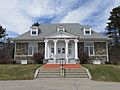
William Fogg Library
-
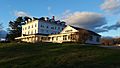
Green Acre
-
Sanctuary Arts studio
-

Frost House
-

Eliot Elementary School
-

Eliot Town Hall
-

Paul Family Farm
-

Sunset over the Piscataqua River on the Long Reach, Eliot on right, September 2014


.jpg)
See also
 In Spanish: Eliot (Maine) para niños
