
Boston facts for kids
Quick facts for kids
Boston
|
|||||
|---|---|---|---|---|---|
|
|
|||||
|
|||||
| Nickname(s):
Bean Town, Title Town, others
|
|||||
| Motto(s):
Sicut patribus sit Deus nobis (Latin)
'As God was with our fathers, so may He be with us' |
|||||

Boston
Location in Greater Boston area

Boston
Location in Massachusetts

Boston
Location in the United States
.svg)
Boston
Location in Earth
|
|||||
| Country | United States | ||||
| Region | New England | ||||
| State | Massachusetts | ||||
| County | Suffolk
|
||||
| Historic countries | Kingdom of England Commonwealth of England Kingdom of Great Britain |
||||
| Historic colonies | Massachusetts Bay Colony, Dominion of New England, Province of Massachusetts Bay | ||||
| Settled | 1625 | ||||
| Incorporated (town) |
September 7, 1630 (date of naming, Old Style)
September 17, 1630 (date of naming, New Style) |
||||
| Incorporated (city) | March 19, 1822 | ||||
| Named for | Boston, Lincolnshire | ||||
| Government | |||||
| • Type | Strong mayor / Council | ||||
| Area | |||||
| • State capital | 89.61 sq mi (232.10 km2) | ||||
| • Land | 48.34 sq mi (125.20 km2) | ||||
| • Water | 41.27 sq mi (106.90 km2) | ||||
| • Urban | 1,655.9 sq mi (4,288.7 km2) | ||||
| • Metro | 4,500 sq mi (11,700 km2) | ||||
| • CSA | 10,600 sq mi (27,600 km2) | ||||
| Elevation | 46 ft (14 m) | ||||
| Population
(2020)
|
|||||
| • State capital | 675,647 | ||||
| • Estimate
(2023)
|
653,833 | ||||
| • Rank | 66th in North America 25th in the United States 1st in Massachusetts |
||||
| • Density | 13,976.98/sq mi (5,396.51/km2) | ||||
| • Urban | 4,382,009 (US: 10th) | ||||
| • Urban density | 2,646.3/sq mi (1,021.8/km2) | ||||
| • Metro | 4,941,632 (US: 10th) | ||||
| Demonym(s) | Bostonian | ||||
| GDP | |||||
| • Metro | $610.486 billion (2023) | ||||
| Time zone | UTC−5 (EST) | ||||
| • Summer (DST) | UTC−4 (EDT) | ||||
| ZIP Codes |
53 ZIP Codes
02108–02137, 02163, 02196, 02199, 02201, 02203–02206, 02210–02212, 02215, 02217, 02222, 02126, 02228, 02241, 02266, 02283–02284, 02293, 02295, 02297–02298, 02467 (also includes parts of Newton and Brookline)
|
||||
| Area codes | 617 and 857 | ||||
| FIPS code | 25-07000 | ||||
| GNIS feature ID | 617565 | ||||
.jpg)

.jpg)
.jpg)


Boston is the capital and largest city in the state of Massachusetts in the United States. It is a major cultural and financial hub for the New England area. The city covers about 48.4 square miles and had a population of 675,647 people in 2020. This makes it the third-largest city in the Northeastern U.S. after New York City and Philadelphia. The larger Greater Boston area has about 4.9 million people, making it the biggest in New England.
Boston was started in 1630 by Puritan settlers. They named it after their hometown, Boston, Lincolnshire, in England. Boston was very important during the American Revolution. Key events like the Boston Massacre (1770) and the Boston Tea Party (1773) happened here. After the U.S. became independent, Boston grew as a port, a place for manufacturing, and a center for learning and culture.
Boston is known for many "firsts" in the U.S. It has the first public park (Boston Common, 1634), the first public school (Boston Latin School, 1635), and the first subway system (Tremont Street subway, 1897). Today, Boston is a world leader in higher education and research. It's also the biggest center for biotechnology globally. The city is a leader in science, law, medicine, engineering, and business. Boston is also known for its many startup companies and its focus on innovation and artificial intelligence.
Contents
- What's in a Name?
- Boston's Story: A Look Back
- Boston's Location and Landscape
- Who Lives in Boston?
- Boston's Economy: A Hub of Activity
- Learning in Boston
- Arts and Culture in Boston
- Sports in Boston
- Parks and Fun in Boston
- Media in Boston
- Getting Around Boston
- Boston's Global Connections
- Images for kids
- See also
What's in a Name?
Isaac Johnson named the new settlement "Boston" in 1630. He named it after his hometown, Boston, Lincolnshire, in England. Johnson and other settlers had moved from there to New England. The English town's name came from its patron saint, St. Botolph. Before it was called Boston, the area was known as "Shawmut" by William Blaxton and "Tremontaine" by the Puritans.
Boston's Story: A Look Back
Early People in Boston
Before Europeans arrived, the Massachusett people lived in the Boston area. They had small communities that moved with the seasons. By 1630, when settlers led by John Winthrop came, many Native people had died from European diseases. This left the Shawmut Peninsula mostly empty. Digs have found one of the oldest fishweirs in New England on Boylston Street. Native people built it as early as 7,000 years ago.
European Settlers Arrive
The first European to live in the Boston area was William Blaxton. He was an Anglican priest. He invited Puritan colonists to cross from Charlestown to the peninsula in September 1630. This is how Boston was founded.
The Puritans greatly influenced Boston's early history. They focused on education. America's first public school, Boston Latin School, was started in Boston in 1635. Boston was the largest town in the Thirteen Colonies until Philadelphia grew bigger in the mid-1700s. Boston's location by the ocean made it a busy port. It was important for shipping and fishing.
Revolution and the Siege


Many important events of the American Revolution happened in or near Boston. People in the town were growing unhappy with Britain. When Britain passed the Stamp Act in 1765, a Boston crowd attacked the homes of officials. In 1768, the British sent soldiers to Boston to calm things down. But this made colonists even angrier. In 1770, during the Boston Massacre, British soldiers shot into a crowd. This event was widely shared and helped start the revolution.
In 1773, Britain passed the Tea Act. Many colonists saw this as a way to force them to pay taxes. This led to the Boston Tea Party. A group of angry Bostonians threw a whole shipment of tea into Boston Harbor. The British government was furious and passed the Coercive Acts. This made the colonists even angrier and led to the American Revolutionary War. The war began near Boston with the Battles of Lexington and Concord.
Boston itself was surrounded for almost a year during the siege of Boston. This started on April 19, 1775. The New England militia stopped the British Army from moving easily. On June 17, the British captured Charlestown during the Battle of Bunker Hill. The British won, but they lost many soldiers. This showed how skilled the militia was.
Later, George Washington took charge of the militia. Both sides had problems with supplies. The fighting was mostly small attacks. The narrow Boston Neck made it hard for Washington to invade Boston. A long standoff followed. A young officer, Rufus Putnam, came up with a plan. They built portable forts and moved cannons to Dorchester Heights at night. The British woke up to see many cannons aimed at them. They tried to fight back but couldn't reach the American cannons. The British then left Boston by ship. This day, March 17, is still celebrated as "Evacuation Day" in Boston.
After the Revolution: Growth and Change

After the Revolution, Boston became one of the busiest ports in the U.S. Its long history with the sea helped. But the Embargo Act of 1807 and the War of 1812 slowed down trade. After these wars, foreign trade returned. But Boston's business owners had found new ways to invest their money. Manufacturing became very important to the city's economy. By the mid-1800s, factories were more important than international trade.
Boston also grew culturally. It was known for its writers and support for the arts. Wealthy Boston families, called Boston Brahmins, were seen as important in society and culture. They were often linked to Harvard University and the Episcopal Church.
Boston was a port for the Atlantic slave trade in New England. But it was soon passed by other cities. Boston later became a center for the movement to end slavery. In 1822, Boston officially changed from a "Town of Boston" to the "City of Boston." At that time, the city had about 46,226 people and was only 4.8 square miles.
The 1800s: A Changing City

In the 1820s, Boston's population grew quickly. Many European immigrants arrived. Irish immigrants were the first large group, especially after the Great Famine. By 1850, about 35,000 Irish people lived in Boston. Later in the 1800s, more Irish, Germans, Lebanese, Syrians, French Canadians, and Russian and Polish Jews settled in the city.
By the end of the 1800s, Boston's neighborhoods had distinct immigrant groups. Italians lived in the North End. Irish lived in South Boston and Charlestown. Russian Jews lived in the West End. Irish and Italian immigrants brought Roman Catholicism with them. Today, Catholics are the largest religious group in Boston. Irish Americans have been very important in Boston politics since the early 1900s.
Between 1631 and 1890, Boston tripled its size by filling in marshes and mud flats. This land reclamation created parts of the South End, the West End, the Financial District, and Chinatown. After the Great Boston fire of 1872, workers used building rubble to fill land along the waterfront. The city also added nearby towns like South Boston (1804), East Boston (1836), and Roxbury (1868).
The 1900s: Challenges and Rebirth

Many important buildings were built in the early 1900s. These include Horticultural Hall and the Isabella Stewart Gardner Museum. Fenway Park, home of the Boston Red Sox, opened in 1912. Logan International Airport opened in 1923.
Boston faced tough times in the mid-1900s. Factories became old, and businesses moved away for cheaper labor. Boston started projects to improve the city. One project in 1958 aimed to improve the historic West End. But many buildings were torn down, and thousands of families had to move. This caused strong public opposition.
The city continued with big projects, like clearing Scollay Square to build Government Center. By the 1970s, Boston's economy started to get better. Many tall buildings were built in the Financial District and Back Bay. This growth continued into the 1980s. Hospitals like Massachusetts General Hospital became leaders in medicine. Universities like Boston University and Northeastern University attracted many students.
In the 1970s, Boston also had conflicts over desegregation busing. This led to unrest around public schools. Housing prices also went up sharply from the 1990s.
Boston Today: The 2000s

Today, Boston is a center for ideas, technology, and politics. Some local businesses have merged with larger companies. For example, FleetBoston Financial was bought by Bank of America. The The Boston Globe newspaper, once owned by The New York Times, was sold back to a Boston businessman in 2013. In 2016, General Electric moved its main office to Boston's Seaport District. The huge Big Dig project, which moved a highway underground, was finished in 2007.
On April 15, 2013, two bombs exploded near the finish line of the Boston Marathon. Three people died, and many were injured. The city and nearby towns went into lockdown as police searched for the bombers. The region showed its strength and unity with the slogan Boston Strong.
In 2016, Boston considered bidding for the 2024 Summer Olympics. But the public did not support it, so the bid was dropped. However, Boston is one of eleven U.S. cities that will host matches for the 2026 FIFA World Cup at Gillette Stadium.
Boston's Location and Landscape


Boston covers about 89.63 square miles. About 54% of this is land, and 46% is water. The city's height above sea level is about 19 feet at Logan International Airport. The highest point in Boston is Bellevue Hill, which is 330 feet above sea level. The lowest point is at sea level. Boston is next to Boston Harbor, which is part of Massachusetts Bay and the Atlantic Ocean.
Boston is surrounded by the Greater Boston area. It borders towns like Winthrop and cities like Cambridge. The Charles River separates some of Boston's neighborhoods from Cambridge and Watertown. The Neponset River forms a border with Quincy and Milton.
Boston's Neighborhoods

Boston is often called a "city of neighborhoods" because it has many different areas. The city government officially recognizes 23 neighborhoods:
- Allston
- Back Bay
- Bay Village
- Beacon Hill
- Brighton
- Charlestown
- Chinatown
- Dorchester
- Downtown or Financial District
- East Boston (Eastie by locals)
- Fenway or Fenway-Kenmore
- Hyde Park
- Jamaica Plain
- Mattapan
- Mission Hill
- North End
- Roslindale
- Roxbury
- Seaport District or Seaport
- South Boston (Southie by locals)
- the South End
- the West End
- West Roxbury
More than two-thirds of Boston's land today was created by filling in water over centuries. This was done using dirt from leveling Boston's original three hills, called the "Trimountain." Gravel was also brought by train from Needham to fill the Back Bay.
Downtown and its nearby areas have many older brick buildings mixed with modern tall buildings. Back Bay has famous landmarks like the Boston Public Library and Trinity Church. The South End Historic District is the largest Victorian-era neighborhood still standing in the U.S.
The Big Dig project (1991-2007) greatly changed downtown and South Boston. It moved the elevated highway underground and created new green spaces.
Boston's Climate


Boston has a climate with warm, humid summers and cold, stormy winters. Spring and fall are usually cool and mild. The Atlantic Ocean doesn't affect the weather as much as you might think because winds usually blow from land to sea. However, near the coast in winter, there can be more rain than snow.
July is the hottest month, with an average temperature of about 74°F. January is the coldest, averaging about 30°F. Temperatures over 90°F in summer and below freezing in winter happen, but usually not for very long. It can get below 0°F every few years. The coldest temperature ever recorded was -18°F in 1934, and the hottest was 104°F in 1911.
Boston gets about 43.6 inches of rain each year. It also gets about 49.2 inches of snow per winter. Most snow falls from mid-November to early April. Snow is rare in May and October. The amount of snow can change a lot from year to year. For example, one winter might have only 9 inches of snow, while another might have over 110 inches. Being on the coast means Boston often gets big snow or rain storms called nor'easters.
Fog is common, especially in spring and early summer. Because it's on the coast, Boston often has sea breezes. These can make coastal temperatures much cooler than inland areas, especially in late spring. Thunderstorms happen from May to September. Sometimes they can be strong with large hail or heavy rain.
| Climate data for Boston (Logan Airport), 1981−2010 normals, extremes 1872−present | |||||||||||||
|---|---|---|---|---|---|---|---|---|---|---|---|---|---|
| Month | Jan | Feb | Mar | Apr | May | Jun | Jul | Aug | Sep | Oct | Nov | Dec | Year |
| Record high °F (°C) | 72 (22) |
73 (23) |
89 (32) |
94 (34) |
97 (36) |
100 (38) |
104 (40) |
102 (39) |
102 (39) |
90 (32) |
83 (28) |
76 (24) |
104 (40) |
| Mean maximum °F (°C) | 56.4 (13.6) |
57.7 (14.3) |
67.6 (19.8) |
80.7 (27.1) |
87.3 (30.7) |
92.1 (33.4) |
94.9 (34.9) |
93.3 (34.1) |
87.9 (31.1) |
79.1 (26.2) |
70.5 (21.4) |
61.3 (16.3) |
96.2 (35.7) |
| Mean daily maximum °F (°C) | 35.8 (2.1) |
38.7 (3.7) |
45.4 (7.4) |
55.6 (13.1) |
66.0 (18.9) |
75.9 (24.4) |
81.4 (27.4) |
79.6 (26.4) |
72.4 (22.4) |
61.4 (16.3) |
51.5 (10.8) |
41.2 (5.1) |
58.8 (14.9) |
| Mean daily minimum °F (°C) | 22.2 (−5.4) |
24.7 (−4.1) |
31.1 (−0.5) |
40.6 (4.8) |
49.9 (9.9) |
59.5 (15.3) |
65.4 (18.6) |
64.6 (18.1) |
57.4 (14.1) |
46.5 (8.1) |
38.0 (3.3) |
28.2 (−2.1) |
44.1 (6.7) |
| Mean minimum °F (°C) | 4.1 (−15.5) |
8.5 (−13.1) |
14.7 (−9.6) |
30.7 (−0.7) |
40.8 (4.9) |
49.6 (9.8) |
57.3 (14.1) |
55.4 (13.0) |
45.8 (7.7) |
34.9 (1.6) |
24.2 (−4.3) |
11.1 (−11.6) |
2.3 (−16.5) |
| Record low °F (°C) | −13 (−25) |
−18 (−28) |
−8 (−22) |
11 (−12) |
31 (−1) |
41 (5) |
50 (10) |
46 (8) |
34 (1) |
25 (−4) |
−2 (−19) |
−17 (−27) |
−18 (−28) |
| Average precipitation inches (mm) | 3.36 (85) |
3.25 (83) |
4.32 (110) |
3.74 (95) |
3.49 (89) |
3.68 (93) |
3.43 (87) |
3.35 (85) |
3.44 (87) |
3.94 (100) |
3.99 (101) |
3.78 (96) |
43.77 (1,112) |
| Average snowfall inches (cm) | 12.9 (33) |
10.9 (28) |
7.8 (20) |
1.9 (4.8) |
0 (0) |
0 (0) |
0 (0) |
0 (0) |
0 (0) |
trace | 1.3 (3.3) |
9.0 (23) |
43.8 (111) |
| Average precipitation days (≥ 0.01 in) | 11.3 | 9.8 | 11.6 | 11.2 | 12.0 | 10.9 | 9.6 | 9.4 | 8.6 | 9.4 | 10.6 | 11.6 | 126.0 |
| Average snowy days (≥ 0.1 in) | 6.7 | 5.3 | 4.2 | 0.7 | 0 | 0 | 0 | 0 | 0 | 0.1 | 0.8 | 4.6 | 22.4 |
| Average relative humidity (%) | 62.3 | 62.0 | 63.1 | 63.0 | 66.7 | 68.5 | 68.4 | 70.8 | 71.8 | 68.5 | 67.5 | 65.4 | 66.5 |
| Mean monthly sunshine hours | 163.4 | 168.4 | 213.7 | 227.2 | 267.3 | 286.5 | 300.9 | 277.3 | 237.1 | 206.3 | 143.2 | 142.3 | 2,633.6 |
| Percent possible sunshine | 56 | 57 | 58 | 57 | 59 | 63 | 65 | 64 | 63 | 60 | 49 | 50 | 59 |
| Source: NOAA (relative humidity and sun 1961−1990) | |||||||||||||
Who Lives in Boston?
In 2020, Boston had about 691,531 residents. This was a 12% increase from 2010. Boston is one of the most crowded large cities in the U.S. During work hours, about 1.2 million people might be in Boston. This is because many people from the suburbs come to the city for work, school, or healthcare.
About 21.9% of Boston's population is 19 years old or younger. The median age is 30.8 years. The average household size is 2.26 people.
From the 1950s to the end of the 1900s, the number of non-Hispanic White people in Boston went down. In 2000, non-Hispanic Whites made up 49.5% of the population. This meant the city had a "majority minority" population for the first time. However, in the 2000s, more wealthy White people moved into areas that were not mostly White before. This is called gentrification.
Different Backgrounds in Boston
_as_they_march_in_the_108th_Annual_St._Patrick%27s_Day_Parade.jpg)

African-Americans make up 22% of Boston's population. People of Irish descent are the second-largest group, at 15.8%. Italians are 8.3% of the population. People from the West Indies and Caribbean make up over 15% of the population.
Greater Boston has many people from Latin American countries. This includes Dominicans, Puerto Ricans, Salvadorans, Guatemalans, Mexicans, and Colombians. East Boston has a very diverse Hispanic/Latino population. Neighborhoods like Jamaica Plain and Roslindale have a growing number of Dominican Americans.
Boston also has a large and historic Armenian community. Over 27,000 Chinese Americans lived in Boston in 2013.
Religion in Boston
.jpg)
A 2014 study found that 57% of Boston's population identified as Christians. This included 29% Roman Catholic and 25% Protestant. About 33% said they had no religious affiliation. The rest were followers of Judaism, Buddhism, Islam, Hinduism, and other faiths.
The Catholic Church has the most followers in the Greater Boston area. The Episcopal Church and the United Church of Christ also have many members. The Boston area has a large Jewish population. Many Jewish households live in Boston itself or nearby towns.
Boston's Economy: A Hub of Activity
| Bos. | Corporation | US | Revenue (in millions) |
|---|---|---|---|
| 1 | General Electric | 18 | $122,274 |
| 2 | Liberty Mutual | 68 | $42,687 |
| 3 | State Street | 259 | $11,774 |
| 4 | American Tower | 419 | $6,663.9 |
| Rank | Company/Organization |
|---|---|
| 1 | Brigham and Women's Hospital |
| 2 | Dana Farber Cancer Institute |
| 3 | Massachusetts General Hospital |
| 4 | Beth Israel Deaconess Medical Center |
| 5 | Boston Children's Hospital |
| 6 | Boston Medical Center |
| 7 | Boston University School of Medicine |
| 8 | Massachusetts Bay Transportation Authority |
| 9 | TIAA |
| 10 | Tufts Children's Hospital |
Boston is a global city and one of the top 30 most powerful economies in the world. The Greater Boston area has the sixth-largest economy in the U.S.
Boston's many colleges and universities have a big impact on the economy. Over 350,000 college students come to Boston, adding billions of dollars to the city's economy each year. These schools are major employers and attract businesses. Boston is a hub for biotechnology, ranked as the top life sciences center in the country. It also gets the most funding for scientific research from the National Institutes of Health in the U.S.
The city is known for being very innovative. This is thanks to its universities, access to venture capital (money for new businesses), and many high-tech companies. The Route 128 corridor and Greater Boston are still major centers for new technology.
Tourism is also a big part of Boston's economy. Millions of visitors spend billions of dollars in the city each year. Boston is also a state capital, so government jobs are important. It is a major seaport on the East Coast and the oldest continuously used industrial and fishing port in the Western Hemisphere.
Boston is a top financial center in the U.S. Fidelity Investments, based in Boston, helped make mutual funds popular. The city is also home to Santander Bank and many venture capital firms. State Street Corporation, a big company for managing money, is also based here. Boston is a center for printing and publishing companies. The city has two large convention centers. Several major sports and shoe companies, like Converse and New Balance, have their headquarters in Boston.
Learning in Boston
Schools for All Ages

The Boston Public Schools system has 57,000 students in 145 schools. This includes famous schools like Boston Latin Academy and Boston Latin School. Boston Latin School was founded in 1635 and is the oldest public high school in the U.S. Boston also has the second-oldest public high school and the oldest public elementary school in the country.
Students in Boston's public schools come from many backgrounds. About 40% are Hispanic or Latino, 35% Black or African American, 13% White, and 9% Asian. There are also private, religious, and charter schools. Some minority students attend suburban schools through a program called METCO. In 2019, Boston started a program called Boston Saves. It gives every child in kindergarten a savings account with $50 for college or career training.
Colleges and Universities


Many of the world's top universities are near Boston. Three major universities, Harvard, MIT, and Tufts, are just outside Boston in Cambridge and Somerville. This area is sometimes called the Brainpower Triangle. Harvard is the oldest university in the U.S. Its main campus is in Cambridge, but many of its buildings and activities are in Boston. For example, its business and medical schools are in Boston. MIT started in Boston and moved to Cambridge in 1916. Tufts University's main campus is north of the city, but its medical and dental schools are in Boston's Chinatown.
Greater Boston has over 50 colleges and universities. About 250,000 students are enrolled in Boston and Cambridge alone. Boston's largest private universities include Boston University, Northeastern University, and Suffolk University. Boston College is on the border of Boston and Newton. The only public university in Boston is the University of Massachusetts Boston. Boston's colleges and universities employ over 42,600 people.
Greater Boston has more top research universities than any other U.S. metropolitan area. Hospitals and universities in the area receive billions of dollars in research grants. This means there are many young researchers in Boston.
Smaller private colleges include Boston Architectural College and Emerson College. The region also has several music and art schools, like the New England Conservatory and Berklee College of Music. These schools make Boston an important city for jazz music. There are also many trade schools in the city.
Arts and Culture in Boston
.jpg)


Boston shares many cultural traditions with New England. This includes a special way of speaking English called the Boston accent. The local food often features seafood, salt, and dairy. Boston also has its own unique slang and a dry sense of humor.
In the early 1800s, Boston was called the "Athens of America" because of its strong literary culture. It was known as "the intellectual capital of the United States." In the 1800s, famous writers like Ralph Waldo Emerson and Henry David Thoreau wrote in Boston. The Old Corner Bookstore was a popular meeting place for these writers. In 1852, the Boston Public Library was founded as the first free library in the U.S. Boston's love for literature continues today with its many universities and the Boston Book Festival.
Music is very important in Boston. The Boston Symphony Orchestra is one of the "Big Five" best American orchestras. Symphony Hall is home to the Boston Symphony Orchestra and the Boston Youth Symphony Orchestra. The Boston Pops Orchestra also performs there. The Boston Ballet performs at the Boston Opera House. Other groups include the Boston Lyric Opera Company and the Handel and Haydn Society. Several theaters are in the Theater District near Boston Common.
Boston has several big annual events. First Night happens on New Year's Eve. The Boston Early Music Festival and the Boston Arts Festival are also popular. In June, there is an annual Boston gay pride parade. The city also hosts events for Fourth of July, including the Harborfest and a Boston Pops concert with fireworks.
Many historic sites from the American Revolution are part of the Boston National Historical Park. You can find many of these along the Freedom Trail, which is marked by a red line on the ground.
Boston has several art museums and galleries. These include the Museum of Fine Arts and the Isabella Stewart Gardner Museum. The Institute of Contemporary Art is in the Seaport District. Other popular places are the Boston Children's Museum, the Museum of Science, and the New England Aquarium.
Boston has always been an important religious center. The Roman Catholic Archdiocese of Boston has nearly 300 churches. The Cathedral of the Holy Cross is its main church. The oldest church in Boston is First Church in Boston, founded in 1630. Other historic churches include Old North Church (1723) and Trinity Church (1733).
Sports in Boston

Boston has teams in all four major North American men's professional sports leagues, plus Major League Soccer. As of 2024, Boston teams have won 40 championships. From 2001 to 2024, Boston's teams won thirteen championships! The Patriots won six Super Bowls, the Red Sox won four World Series, the Celtics won two NBA championships, and the Bruins won one Stanley Cup.
The Boston Red Sox are a founding member of Major League Baseball's American League. They play at Fenway Park, which opened in 1912. It is the oldest sports stadium still in use in the U.S. among the major leagues. Boston hosted the first game of the first modern World Series in 1903.

The TD Garden is home to the Boston Bruins of the National Hockey League and the Boston Celtics of the National Basketball Association. The Bruins were the first American team in the NHL. The Celtics have won eighteen championships, which is the most of any NBA team.
The New England Patriots of the National Football League were founded in 1960 as the Boston Patriots. They moved to Foxborough in 1971. They have won six Super Bowls. They share Gillette Stadium with the New England Revolution of Major League Soccer.

Many colleges and universities in the area have active sports programs. Four NCAA Division I teams play here: Boston College, Boston University, Harvard University, and Northeastern University. These four universities compete in the Beanpot, an annual college ice hockey tournament.
Boston also has Esports teams, like the Overwatch League's Boston Uprising and the Call of Duty League's Boston Breach.
One of the most famous sporting events in the city is the Boston Marathon. This 26.2-mile race is the world's oldest annual marathon. It is run on Patriots' Day in April. The Red Sox traditionally play a home game that starts early on the same day. This lets fans watch runners finish the marathon after the game. Another big event is the Head of the Charles Regatta, a rowing race held in October.
| Team | League | Sport | Venue | Capacity | Founded | Championships |
|---|---|---|---|---|---|---|
| Boston Red Sox | MLB | Baseball | Fenway Park | 37,755 | 1903 | 1903, 1912, 1915, 1916, 1918, 2004, 2007, 2013, 2018 |
| Boston Bruins | NHL | Ice hockey | TD Garden | 17,850 | 1924 | 1928–29, 1938–39, 1940–41, 1969–70, 1971–72, 2010–11 |
| Boston Celtics | NBA | Basketball | TD Garden | 19,156 | 1946 | 1956–57, 1958–59, 1959–60, 1960–61, 1961–62, 1962–63, 1963–64, 1964–65, 1965–66, 1967–68, 1968–69, 1973–74, 1975–76, 1980–81, 1983–84, 1985–86, 2007–08, 2023–24 |
| New England Patriots | NFL | American football | Gillette Stadium | 65,878 | 1960 | 2001, 2003, 2004, 2014, 2016, 2018 |
| New England Revolution | MLS | Soccer | Gillette Stadium | 20,000 | 1996 | None |
Parks and Fun in Boston

Boston Common is the oldest public park in the United States. It is near the Financial District and Beacon Hill. Along with the Boston Public Garden, it is part of the Emerald Necklace. This is a series of parks designed by Frederick Law Olmsted that runs through the city. The Emerald Necklace includes the Back Bay Fens, Arnold Arboretum, and Franklin Park. Franklin Park is the city's largest park and home to the Franklin Park Zoo.
Another major park is the Esplanade, which runs along the Charles River. The Hatch Shell, an outdoor concert venue, is next to the Esplanade. Many other parks and beaches are found throughout the city. These include areas near Castle Island and along the shorelines of Dorchester, South Boston, and East Boston.
Media in Boston
Newspapers
The Boston Globe is the oldest and largest daily newspaper in Boston. It is considered the city's main newspaper. Other publications include the Boston Herald and Boston magazine. The Christian Science Monitor, based in Boston, used to be a daily newspaper but is now mostly online. The Boston Globe also has a teen publication called Teens in Print, written by local teens.
Boston's growing Latino population has led to several Spanish-language newspapers. These include El Planeta and El Mundo. There are also LGBT (lesbian, gay, bisexual, and transgender) publications like The Rainbow Times, which serves all of New England.
Radio and Television
Boston is the largest broadcasting market in New England. It has many radio stations, including talk radio WRKO, sports station WEEI, and news radio WBZ (AM). WBZ is a very powerful station that can be heard far away at night. There are also many commercial FM stations and NPR stations like WBUR and WGBH. Many colleges and universities also have their own radio stations.
Boston's television market is the eighth largest in the U.S. The city has stations for every major American network, including CBS (WBZ-TV), ABC (WCVB-TV), NBC (WBTS-CD), and Fox (WFXT). Boston is also home to PBS station WGBH-TV, which produces many PBS programs. Spanish-language TV networks also have a presence in the region. Most of the area's TV stations have their transmitters in nearby Needham and Newton.
Getting Around Boston

Logan International Airport, in East Boston, is Boston's main airport. It is run by the Massachusetts Port Authority (Massport). Massport also operates several major facilities at the Port of Boston, including a cruise ship terminal.
Downtown Boston's streets grew over time, so they are not in a neat grid pattern. But newer areas like Back Bay and East Boston have planned grids. I-90 ends in Boston. I-93 is the main north-south highway through downtown. Other major highways include US 1 and US 3. Around the city is Massachusetts Route 128, a partial beltway.
Boston has one of the highest rates of public transit use in the country. Almost a third of Bostonians use public transit to get to work. The city has fewer cars per household than the national average. Boston's public transportation agency, the Massachusetts Bay Transportation Authority (MBTA), runs the oldest subway system in the Americas. It is the fourth-busiest subway system in the U.S. The MBTA also operates busy bus and commuter rail networks, as well as water shuttles.

Amtrak trains to Boston stop at four stations: South Station, North Station, Back Bay, and Route 128. South Station is a major hub for different types of transportation.
Boston is nicknamed "The Walking City" because many people walk to work. About 13% of the population walks to work, which is the highest percentage among major American cities. As of 2024, Boston is ranked as the third most walkable U.S. city.

Boston also has a high rate of bicycle commuting. The bikeshare program Bluebikes started in 2011. It has 480 stations and 4,500 bikes.
Boston's Global Connections
The City of Boston has eleven official sister cities:
 Kyoto, Japan (1959)
 Strasbourg, France (1960)
 Barcelona, Spain (1980)
 Hangzhou, China (1982)
 Padua, Italy (1983)
 City of Melbourne, Australia (1985)
 Beira, Mozambique (1990)
 Taipei, Taiwan (1996)
 Sekondi-Takoradi, Ghana (2001)
 Belfast, Northern Ireland (2014)
 Praia, Cape Verde (2015)
Boston also has formal partnerships with five other cities or regions:
- Guangzhou, China (2014)
- Lyon, France (2016)
 Copenhagen, Denmark (2017)
 Mexico City, Mexico (2017)
 North West of Ireland, Ireland (2017)
Images for kids
-
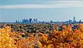
Boston's skyline with beautiful fall foliage.
-
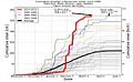
A graph showing winter snowfall in Boston from 1938 to 2015.
See also
 In Spanish: Boston para niños
