Fenway–Kenmore facts for kids
Quick facts for kids
Fenway–Kenmore
|
|
|---|---|

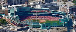
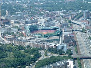
Fenway Park, home of the Boston Red Sox, is located in the Fenway–Kenmore neighborhood.
|
|
| Country | United States |
| State | Massachusetts |
| County | Suffolk |
| City | Boston |
| Area | |
| • Total | 1.24 sq mi (3.2 km2) |
| Population
(2010)
|
40,898 |
| • Density | 32,982.3/sq mi (12,734.5/km2) |
| Time zone | UTC-5 (Eastern) |
| ZIP code(s) |
02115, 02215
|
| Area code(s) | 617, 857 |
Fenway–Kenmore is a well-known neighborhood in Boston, Massachusetts. It's officially recognized as one area. However, people often refer to its different parts as "Fenway" or "Kenmore Square."
The name "Fenway" comes from a main road called The Fenway. This road was designed by a famous landscape architect named Frederick Law Olmsted. In 2010, about 40,898 people lived in Fenway–Kenmore. The neighborhood covers about 1.24 square miles.
Contents
Fenway–Kenmore: Where is This Cool Boston Neighborhood?
Fenway–Kenmore is located in a busy part of Boston. To the east, it borders the Back Bay neighborhood. The South End is also nearby, across Huntington Avenue. Here, you can find The First Church of Christ, Scientist headquarters, which many tourists visit.
The neighborhood is split into East Fenway and West Fenway by the Muddy River. This river flows through the Back Bay Fens park and into the Charles River. The Longwood Medical Area, a big center for hospitals and medical schools, is sometimes seen as part of Fenway.
Kenmore is mostly north and west of Fenway, separated by the Massachusetts Turnpike. This area includes part of the Boston University campus. Southwest of Boston University and west of the Longwood Medical Area is the town of Brookline.
Throughout Fenway–Kenmore, you'll see many old buildings. These include brownstone townhouses and brick apartment buildings. They were mostly built between 1880 and 1930. You can also find small, local shops. The main shopping areas are in Kenmore Square and along streets like Brookline Avenue and Boylston Street.
The famous baseball stadium, Fenway Park, home of the Boston Red Sox, is right next to Kenmore Square. Many students live here because parts of several universities are in the neighborhood. These include Boston University, Northeastern University, the Berklee College of Music, and the Boston Conservatory of Music.
A Look Back: History of Fenway–Kenmore
The Fenway–Kenmore area was created from land that used to be part of Brookline in the 1870s. More land was added in the 1890s when Frederick Law Olmsted designed parks here.
When the area was first planned, people thought rich families would live in the fancy buildings along The Fenway road. However, as land prices went up, many schools and universities moved in instead. By 1907, there were 22 educational groups, including nine colleges, in the Fenway area.
Rules were put in place for new buildings. The Park Board had to approve how buildings looked from the street. This was to make sure that "poor looking building[s]" didn't make the whole neighborhood seem less valuable. They wanted the Fenway area to look better than nearby streets.
In recent years, Fenway–Kenmore has seen a lot of new building projects. For example, the Landmark Center was updated. A new hotel, Hotel Commonwealth, was built in 2003. Also, a large apartment building called Trilogy was completed. Another tall apartment building, 1330 Boylston, finished in 2008. It has apartments, office space, and is home to Fenway Health.
More projects are planned for the future. These include new mixed-use buildings with shops, restaurants, and apartments. The Howard Johnson motel on Boylston Street is also being turned into a nicer hotel. There are also plans for a big complex called One Kenmore, with two tall towers.
Transportation has also been improved. The Fenway Green Line subway stop was updated in 2007. The nearby Yawkey commuter rail station was also renovated in 2014. Plus, the Museum of Fine Arts, Boston and the Isabella Stewart Gardner Museum have both expanded recently.
How Streets Got Their Names
Many streets in West Fenway are named after Scottish cities and towns. These names come from the works of the famous Scottish poet, Robert Burns. Examples include Peterborough, Kilmarnock, and Queensberry. This happened because the Burns Memorial Association of Boston influenced the city's street naming.
Originally, in 1894, the plan was to continue the alphabetical street naming system from the Back Bay. But this simpler Scottish theme was chosen instead.
The parkways around the Back Bay Fens, like Fenway and Park Drive, are named after parks in the Emerald Necklace system. Other streets in Fenway are named after important people or institutions in the neighborhood. For example, Evans Way is named after someone who donated to the Museum of Fine Arts. Symphony Road was named because of its closeness to the Boston Symphony Orchestra.
Who Lives Here? Demographics
| Historical population | |||
|---|---|---|---|
| Census | Pop. | %± | |
| 1980 | 30,842 | — | |
| 1990 | 32,880 | 6.6% | |
| 2000 | 36,191 | 10.1% | |
| 2010 | 40,989 | 13.3% | |
In 2000, about 36,191 people lived in Fenway–Kenmore. Most of the homes are apartments, with many buildings having 20 or more units. About 91% of the homes were rented, and 9% were owned by the people living there. The average household had about 1.69 people.
The neighborhood is very diverse. In 2000, about 71% of residents were White, 7% Black or African American, and 14% Asian. About 8% of the population was Hispanic or Latino. Also, 21.3% of the people living here were born outside the United States.
Many young people live in Fenway–Kenmore. About 63% of the population was between 18 and 24 years old. This is because of all the colleges and universities nearby. East Fenway has a very large student population. West Fenway, which used to have many students, is now attracting more young professionals and families. The Kenmore Square area is mostly for businesses, but Boston University owns many residential buildings there for student housing.
What's Here? Famous Places and Institutions
Fenway–Kenmore is home to many famous places and important institutions:
- Fenway Park, where the Boston Red Sox play baseball.
- The famous Boston Citgo sign in Kenmore Square.
- Kenmore Square itself, a busy hub.
- Many colleges and universities, including:
- The Art Institute of Boston
- Massachusetts College of Pharmacy and Health Sciences
- Northeastern University
- New England Conservatory
- Parts of Boston University
- Parts of Harvard Medical School, Harvard School of Dental Medicine, and Harvard T.H. Chan School of Public Health
- Berklee College of Music
- The Boston Conservatory
- Massachusetts College of Art
- Wentworth Institute of Technology
- Simmons College
- Wheelock College
- Emmanuel College
- New England School of Photography
- Important cultural spots:
- Holy Trinity Orthodox Cathedral
- The Isabella Stewart Gardner Museum
- The Museum of Fine Arts, Boston
Getting Around: Transportation
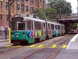
It's easy to get around Fenway–Kenmore using public transportation. The neighborhood is served by the MBTA Orange Line subway at the [[{{{station}}} (MBTA station)|{{{station}}}]] station. It also has several MBTA Green Line light rail stops:
- [[{{{station}}} (MBTA station)|{{{station}}}]] – for the B, C, and D branches
- [[{{{station}}} (MBTA station)|{{{station}}}]] – for the D branch
- [[{{{station}}} (MBTA station)|{{{station}}}]] – for the C branch
- [[{{{station}}} (MBTA station)|{{{station}}}]] – for the E branch
- [[{{{station}}} (MBTA station)|{{{station}}}]] – for the E branch
- [[{{{station}}} (MBTA station)|{{{station}}}]] – for the E branch
The Lansdowne station for the MBTA Commuter Rail is also nearby. It's close to Fenway Park and Kenmore Square. Many MBTA bus routes also connect Fenway–Kenmore to other parts of Boston and nearby towns.
For driving, major roads include Fenway and Park Drive, which go around the Fens. Boylston Street, Beacon Street (Route 2), and Commonwealth Avenue (U.S. Route 20) are important east-west routes. These three streets meet at Kenmore Square. Brookline Avenue starts in Kenmore Square and goes southwest. Huntington Avenue (Route 9) is on the southern edge, and Massachusetts Avenue is on the eastern edge.
Storrow Drive is the only highway that directly serves the neighborhood. It has exits that connect to Kenmore Square, Boylston Street, and Park Drive. Even though the Massachusetts Turnpike goes through the neighborhood, there are no direct exits to Fenway–Kenmore except for westbound traffic at Massachusetts Avenue.
 | Dorothy Vaughan |
 | Charles Henry Turner |
 | Hildrus Poindexter |
 | Henry Cecil McBay |


