
Kenmore Square facts for kids
Quick facts for kids
Kenmore Square
|
|
|---|---|

Kenmore Square in November 2011
|
|
| State | Massachusetts |
| City | Boston |
| Intersection | Beacon Street, Commonwealth Avenue |
| Historical features | Citgo sign |
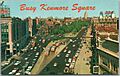
Kenmore Square is a busy public square in Boston, Massachusetts. It's a well-known spot in the Fenway–Kenmore neighborhood. This square is where three important streets meet: Beacon Street, Commonwealth Avenue, and Brookline Avenue. It's also the very end of U.S. Route 20, which is the longest highway in the United States! You can't miss the famous Citgo sign here, and Fenway Park, where the Boston Red Sox play baseball, is just a short walk away. Underneath the square is Kenmore station, a subway and bus stop that helps people get around.
Contents
The History of Kenmore Square
From Marshland to a Busy Hub
Long, long ago, the land where Kenmore Square now stands was mostly empty. It was a marshy area where the Charles River met the wide Back Bay. This land was part of the original Boston settlement. But in 1705, a small area called Muddy River became its own town, Brookline. The Muddy River itself formed the new border.
An old map from 1821 shows this area as "Sewell's Point." Important roads like Brighton Road (now part of Commonwealth Avenue) and Punch Bowl Road (now Brookline Avenue) met here. These roads connected Sewell's Point to the mainland.
Building Roads and Connections
In 1850, a part of Beacon Street was built. It crossed paths with other roads, including what is now Commonwealth Avenue and Brookline Avenue. Two railroad lines also met here. They crossed the Back Bay on a special bridge. These railroad lines are still used today, even as the city has grown all around them.
In 1874, the town of Brighton joined Boston. This changed the border between Boston and Brookline. It helped connect the new Back Bay area with Allston-Brighton. Even in 1880, the square, then called Governor Square, didn't have many buildings. By 1890, a big project to fill in the Back Bay marshland reached the square. This finally connected it fully to the eastern parts of Boston.
The Rise of Public Transport
Streetcar tracks were put on Beacon Street in 1888. These streetcars went right through Governor Square. They would later become part of the Green Line C branch of Boston's subway system. More tracks were added in 1896 on Commonwealth Avenue. These tracks would serve the Green Line A branch and Green Line B branch.
The subway system was extended to Kenmore Square in 1914. For a while, streetcars still crossed the busy square above ground. But in 1932, the underground Kenmore station opened. This made it much easier for people to travel.
A New Name and a Bus Terminal
On December 31, 1931, Governor Square got a new name: Kenmore Square. The name came from a nearby streetcar stop, which was named after the short Kenmore Street. In 1943, the park in the middle of the square was replaced by a bus terminal. This helped make travel even more convenient.
The Famous Hotel Kenmore
In 1915, the Kenmore Apartments were built near Kenmore Square. Later, these apartments became the Hotel Kenmore. It had 400 rooms! Bertram Druker, a well-known Boston builder, owned the hotel. It was famous as the "baseball hotel" because almost every out-of-town Major League Baseball team stayed there after World War II.
From the 1960s to 1979, a school called Grahm Junior College used the hotel for dorms, a cafeteria, a library, and classrooms. After the college closed and bigger hotels were built, the Hotel Kenmore became apartments again. Today, it is called Kenmore Abbey.
Images for kids
-
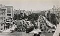
Streetcars crossing Governors Square in 1930
-
Kenmore Square in the 1930s, after the subway station opened
-
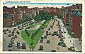
Kenmore Square in the 1950s, after the bus terminal was built
-

The modern bus terminal in 2016


