
Commonwealth Avenue (Boston) facts for kids

Commonwealth Avenue in 2006
|
|
| Length | 11.0 mi (17.7 km) |
|---|---|
| West end | |
| Major junctions |
|
| To | Arlington Street in Back Bay |
| North | Marlborough Street (Back Bay) |
| South | Newbury Street (Back Bay) |

Commonwealth Avenue, often called Comm Ave, is a very important street in Boston and Newton, Massachusetts. It starts at the western edge of the Boston Public Garden. From there, it stretches west through many neighborhoods. These include Back Bay, Kenmore Square, Boston University, Allston, Brighton, and Chestnut Hill.
The avenue then becomes part of Route 30 as it goes through Newton. It finally crosses the Charles River at the border of Weston.
Contents
Exploring Commonwealth Avenue's Design
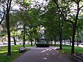
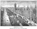
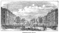
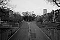
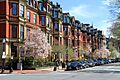
Commonwealth Avenue in the Back Bay area is a beautiful parkway. It's often compared to the grand boulevards you might see in Paris. A wide, grassy area runs down the middle of the street. This green space is called the Commonwealth Avenue Mall.
The Commonwealth Avenue Mall: A Green Oasis
The Mall is filled with statues and memorials. It's also the narrowest part of Boston's famous Emerald Necklace. This is a chain of parks and green spaces. The Mall connects the Public Garden to the Fens. It's a lovely place for a walk or to relax.
Public Transport and University Life
As Commonwealth Avenue reaches Kenmore Square, you'll see the MBTA Green Line B branch train tracks. The train runs above ground here. It takes over the center of the road as it passes through the Boston University campus. It continues through the neighborhoods of Allston and Brighton.
After leaving Boston and entering Chestnut Hill in Newton, the avenue goes past Boston College. This is also where the Green Line B Branch ends. The train tracks are replaced by grass in the middle of the road. The area starts to look more like a quiet suburb with homes.
Suburban Charm and Marathon Hills
In Newton, Comm Ave still has two roadways. They are separated by a grassy, tree-lined area. The south side has the main road. The north side has a special "carriage road." This is a one-way road for local traffic.
A section of Comm Ave from Brighton to Route 16 in Newton is part of the Boston Marathon route. This part is famous for its challenging "Newton hills." The carriage road continues into West Newton. The road then goes over the Massachusetts Turnpike in Auburndale. Commonwealth Avenue finally ends when it leaves Newton. It crosses the Charles River and connects with Route 128.
Boston University's Central Hub
A 1.5-mile (2.4 km) stretch of Commonwealth Avenue is home to much of Boston University's campus. This part runs between Kenmore Square and Packard's Corner. Boston University owns many buildings along this section. It's the main route for getting around the university's Charles River Campus. Many students and people walk, bike, or use other transport here. Walking from one end to the other takes about 25 to 35 minutes.
Commonwealth Avenue's Rich History
Commonwealth Avenue has a long and interesting history. Its design and development involved some famous landscape architects.
Who Designed Comm Ave?
The beautiful Commonwealth Avenue Mall was designed by Arthur Delevan Gilman. Later, Frederick Law Olmsted designed the Newton part of Commonwealth Avenue. He made sure it was part of the larger Emerald Necklace park system. The very first statue on the Commonwealth Avenue Mall was put up in 1865. It stands at Arlington Street.
Early Developments and Transport
The Newton end of the road was built in 1895. It included a streetcar line in the middle of the road. In 1923, a section of Commonwealth Avenue became the first street in Boston paved with concrete. Streetcar service was later shortened in 1930. Buses stopped running on Commonwealth Avenue in 1976.
An amusement park and ballroom called Norumbega Park was built in 1897. It was located at the end of the streetcar line on the Charles River. This park was created to encourage more people to ride the streetcars.
Recognized for its Beauty and Importance
The eastern half of the Newton section of the road is listed on the National Register of Historic Places. It's known as the Commonwealth Avenue Historic District. The Mall, with its landscapes, monuments, and fences, was named a Boston Landmark in 1978.
Modern Updates for Cyclists
In 2020, special protected bike lanes were added between the BU Bridge and Packards Corner. These new lanes made it much safer for cyclists. As a result, the number of people using bikeshare services in that area tripled!
Statues Along the Mall
The Commonwealth Avenue Mall is like an outdoor museum. As you walk from the Public Garden heading west, you can see many important statues:
- Alexander Hamilton: He helped write the The Federalist Papers. This was the first statue placed on the mall in 1865.
- Statue of John Glover: This statue honors John Glover, a soldier from the American Revolutionary War. It was sculpted in 1875.
- Bust of Patrick Collins: This shows Patrick Andrew Collins, who was a mayor of Boston. It was moved in 1966 due to construction.
- The Vendome Memorial: This memorial remembers nine firefighters who died in the 1972 Hotel Vendome fire. It was created in 1997.
- William Lloyd Garrison: He was an important abolitionist (someone who fought to end slavery) and journalist.
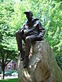
- Samuel Eliot Morison: A famous naval historian and writer. This statue was made in 1982.
- The Boston Women's Memorial: This memorial features statues of three important women: Abigail Adams, Lucy Stone, and Phillis Wheatley. It was unveiled in 2003.
- Domingo Sarmiento: He was a former president of Argentina. This statue was a gift from the Argentine government in 1913, but it arrived in Boston sixty years later in 1973.
- Leif Ericson: He was the first European to discover Newfoundland. This statue was created in 1887.
Images for kids
-

Hamilton Statue, 19th century
-
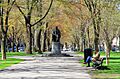
Statue of Samuel Eliot Morison on the mall, 2006
-
The Commonwealth Avenue Mall looking west towards the Alexander Hamilton statue, 2006
-
c. 1881
-
c. 1886
-
Vendome, 19th century
-
1901
-
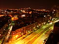
Overview of Commonwealth Ave., Brighton, 2007
-
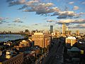
Overview, near Kenmore Square, 2007
-
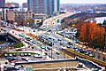
Comm. Ave, near Boston University, 2009
-
Near Massachusetts Avenue, 2010
-
Commonwealth Avenue Mall with statue of William Lloyd Garrison, 2013
-
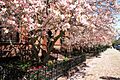
Magnolias, Commonwealth Avenue, 2013
-
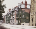
Brownstones


