Newton, Massachusetts facts for kids
Quick facts for kids
Newton, Massachusetts
|
|||
|---|---|---|---|
| City of Newton | |||
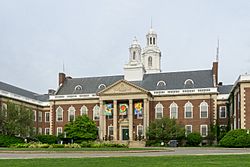
City Hall
|
|||
|
|||
| Nickname(s):
"The Garden City"
|
|||
| Motto(s):
"Liberty and Union"
|
|||
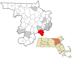
Location in Middlesex County, Massachusetts
|
|||
| Country | United States | ||
| State | Massachusetts | ||
| County | Middlesex | ||
| Settled | 1630 | ||
| Incorporated (Town) | 1681 | ||
| Incorporated (City) | 1874 | ||
| Government | |||
| • Type | Mayor–council | ||
| Area | |||
| • Total | 18.16 sq mi (47.03 km2) | ||
| • Land | 17.83 sq mi (46.17 km2) | ||
| • Water | 0.33 sq mi (0.86 km2) | ||
| Elevation | 100 ft (30 m) | ||
| Population
(2020)
|
|||
| • Total | 88,923 | ||
| • Density | 4,987.83/sq mi (1,925.84/km2) | ||
| Time zone | UTC−5 (Eastern) | ||
| • Summer (DST) | UTC−4 (Eastern) | ||
| ZIP Codes |
02458–02462, 02464–02468
|
||
| Area code(s) | 617/857 | ||
| FIPS code | 25-45560 | ||
| GNIS feature ID | 0617675 | ||
| Website | www.newtonma.gov | ||
Newton is a city in Middlesex County, Massachusetts, United States. It is about 8 miles (13 km) (13 km) west of downtown Boston. Newton is special because it is made up of thirteen different small areas called villages.
The city is next to Boston on its northeast and southeast sides. It also borders Brookline to the east and Watertown and Waltham to the north. To the west, you'll find Weston, Wellesley, and Needham. In 2020, about 88,923 people lived in Newton.
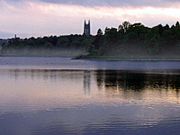
Newton is home to the Charles River, Crystal Lake, and the famous Heartbreak Hill. Many roads and highways serve the city, like Route 9 and the Mass Pike. The Green Line D branch of the MBTA also helps people get around.
The area that is now Newton was first settled in 1639. It was originally part of Cambridge. In 1681, it became its own town called Cambridge Village. It was renamed Newton in 1766 and became a city in 1874.
Contents
A Look at Newton's Past
How Newton Began: 17th Century
Newton was first part of a larger area called "the newe towne," settled in 1630. This area was later renamed Cambridge in 1638. The first English settlers arrived in what is now Newton in 1639.
A minister named John Eliot helped the Native American people of Nonantum move to Natick in 1651. He wanted to protect them from being taken advantage of by colonists. On December 15, 1681, Newton became a separate town called Cambridge Village. It was renamed Newtown in 1691 and finally Newton in 1766. On January 5, 1874, it officially became a city. Newton is often called The Garden City.
Growing Industries: 18th Century
In the late 1700s and early 1800s, small factories started in Newton. These factories used the power of water from the Newton Upper Falls and Newton Lower Falls. They made things like snuff, chocolate, glue, and paper. However, there wasn't enough water power for Newton to become a huge manufacturing city. Later, in 1902, the Stanley Motor Carriage Company, which made the Stanley Steamer cars, was located here.
Newton's Villages and Commuters: 19th Century
After the American Civil War, Newton was a mix of different villages. The northern villages, like Auburndale and West Newton, were wealthier. Other areas, like Waban, had fewer people.
Newton became one of the first "commuter suburbs" in North America. This means people lived in Newton but traveled to work in a bigger city. The Boston and Worcester railroad reached West Newton in 1834. Wealthy people from Boston built nice homes in Newton and used the train to get to work.
Modern Growth: 20th and 21st Centuries
More people moved to Newton when streetcar lines made it easier to travel in the late 1800s. Another big wave of growth happened in the 1920s when cars became more affordable. Even then, some parts of Newton, like Oak Hill, were still used for farming. By the 1950s, Newton became more crowded as more people moved in.
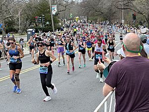
Today, Newton is well-known for being part of the Boston Marathon. Each April on Patriots' Day, runners pass through the city. They face the challenging "Newton Hills," including the famous Heartbreak Hill. Residents and visitors cheer on the runners along Washington Street and Commonwealth Avenue.
Newton's Location and Landscape
Newton is a suburban city about 7 mi (11 km) from downtown Boston. It is in Middlesex County. It shares borders with Waltham and Watertown to the north. To the south are Needham and the West Roxbury area of Boston. Wellesley and Weston are to the west. Brookline and the Brighton area of Boston are to the east.
The Charles River flows along the north and west sides of Newton. Route 128 goes through the western part of the city. The Mass Pike also passes through the northern part of Newton. Other important roads include Route 9 and Route 30 (Commonwealth Avenue).
Newton covers a total area of about 18.2 square miles (47.1 km2). Most of this is land, with a small amount of water.
How Newton's Land Was Formed
Newton is in the low-lying area of the Boston Basin. This area is surrounded by hills called drumlins. These hills were left behind after the last ice age, about twelve thousand years ago.
Newton has unique rock formations that show how the land has changed over millions of years. These changes include continents moving, ancient oceans, earthquakes, and volcanoes. The main types of rock are Roxbury Conglomerate, Cambridge Argillite or Slate, and Brighton Volcanics.
Newton's Hills and Villages
Newton is built around seven main hills. These hills are: Nonantum Hill, Waban Hill, Chestnut Hill, Bald Pate Hill, Oak Hill, Institution Hill, and Mount Ida. These hills are very clear and distinct.
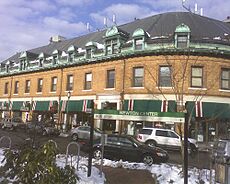
Instead of one main city center, Newton has thirteen different villages. Many of these villages have their own small downtown areas. The 13 villages are: Auburndale, Chestnut Hill, Newton Centre, Newton Corner, Newton Highlands, Newton Lower Falls, Newton Upper Falls, Newtonville, Nonantum, Oak Hill, Thompsonville, Waban and West Newton. Even though most villages have a post office, their exact borders are not officially set. This can sometimes be confusing for visitors.
Newton's Weather
Newton has a range of temperatures. The coldest temperature ever recorded was −21 °F (−29 °C) (about -29°C) in February 1934. The hottest temperature was 101 °F (38 °C) (about 38°C) in August 1975.
| Climate data for Newton, Massachusetts | |||||||||||||
|---|---|---|---|---|---|---|---|---|---|---|---|---|---|
| Month | Jan | Feb | Mar | Apr | May | Jun | Jul | Aug | Sep | Oct | Nov | Dec | Year |
| Record high °F (°C) | 68 (20) |
68 (20) |
89 (32) |
94 (34) |
93 (34) |
99 (37) |
100 (38) |
101 (38) |
99 (37) |
88 (31) |
81 (27) |
74 (23) |
101 (38) |
| Mean daily maximum °F (°C) | 34 (1) |
37 (3) |
44 (7) |
56 (13) |
66 (19) |
76 (24) |
82 (28) |
79 (26) |
72 (22) |
60 (16) |
50 (10) |
39 (4) |
58 (14) |
| Mean daily minimum °F (°C) | 17 (−8) |
19 (−7) |
27 (−3) |
38 (3) |
48 (9) |
57 (14) |
63 (17) |
62 (17) |
55 (13) |
43 (6) |
34 (1) |
24 (−4) |
41 (5) |
| Record low °F (°C) | −14 (−26) |
−21 (−29) |
−5 (−21) |
6 (−14) |
27 (−3) |
36 (2) |
44 (7) |
39 (4) |
28 (−2) |
20 (−7) |
5 (−15) |
−19 (−28) |
−21 (−29) |
| Average precipitation inches (mm) | 4.35 (110) |
4.24 (108) |
5.58 (142) |
4.55 (116) |
4.11 (104) |
4.31 (109) |
4.02 (102) |
4.03 (102) |
4.06 (103) |
4.69 (119) |
4.76 (121) |
4.89 (124) |
53.59 (1,360) |
Who Lives in Newton?
| Historical population | ||
|---|---|---|
| Year | Pop. | ±% |
| 1790 | 1,360 | — |
| 1800 | 1,491 | +9.6% |
| 1810 | 1,709 | +14.6% |
| 1820 | 1,850 | +8.3% |
| 1830 | 2,376 | +28.4% |
| 1840 | 3,351 | +41.0% |
| 1850 | 5,258 | +56.9% |
| 1860 | 8,382 | +59.4% |
| 1870 | 12,825 | +53.0% |
| 1880 | 16,995 | +32.5% |
| 1890 | 24,379 | +43.4% |
| 1900 | 33,587 | +37.8% |
| 1910 | 39,806 | +18.5% |
| 1920 | 46,054 | +15.7% |
| 1930 | 65,276 | +41.7% |
| 1940 | 69,873 | +7.0% |
| 1950 | 81,994 | +17.3% |
| 1960 | 92,384 | +12.7% |
| 1970 | 91,263 | −1.2% |
| 1980 | 83,622 | −8.4% |
| 1990 | 82,585 | −1.2% |
| 2000 | 83,829 | +1.5% |
| 2010 | 85,146 | +1.6% |
| 2020 | 88,923 | +4.4% |
| 2022* | 87,381 | −1.7% |
| * = population estimate. Source: United States Census records and Population Estimates Program data. Source: |
||
Population in 2020
In 2020, Newton had 88,923 people. The city is known for having many Jewish and Asian residents. About 21.9% of Newton's residents were born outside the United States in 2015.
| Race / Ethnicity (NH = Non-Hispanic) | Pop 2000 | Pop 2010 | Pop 2020 | % 2000 | % 2010 | % 2020 |
|---|---|---|---|---|---|---|
| White alone (NH) | 72,388 | 67,801 | 62,303 | 86.35% | 79.63% | 70.06% |
| Black or African American alone (NH) | 1,584 | 2,008 | 2,554 | 1.89% | 2.36% | 2.87% |
| Native American or Alaska Native alone (NH) | 43 | 56 | 49 | 0.05% | 0.07% | 0.06% |
| Asian alone (NH) | 6,415 | 9,759 | 14,681 | 7.65% | 11.46% | 16.51% |
| Pacific Islander alone (NH) | 18 | 18 | 25 | 0.02% | 0.02% | 0.03% |
| Some Other Race alone (NH) | 213 | 294 | 765 | 0.25% | 0.35% | 0.86% |
| Mixed Race or Multi-Racial (NH) | 1,057 | 1,734 | 4,053 | 1.26% | 2.04% | 4.56% |
| Hispanic or Latino (any race) | 2,111 | 3,476 | 4,493 | 2.52% | 4.08% | 5.05% |
| Total | 83,829 | 85,146 | 88,923 | 100.00% | 100.00% | 100.00% |
What Does Newton Do for Work?
Newton's biggest employers are Boston College and Newton-Wellesley Hospital. Many companies are based in Newton, including TechTarget and CyberArk. Until 2015, TripAdvisor, a very large travel website, had its main office in Newton. It then moved to nearby Needham.
Fun Things to See and Do in Newton
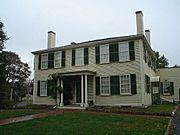
The Jackson Homestead.
|
- Crystal Lake is a 33-acre (13 ha) natural lake in Newton Centre. It has two small parks and a swimming area. People used to cut ice from the lake in winter to sell.
- The Jackson Homestead is a historic house built in 1809. It was a stop on the Underground Railroad, a secret network that helped enslaved people escape to freedom. Now it's a museum with old paintings, clothes, and maps.
- Heartbreak Hill is a very challenging part of the Boston Marathon. It's on Commonwealth Avenue.
- Newton has several exclusive golf courses, like Woodland Country Club and Brae Burn Country Club.
- Echo Bridge is a cool 19th-century stone bridge. It offers great views of the river and Hemlock Gorge.
- Norumbega Park in Auburndale used to be a popular amusement park. It opened in 1897 and closed in 1963. Its Totem Pole Ballroom was famous for big band music. Now, it's a popular place for walking dogs.
- Auburndale Cove is a picnic and recreation area on the Charles River.
- Chestnut Hill Reservoir is a popular park with beautiful views of the Boston skyline. It was designed by Frederick Law Olmsted, who also designed Central Park in New York City.
- Bullough's Pond is an old mill pond that became a pretty landscape feature. It was once used for ice skating.
- Newton has several "scenic roads" like Hobart Road and Waban Avenue. These roads have special rules to protect their trees and old stone walls.
- The First Baptist Church in Newton Centre, built in 1888, has a unique architectural style called Richardsonian Romanesque.
- The WHDH-TV tower is one of the tallest free-standing towers in the United States.
Learning in Newton
Public Schools
Newton has its own public school system called Newton Public Schools.
Elementary Schools
- Angier Elementary School
- Bowen Elementary School
- Burr Elementary School
- Cabot Elementary School
- Countryside Elementary School
- Franklin Elementary School
- Horace Mann Elementary School
- Lincoln Eliot Elementary School
- Mason Rice Elementary School
- Memorial Spaulding Elementary School
- Peirce Elementary School
- Underwood Elementary School
- Ward Elementary School
- Williams Elementary School
- Zervas Elementary School
Middle Schools
- Bigelow Middle School
- Brown Middle School
- Oak Hill Middle School
- F.A. Day Middle School
High Schools
- Newton North High School
- Newton South High School
Private Schools
- Fessenden School is a school for boys from kindergarten to 9th grade.
- Jackson School is a private Catholic elementary school.
- Newton Country Day School
- Schechter Boston is a Jewish day school for K-8.
- Wellan Montessori (formerly Newton Montessori School) is a private school for K-8.
- Mount Alvernia High School is a private girls' school for grades 7–12.
- Mount Alvernia Academy is an independent Catholic school for preschool through grade 6.
Colleges and Universities
Newton is home to several colleges and universities:
- Boston College in Chestnut Hill
- Boston College Law School in Newton Centre
- Hebrew College in Newton Centre
- Lasell University in Auburndale
- Mount Ida Campus of UMass Amherst in Oak Hill
- William James College in Oak Hill
Getting Around Newton
Newton has good public transportation run by the MBTA. You can use light rail, commuter rail, and bus service.
- The Green Line D branch (also called the Riverside branch) is a light rail line. It runs through the middle of the city and takes you to downtown Boston quickly.
- The Green Line B branch ends near Boston College, close to the Newton border.
- The MBTA Worcester commuter rail serves the northern villages of Newton. It offers train service to Boston.
- Many express buses also go to downtown Boston via the Massachusetts Turnpike.
Major highways like the Massachusetts Turnpike (Interstate 90) and Route 128 (Interstate 95) pass through Newton. Other important roads include Route 30 (Commonwealth Avenue) and Route 9.
Important Places and Services
Hospital
Newton-Wellesley Hospital is located on Washington Street. It is ranked as one of the best hospitals in the Boston area.
Cemeteries
- East Parish Burying Ground, also called Centre Street Cemetery, dates back to 1664.
- West Parish Burying Ground (River Street Cemetery) in West Newton.
- St. Mary's Episcopal Church and Cemetery, a private cemetery in Newton Lower Falls.
- South Burying Ground, also called Winchester Street Cemetery or Evergreen Cemetery.
- Newton Cemetery & Arboretum, a public cemetery in Newton Center.
Sister Cities
Newton has special connections with two other cities around the world:
 San Donato Val di Comino, Lazio, Italy
 San Juan del Sur, Nicaragua
See also
 In Spanish: Newton (Massachusetts) para niños
 | George Robert Carruthers |
 | Patricia Bath |
 | Jan Ernst Matzeliger |
 | Alexander Miles |


