
Wellesley, Massachusetts facts for kids
Quick facts for kids
Wellesley, Massachusetts
|
||
|---|---|---|

Wellesley Town Hall
|
||
|
||

Location of Wellesley in Norfolk County, Massachusetts
|
||

Wellesley, Massachusetts
Location in Massachusetts
|
||
| Settled | 1660 | |
| Incorporated | 1881 | |
| Government | ||
| • Type | Representative town meeting | |
| Area | ||
| • Total | 10.49 sq mi (27.2 km2) | |
| • Land | 10.18 sq mi (26.4 km2) | |
| • Water | 0.31 sq mi (0.8 km2) | |
| Elevation | 141 ft (43 m) | |
| Population
(2020)
|
||
| • Total | 29,550 | |
| • Density | 2,902.75/sq mi (1,120.76/km2) | |
| Time zone | UTC−5 (Eastern) | |
| • Summer (DST) | UTC−4 (Eastern) | |
| ZIP Codes |
02481, 02482, 02457
|
|
| Area code(s) | 339/781 | |
| FIPS code | 25-74175 | |
| GNIS feature ID | 0618332 | |

Wellesley is a town in Norfolk County, Massachusetts, United States. It is part of the larger Greater Boston area. In 2020, about 29,550 people lived here. Wellesley is known for its colleges, including Wellesley College, Babson College, and a campus of Massachusetts Bay Community College.
Contents
History of Wellesley
Wellesley started as part of Dedham, Massachusetts in the 1600s. Later, it became a section of Needham, Massachusetts called West Needham. On October 23, 1880, the people of West Needham decided to form their own town. The Massachusetts government officially named it Wellesley on April 6, 1881. The town got its name from the "Wellesley" estate of a generous local person named Horatio Hollis Hunnewell. The town's population grew a lot, by over 80%, around the 1920s.
Where is Wellesley Located?
Wellesley is in eastern Massachusetts. It shares borders with several other towns. To the east is Newton. To the north is Weston. Needham and Dover are to the south. To the west is Natick. The town covers about 10.49 square miles (27.17 km2). Most of this area is land, with a small part being water.
Wellesley's Neighborhoods
Wellesley has several different areas, each with its own feel.
- Wellesley Farms
- The Fells
- Wellesley Hills (ZIP code 02481)
- Wellesley Square (ZIP code 02482)
- Poets' Corner
- Babson Park (ZIP code 02457)
- Peirce Estates
- College Heights
- Wellesley Lower Falls
What is Wellesley's Climate Like?
Wellesley has a climate with warm summers. It gets a lot of humidity and precipitation (rain or snow) throughout the year.
| Climate data for Wellesley, Massachusetts | |||||||||||||
|---|---|---|---|---|---|---|---|---|---|---|---|---|---|
| Month | Jan | Feb | Mar | Apr | May | Jun | Jul | Aug | Sep | Oct | Nov | Dec | Year |
| Record high °F (°C) | 66 (19) |
67 (19) |
74 (23) |
82 (28) |
91 (33) |
95 (35) |
100 (38) |
97 (36) |
97 (36) |
87 (31) |
77 (25) |
66 (19) |
100 (38) |
| Mean daily maximum °F (°C) | 33.6 (0.9) |
34.7 (1.5) |
43.4 (6.3) |
54.9 (12.7) |
66.4 (19.1) |
74.7 (23.7) |
80 (27) |
78 (26) |
70.9 (21.6) |
60.5 (15.8) |
48.9 (9.4) |
37.4 (3.0) |
57.0 (13.9) |
| Daily mean °F (°C) | 26 (−3) |
26 (−3) |
33 (1) |
42 (6) |
53 (12) |
62 (17) |
68 (20) |
66 (19) |
60 (16) |
50 (10) |
39 (4) |
30 (−1) |
46 (8) |
| Mean daily minimum °F (°C) | 18.3 (−7.6) |
18.8 (−7.3) |
27 (−3) |
36.5 (2.5) |
46.4 (8.0) |
55.4 (13.0) |
61.5 (16.4) |
60.3 (15.7) |
53.4 (11.9) |
43.4 (6.3) |
33.7 (0.9) |
22.8 (−5.1) |
39.8 (4.3) |
| Record low °F (°C) | −14 (−26) |
−21 (−29) |
−5 (−21) |
6 (−14) |
27 (−3) |
31 (−1) |
44 (7) |
32 (0) |
28 (−2) |
20 (−7) |
5 (−15) |
−19 (−28) |
−21 (−29) |
| Average precipitation inches (mm) | 4.2 (110) |
3.9 (99) |
4.6 (120) |
4.1 (100) |
3.7 (94) |
3.6 (91) |
3.7 (94) |
4.1 (100) |
4 (100) |
4 (100) |
4.4 (110) |
4.4 (110) |
48.7 (1,228) |
| Average snowfall inches (cm) | 16.1 (41) |
16 (41) |
12 (30) |
3.1 (7.9) |
0.1 (0.25) |
0 (0) |
0 (0) |
0 (0) |
0 (0) |
0.3 (0.76) |
2.7 (6.9) |
11.7 (30) |
62 (157.81) |
| Average precipitation days | 12 | 11 | 13 | 12 | 12 | 12 | 11 | 10 | 9 | 10 | 11 | 12 | 135 |
| Source 1: Climate Summary for Dedham, Massachusetts | |||||||||||||
| Source 2: Monthly- All Data for Dedham, Massachusetts | |||||||||||||
People of Wellesley
| Historical population | ||
|---|---|---|
| Year | Pop. | ±% |
| 1890 | 3,600 | — |
| 1900 | 5,072 | +40.9% |
| 1910 | 5,413 | +6.7% |
| 1920 | 6,224 | +15.0% |
| 1930 | 11,439 | +83.8% |
| 1940 | 15,127 | +32.2% |
| 1950 | 20,549 | +35.8% |
| 1960 | 26,071 | +26.9% |
| 1970 | 28,051 | +7.6% |
| 1980 | 27,209 | −3.0% |
| 1990 | 26,615 | −2.2% |
| 2000 | 26,613 | −0.0% |
| 2010 | 27,982 | +5.1% |
| 2020 | 29,550 | +5.6% |
| 2023* | 30,733 | +4.0% |
| * = population estimate. Source: United States Census records and Population Estimates Program data. | ||
In 2000, there were 26,613 people living in Wellesley. About 8,594 households and 6,540 families called the town home. Many households (39.9%) had children under 18. Most households (67.2%) were married couples. The average household had 2.70 people. The median age was 38 years old.
Wellesley's Economy
Wellesley is home to many different businesses. These include local, national, and even global companies. Some well-known businesses with headquarters here are Benchmark Senior Living and Sun Life Financial U.S.
Top Employers in Wellesley
Many people work in Wellesley. Here are some of the biggest employers in the town:
| # | Employer | # of employees |
|---|---|---|
| 1 | Sun Life Financial | 1,209 |
| 2 | Wellesley College | 1,172 |
| 3 | Babson College | 961 |
| 4 | Harvard Pilgrim Health Care | 434 |
| 5 | Harvard Vanguard Medical Associates | 351 |
| 6 | Massachusetts Bay Community College | 287 |
| 7 | Dana Hall School | 269 |
| 8 | Whole Foods | 241 |
| 9 | Wellesley Country Club | 227 |
| 10 | Roche Bros. | 222 |
Arts and Culture in Wellesley
Historic Places in Wellesley
Wellesley has a special historic district on Cottage Street. Many houses there were built around the 1860s. These buildings are protected by the town's historic commission. This helps keep their old charm.
New Buildings and Changes
Wellesley has seen many new buildings and changes. An old inn was replaced by new homes and shops in 2006. The Wellesley Country Club built a new clubhouse in 2008. The old high school was replaced with a new one in 2012. A shopping area called Linden Street became "Linden Square." It now has a supermarket, restaurants, and stores.
Wellesley's Libraries
Wellesley opened a new Free Library building in 2003. It is part of the Minuteman Library Network. Two smaller branch libraries, one in Wellesley Hills and one in Wellesley Fells, closed in 2006. However, they reopened in September 2008. The main library was updated inside in 2021.
Education in Wellesley

Wellesley's schools often score higher than the state average on tests. The school system has a middle school and seven elementary schools. These elementary schools are Bates, Upham, Schofield, Fiske, Hardy, Hunnewell, and Sprague. Wellesley Middle School and Wellesley High School are the main schools. Their sports teams are called the Raiders.
There are also private schools in town. These include Tenacre Country Day School and St. John the Evangelist (a Catholic elementary school). Dana Hall School is a preparatory school just for girls. The Wellesley A Better Chance program helps young women from other areas attend Wellesley High School.
Wellesley is also home to three colleges:
- Wellesley College: A college for women focused on liberal arts.
- Massachusetts Bay Community College: A two-year public college.
- Babson: A college specializing in business.
In 2024, Upham elementary school closed after the Hunnewell and Hardy schools were rebuilt.
Green Schools in Wellesley
Wellesley Green Schools started in 2006. This group helps schools be more eco-friendly. Their "No Idling Campaign" won an award in 2014. The new high school, opened in 2012, is very green. It has a special roof with plants, uses geothermal energy, and has solar panels. It also collects rainwater.
Local News in Wellesley
You can find out what's happening in Wellesley from two local news sources. The Wellesley Townsman has been published since 1906. The Swellesley Report started in 2005. Both are available online. Old copies of the Townsman can be found at the Wellesley Free Library.
Transportation in Wellesley

Wellesley has had train service to Boston since 1833. Today, the MBTA provides commuter rail service. Trains run to Boston and to Framingham and Worcester. Wellesley has three train stations: Wellesley Farms, Wellesley Hills, and Wellesley Square. The Wellesley Farms station is a historic place. Bus service is also available along some streets.
Major roads like Interstate 95/Massachusetts Route 128, Massachusetts Route 9, Massachusetts route 16, and Massachusetts route 135 pass through Wellesley.
For older people and those with disabilities, there is a special MBTA service called The Ride. It offers door-to-door service by appointment. The Council on Aging also has a minibus service for elders. It takes them to medical places and the Woodland MBTA station. There's even a monthly minibus to the Natick Mall.
Wellesley's Power Plant
Wellesley gets its electricity from the Wellesley Municipal Light Plant. The three colleges in town pay extra for electricity from wind power. In 2012, Wellesley was named a Green Power Community by the U.S. Environmental Protection Agency. This means it uses a lot of clean energy.
Famous People from Wellesley


Many well-known people have lived in Wellesley. Here are a few:
- Danny Ainge: A former executive for the Boston Celtics basketball team.
- Ray Allen: A former basketball player for the Boston Celtics.
- Katharine Lee Bates: She wrote the famous song "America the Beautiful."
- Jane Curtin: A comedian and original cast member of Saturday Night Live.
- Nate Freiman: A former baseball player for the Oakland Athletics.
- Gordon Hayward: A basketball player for the Boston Celtics.
- Andrea Jung: A former CEO of Avon Products.
- Vladimir Nabokov: A famous Russian-American author.
- Sylvia Plath: A well-known poet and author of The Bell Jar.
- Richard Preston and Douglas Preston: Best-selling authors.
- Brad Stevens: A former coach and current general manager of the Boston Celtics.
- Biz Stone: A co-founder of Twitter.
- Steven Tyler: A rock musician, known from the band Aerosmith.
Images for kids
-
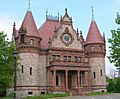
Wellesley Town Hall
-

Seal of Wellesley, Massachusetts
-
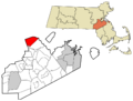
Location of Wellesley in Norfolk County, Massachusetts
See also
 In Spanish: Wellesley (Massachusetts) para niños
