
List of regions of the United States facts for kids
The United States is a huge country! To make it easier to understand, people divide it into different areas called regions. These regions can be defined in many ways. Some regions are set by the government for official reasons. Others are based on shared culture, history, or how people earn a living.
Contents
- Official Regions of the United States
- Unofficial Regions
- Intrastate and Intraterritory Regions
- Images for kids
- See also
Official Regions of the United States
Census Bureau Regions

Since 1950, the United States Census Bureau has divided the country into four main statistical regions. These regions are often used when collecting and analyzing information about the country. Each region is then split into smaller divisions.
- Region 1: Northeast
- Division 1: New England (Connecticut, Maine, Massachusetts, New Hampshire, Rhode Island, and Vermont)
- Division 2: Middle Atlantic (New Jersey, New York, and Pennsylvania)
- Region 2: Midwest (This was called the North Central Region before 1984.)
- Division 3: East North Central (Illinois, Indiana, Michigan, Ohio, and Wisconsin)
- Division 4: West North Central (Iowa, Kansas, Minnesota, Missouri, Nebraska, North Dakota, and South Dakota)
- Region 3: South
- Division 5: South Atlantic (Delaware, Florida, Georgia, Maryland, North Carolina, South Carolina, Virginia, Washington, D.C., and West Virginia)
- Division 6: East South Central (Alabama, Kentucky, Mississippi, and Tennessee)
- Division 7: West South Central (Arkansas, Louisiana, Oklahoma, and Texas)
- Region 4: West
- Division 8: Mountain (Arizona, Colorado, Idaho, Montana, Nevada, New Mexico, Utah, and Wyoming)
- Division 9: Pacific (Alaska, California, Hawaii, Oregon, and Washington)
It's important to know that Puerto Rico and other U.S. territories are not part of these Census Bureau regions or divisions.
Federal Reserve Bank Districts

The Federal Reserve Act was passed in 1913. It divided the country into twelve districts. Each district has a main Federal Reserve Bank. These twelve banks work together to form the Federal Reserve System. This system acts as the central bank for the United States. Missouri is the only state that has two Federal Reserve locations within its borders. However, parts of other states can also belong to more than one district.
- Boston
- New York
- Philadelphia
- Cleveland
- Richmond
- Atlanta
- Chicago
- St. Louis
- Minneapolis
- Kansas City
- Dallas
- San Francisco
Time Zones

The United States is so wide that it has many different time zones. This helps keep track of time across the country.
- UTC−12:00 (Baker Island, Howland Island)
- Samoa Time Zone (American Samoa, Jarvis Island, Kingman Reef, Midway Atoll, Palmyra Atoll)
- Hawaii–Aleutian Time Zone (Hawaii, Aleutian Islands (Alaska), Johnston Atoll)
- Alaska Time Zone (Alaska, excluding Aleutian Islands)
- Pacific Time Zone
- Arizona Time Zone (excluding the Navajo Nation)
- Mountain Time Zone (excluding most parts of Arizona)
- Central Time Zone
- Eastern Time Zone
- Atlantic Time Zone (Puerto Rico, U.S. Virgin Islands)
- Chamorro Time Zone (Guam, Northern Mariana Islands)
- Wake Island Time Zone (Wake Island)
Courts of Appeals Circuits

The U.S. legal system divides the country into different circuits for its Courts of Appeals. These courts hear appeals from lower courts.
- First Circuit
- Second Circuit
- Third Circuit
- Fourth Circuit
- Fifth Circuit
- Sixth Circuit
- Seventh Circuit
- Eighth Circuit
- Ninth Circuit
- Tenth Circuit
- Eleventh Circuit
- D.C. Circuit
The Federal Circuit is different. It handles specific types of cases from all over the country, not just one region.
Agency Administrative Regions
In 1969, the government tried to make it easier for different federal agencies to work together. They created ten "Standard Federal Regions." Even though this system was officially stopped in 1995, some agencies still use it. Examples include the Environmental Protection Agency (EPA) and the Department of Housing and Urban Development (HUD).
EPA Regions and Offices

Region I
Office location: Boston States: Connecticut, Maine, Massachusetts, New Hampshire, Rhode Island, and Vermont
Region II
Office location: New York City States: New York, New Jersey, Puerto Rico, and the Virgin Islands
Region III
Office location: Philadelphia States: Delaware, District of Columbia, Maryland, Pennsylvania, Virginia, and West Virginia
Region IV
Office location: Atlanta States: Alabama, Florida, Georgia, Kentucky, Mississippi, North Carolina, South Carolina, and Tennessee
Region V
Office location: Chicago States: Illinois, Indiana, Minnesota, Michigan, Ohio, and Wisconsin
Region VI
Office location: Dallas States: Arkansas, Louisiana, New Mexico, Oklahoma, and Texas
Region VII
Office location: Kansas City States: Iowa, Kansas, Missouri, and Nebraska
Region VIII
Office location: Denver States: Colorado, Montana, North Dakota, South Dakota, Utah, and Wyoming
Region IX
Office location: San Francisco States: Arizona, California, Hawaii, Nevada, Guam, and American Samoa
Region X
Office location: Seattle States: Alaska, Idaho, Oregon, and Washington
Unofficial Regions
These regions are not set by the government. Instead, they are areas that people recognize because they share similar features. This could be their geography, culture, or history.
Multi-State Regions
These regions stretch across several states.
- Appalachia (a mountain region in the eastern U.S.)
- Cascadia (includes parts of Oregon, Washington, and Canada)
- Deep South (a cultural region in the southeastern U.S.)
- Great Lakes Region (around the Great Lakes)
- Great Plains (a large, flat area in the central U.S.)
- New England (a historic region in the northeastern U.S.)
- Rocky Mountains (a major mountain range)
- Sun Belt (a warm region in the southern and western U.S.)
- Tornado Alley (an area where tornadoes are common)
The Belts
Some unofficial regions are called "belts" because they form a long strip across the country. They are often named after what they are known for.
- Bible Belt (known for strong religious beliefs)
- Corn Belt (where a lot of corn is grown)
- Rust Belt (an older industrial area)
- Snowbelt (gets a lot of snow)
- Sun Belt (a warm, sunny region)
Interstate Megalopolises
- Further information: Megalopolis
A megalopolis is a very large urban area. It is formed when several big cities and their suburbs grow together.
- California (includes cities like Los Angeles and San Francisco)
- Great Lakes (around cities like Chicago and Detroit)
- Northeast (from Boston to Washington, D.C.)
Interstate Metropolitan Areas
These are large city areas that cross state lines.
- Baltimore–Washington metropolitan area (includes Washington, D.C., and parts of Maryland, Virginia, West Virginia, and Pennsylvania)
- Greater Boston (parts of Massachusetts, Rhode Island, and New Hampshire)
- Chicago metropolitan area (parts of Illinois, Indiana, and Wisconsin)
- Kansas City metropolitan area (parts of Missouri and Kansas)
- New York metropolitan area (parts of New York, New Jersey, Connecticut, and Pennsylvania)
Intrastate and Intraterritory Regions
Each state and territory also has its own unique regions. These are smaller areas within a single state or territory. Here are a few examples:
Alabama

Alaska

Arizona

- Arizona Strip
- Grand Canyon
- Phoenix metropolitan area
- Southern Arizona
California
California is a very large state with many distinct regions. These include coastal areas, mountains, deserts, and valleys.
Colorado

- Colorado Eastern Plains
- Colorado Plateau
- Denver Metropolitan Area
- Front Range Urban Corridor
- Southern Rocky Mountains
Florida


Florida has many regions, often named for their location or features.
- Central Florida
- North Florida
- Northwest Florida
- South Florida
- Florida Keys
- Florida Panhandle
- Space Coast
- Tampa Bay Area
Hawaii


Hawaii is made up of many islands, each with its own unique areas.
Illinois

- Central Illinois
- Chicago metropolitan area
- Southern Illinois (sometimes called Little Egypt)
Louisiana

- Acadiana (known for Cajun culture)
- Central Louisiana
- Greater New Orleans
- North Louisiana
Michigan

Michigan is divided into two main parts: the Lower Peninsula and the Upper Peninsula.
Lower Peninsula
Upper Peninsula
New York

1. Western New York – counties: Niagara, Erie, Chautauqua, Cattaraugus, Allegany
2. Finger Lakes – counties: Orleans, Genesee, Wyoming, Monroe, Livingston, Wayne, Ontario, Yates, Seneca
3. Southern Tier – counties: Steuben, Schuyler, Chemung, Tompkins, Tioga, Chenango, Broome, Delaware
4. Central New York – counties: Cortland, Cayuga, Onondaga, Oswego, Madison
5. North Country – counties : St. Lawrence, Lewis, Jefferson, Hamilton, Essex, Clinton, Franklin
6. Mohawk Valley – counties: Oneida, Herkimer, Fulton, Montgomery, Otsego, Schoharie
7. Capital District – counties : Albany, Columbia, Greene, Warren, Washington, Saratoga, Schenectady, Rensselaer
8. Hudson Valley – counties: Sullivan, Ulster, Dutchess, Orange, Putnam, Rockland, Westchester
9. New York City – counties (boroughs): New York (Manhattan), Bronx (The Bronx), Queens (Queens), Kings (Brooklyn), Richmond (Staten Island)
10. Long Island – counties: Nassau, Suffolk
New York State has many distinct regions, from its famous city to vast wilderness.
- Downstate New York
- Upstate New York
- Western New York
- Finger Lakes
- Adirondack Mountains
North Carolina

North Carolina is often divided into three main geographic regions.
- Western North Carolina (mountainous)
- Central North Carolina (rolling hills)
- Eastern North Carolina (coastal plains)
Oklahoma

Oregon


Oregon's regions are shaped by its mountains, valleys, and coast.
Pennsylvania
- Coal Region
- Delaware Valley (Philadelphia area)
- Dutch Country
- Pittsburgh metropolitan area
- The Poconos
Puerto Rico
.png)
Puerto Rico is a U.S. territory with its own distinct areas.
South Carolina
- The Lowcountry (coastal)
- The Midlands (central)
- The Upstate (mountainous)
- Grand Strand (beach area)
South Dakota

South Dakota is often split by the Missouri River.
- East River
- West River
- Badlands
- Black Hills
Tennessee
Tennessee is officially divided into three "Grand Divisions."
Texas

Texas is a very large state, so it has many different regions.
- Central Texas
- Gulf Coast
- East Texas
- North Texas
- South Texas
- West Texas
- Texas Panhandle
U.S. Minor Outlying Islands

These are small, uninhabited islands and atolls that belong to the U.S.
U.S. Virgin Islands
Virginia

- Eastern Shore
- Hampton Roads
- Northern Virginia
- Shenandoah Valley
- Southwest Virginia
Washington
- Central Washington
- Eastern Washington
- Olympic Peninsula
- Puget Sound
- Western Washington
Wisconsin

Wisconsin has five main geographic regions.
- Central Plain
- Eastern Ridges and Lowlands
- Lake Superior Lowland
- Northern Highland
- Western Upland
Images for kids
-
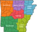
Regions of Arkansas
-
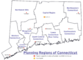
Map highlighting the 9 official regions of Connecticut
-
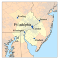
The Delaware Valley
-
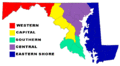
Maryland's regions
-
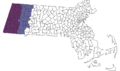
The Berkshire region of Massachusetts
-
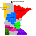
Regions of Minnesota
-
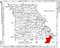
The Missouri Bootheel
-
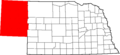
The Nebraska Panhandle


See also
 In Spanish: Regiones de Estados Unidos para niños
- Geography of the United States
- Historic regions of the United States
- List of metropolitan areas of the United States
- Media market, e.g., Nielsen Designated Market Area
- Political divisions of the United States
- Regional stock exchanges of the United States
- United States territory
- Vernacular geography
