
Southeast Alaska facts for kids
Quick facts for kids Lingít"People of the Tides" |
|
|---|---|
| People | Tlingit |
| Language | Lingít |
| Country | Tlingit Aaní |


Southeast Alaska, also known as the Alaska panhandle, is a unique part of the U.S. state of Alaska. It shares borders with the Canadian province of British Columbia and a small part of Yukon. Much of this area is called Tlingit Aaní, which means "People of the Tides' land." It is also home to the Tongass National Forest, the largest national forest in the United States. The border with Canada often follows the high Boundary Ranges of the Coast Mountains. This region is known for its amazing scenery and its mild, rainy climate.
The largest cities in Southeast Alaska are Juneau (which is also the state capital), Sitka, and Ketchikan. You can also find Hyder here, which is the easternmost town in Alaska.
Contents
Geography of Southeast Alaska
Southeast Alaska covers about 35,138 square miles (91,000 square kilometers) of land. It includes many islands that make up the Alexander Archipelago. The biggest islands, from north to south, are Chichagof Island, Admiralty Island, Baranof Island, Kupreanof Island, Revillagigedo Island, and Prince of Wales Island.
Important waterways in this region include Glacier Bay, Lynn Canal, Icy Strait, Chatham Strait, Stephens Passage, Frederick Sound, Sumner Strait, and Clarence Strait.
This area is the northern end of the Inside Passage. This is a protected water route with many winding passages between islands and fjords. It starts in Puget Sound in Washington state. Long ago, it was a vital travel path for Tlingit, Haida, and Tsimshian Native peoples. Later, it was used by steamships during the gold rush. Today, it is an important route for Alaska Marine Highway ferries and cruise ships.
People and Population

.jpg)
Southeast Alaska has seven full boroughs and two census areas. It also includes part of the Yakutat Borough. Even though it has only about 6% of Alaska's land, it is larger than the state of Maine.
In 2010, about 71,616 people lived in Southeast Alaska. This was about 10% of Alaska's total population. Almost half of these residents lived in Juneau, the state capital. By 2018, nine towns in Southeast Alaska had at least 1,000 people.
Main Cities and Towns
Here are some of the major cities and towns in Southeast Alaska, with their populations from the 2020 Census:
- Juneau - 32,255 people
- Sitka - 8,458 people
- Ketchikan - 8,192 people
- Petersburg - 3,043 people
- Wrangell - 2,127 people
- Haines - 1,657 people
- Metlakatla - 1,454 people
- Skagway - 1,240 people
- Craig - 1,036 people
Protected Natural Areas

Southeast Alaska is home to several important protected areas:
- The Tongass National Forest: This huge forest includes the Admiralty Island National Monument and Misty Fjords National Monument.
- Glacier Bay National Park: This is the sixth largest national park in the United States.
- Sitka National Historical Park: This park protects important historical sites.
On August 20, 1902, President Theodore Roosevelt created the Alexander Archipelago Forest Reserve. This reserve became the main part of the Tongass National Forest, which covers most of the region.
Other protected areas include:
- Glacier Bay National Park and Preserve
- Klondike Gold Rush National Historical Park
- Sitka National Historical Park
- Part of Wrangell–St. Elias National Park and Preserve (the most southeastern section)
- Admiralty Island National Monument
- Misty Fjords National Monument
Climate and Weather

The climate in Southeast Alaska is mostly a mild, rainy oceanic climate. In the central area around Juneau, it is a marine sub-polar climate. The far northwest and high inland areas have a subarctic climate.
Southeast Alaska is the only part of Alaska where the average daytime high temperature stays above freezing during the winter months. This is true except for some southern parts of the Aleutian islands.
Ecology and Wildlife
Southeast Alaska is a temperate rain forest. It is part of a larger rain forest zone that stretches from northern California to Prince William Sound. The most common trees here are sitka spruce and western hemlock.
The wildlife in this region is diverse. You can find brown bears, black bears, special Alexander Archipelago wolf packs, Sitka black-tailed deer, humpback whales, orcas, and five different kinds of salmon. Many birds also live here, such as bald eagles, harlequin ducks, scoters, and marbled murrelets.
An Ecological Atlas of Southeast Alaska was published in 2016. It gives a good overview of the region's landscape, birds, wildlife, and how people use the land. It also talks about climate change.
Culture and History

This area is the traditional home of the Tlingit. It is also where Haida historically settled and where Tsimshian people live today. The region has strong economic and cultural ties to Seattle and the American Pacific Northwest.
The border between Alaska and the Canadian province of British Columbia was once a source of disagreement. This was known as the Alaska boundary dispute. The United States and the United Kingdom had different ideas about where the border should be.
Industries and Economy
The main industries in Southeast Alaska are commercial fishing and tourism. Tourism mostly comes from the cruise ship industry.
Logging
Logging was a very important industry in the past. However, it has been decreasing because of competition and the closing of major pulp mills in the region.
Mining
Mining is still important in the northern part of Southeast Alaska. Gold was discovered here in 1880 and played a big role in the early history of the region.
In recent years, new mines have been explored and built in nearby British Columbia. These mines are located upstream of important rivers like the Unuk and the Stikine. This has led to discussions about how to manage shared resources with Canada.
Healthcare
Major hospitals in the region include Bartlett Regional Hospital in Juneau and PeaceHealth Ketchikan Medical Center in Ketchikan. The Southeast Alaska Regional Health Consortium runs healthcare facilities in 27 communities.
Shipbuilding
Because of the many fishing boats and ferries in the region, building and maintaining ships is an important part of the economy. Ketchikan has a shipbuilding yard owned by Vigor Industrial.
Tourism
Tourists mainly visit Southeast Alaska in the summer, usually by cruise ship. Cruise ships operate from April to October. In 2019, about 1.3 million people visited Alaska by cruise ship.
Many cruises start in Seattle or Vancouver, Canada. They stop in places like Ketchikan, Juneau, and Skagway. Some trips end in Whittier or Seward.
The cruise ship industry became popular in the 1960s. A businessman named Stanley B. McDonald started Princess Cruises. His company began offering leisure cruises to Southeast Alaska by 1969. The TV show The Love Boat helped make cruising even more popular.
Transportation

Southeast Alaska has very rugged, mountainous land. Because of this, most communities do not have road connections to other towns. So, airplanes and boats are the main ways to travel. The Alaska Marine Highway ferry system travels through this region.
Air Travel
Alaska Airlines is the biggest airline in the region. Juneau International Airport is the main airport for all of Southeast Alaska. Ketchikan International Airport is another important hub for the southern part of the region.
Smaller "bush airlines" and "air taxis" serve many of the smaller, isolated communities and villages. Many places can only be reached by floatplane. This is because it is often hard to build proper runways on the steep island slopes.
Water Travel
Southeast Alaska is mainly served by the state-run Alaska Marine Highway. This ferry system connects towns like Skagway, Haines, Hoonah, Juneau, Sitka, Petersburg, Wrangell, and Ketchikan with Prince Rupert, BC and Bellingham, Washington.
The Inter-Island Ferry Authority, based on Prince of Wales Island, offers the only scheduled passenger and car ferry service to that island. Small companies also offer marine passenger service. The area is very busy with cruise ship traffic during the summer.
Images for kids
-
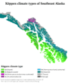
Köppen climate types in southeast Alaska
See also
 In Spanish: Mango de Alaska para niños
