
Metlakatla, Alaska facts for kids
Quick facts for kids
Metlakatla, Alaska
Maxłakxaała
|
|
|---|---|

View of Metlakahtla, Alaska in 1889
|
|

Location of Metlakatla, Alaska
|
|
| Country | United States |
| State | Alaska |
| Borough | Unorganized |
| Census Area | Prince of Wales-Hyder |
| Area | |
| • Total | 2.33 sq mi (6.02 km2) |
| • Land | 2.31 sq mi (5.97 km2) |
| • Water | 0.02 sq mi (0.05 km2) |
| Elevation | 3 ft (1 m) |
| Population
(2020)
|
|
| • Total | 1,454 |
| • Density | 630.53/sq mi (243.49/km2) |
| Time zone | UTC−9 (AKST) |
| • Summer (DST) | UTC−8 (AKDT) |
| ZIP code |
99926
|
| Area code(s) | 907 |
| FIPS code | 02-48870 |
| GNIS feature ID | 1423661 |
Metlakatla is a small community located on Annette Island in Alaska, United States. It is a "census-designated place" (CDP), which means it's a special area defined by the government for counting people. In 2020, about 1,454 people lived there.
Metlakatla is important because it is the main settlement of the Metlakatla Indian Community. This community manages the Annette Island Reserve, which is the only remaining Native American reserve in Alaska. The people of Metlakatla chose to keep their land and water rights. Most members of the community are Tsimshian people, but others from different Alaskan Native tribes can join if approved.
Contents
History of Metlakatla
.jpeg)
The name Metlakatla comes from the Tsimshian language, meaning "saltwater passage." The village was named after an older village in British Columbia, Canada. Long ago, this area was a hunting ground for the Tlingit people. The Tsimshian people were given permission by the Tlingit tribe to live on the land.
A New Home in Alaska

.jpeg)
In 1886, a Scottish missionary named William Duncan had disagreements with church leaders in Metlakatla, British Columbia. He and a group of his Tsimshian followers decided to leave. Duncan traveled to Washington, D.C., and asked the U.S. government for land in Alaska.

The U.S. government, led by President Cleveland, gave them Annette Island. The Tsimshian people had found this island perfect because it had a calm bay, easy-to-reach beaches, a waterfall, and lots of fish.
Building the Community
In 1887, the group arrived on Annette Island and began building their new home in the Port Chester area. They designed the town with a European-style grid layout. They built a church, a school, a cannery (for preserving fish), and a sawmill. They first called it New Metlakatla, but later dropped the "New."
In 1888, William Duncan asked the U.S. Congress to make Annette Island an Indian reserve. Even though this system wasn't common in Alaska, Congress agreed in 1891. Duncan stayed in Metlakatla until he passed away in 1918.

Metlakatla During World War II
During World War II, the United States made an agreement with the Metlakatla Indian Community. This agreement allowed the U.S. to build a military airbase on Annette Island. In return, the U.S. promised to build a road connecting the town to Alaska's Inside Passage. This road would allow ferry service to Ketchikan all year round. Canadian forces were stationed at the airfield during the war, helping to defend American territory.
After the war, the airfield became a United States Coast Guard base for search and rescue missions. It also served as a commercial airport until the 1970s, when a new airport was built in Ketchikan.
Unique Land Rights
The Annette Islands Reserve is the only Indian Reserve in Alaska. In the 1970s, the Metlakatla community chose not to accept the Alaska Native Claims Settlement Act. This decision allowed them to keep their special Reserve status and control over their land and waters. The Annette Islands Reserve includes 132,000 acres of land and water. The Metlakatla Indian Community has special rights to fish commercially and for their own use in the waters around the islands.
Connecting to Metlakatla
Most people travel to Metlakatla by taking the Alaska Marine Highway ferry. You can also go to Ketchikan on Revillagigedo Island and then cross the water to Annette Island by boat or seaplane.
More than 50 years after World War II, in 1997, the U.S. government finally started building the road they had promised. From 1997 to 2007, different parts of the U.S. military worked together to build a 15-mile road across Annette Island. Soldiers, sailors, airmen, and marines took turns working on the road for a few weeks at a time.
Geography and Climate
.jpeg)
Metlakatla is located in Port Chester Bay on Annette Island. It is about 25 kilometers (15 miles) south of Ketchikan. The area is mostly land, with a small amount of water.
Metlakatla has a wet and windy climate all year. Winters are cool, and summers are mild. It's one of the warmest places in Alaska because of its location near the ocean. It rains a lot, especially in October and November. Snow falls mostly from November to March. The temperature rarely drops below freezing. The warmest temperature ever recorded was 93°F (34°C) in June 2004, and the coldest was -4°F (-20°C) in January 1947.
Population Information
| Historical population | |||
|---|---|---|---|
| Census | Pop. | %± | |
| 1890 | 823 | — | |
| 1900 | 465 | −43.5% | |
| 1910 | 602 | 29.5% | |
| 1920 | 574 | −4.7% | |
| 1930 | 466 | −18.8% | |
| 1940 | 674 | 44.6% | |
| 1950 | 817 | 21.2% | |
| 1960 | 798 | −2.3% | |
| 1970 | 1,050 | 31.6% | |
| 1980 | 1,056 | 0.6% | |
| 1990 | 1,407 | 33.2% | |
| 2000 | 1,375 | −2.3% | |
| 2010 | 1,405 | 2.2% | |
| 2020 | 1,454 | 3.5% | |
| U.S. Decennial Census | |||
Metlakatla first appeared in the U.S. Census in 1890. Over the years, the spelling of the name changed a few times, but it has been "Metlakatla" since 1970.
In 2000, there were 1,375 people living in Metlakatla. About 81.8% of the people were Native American, and 9.5% were White. The community had 469 households, and many of them (38.8%) had children under 18. The average household had about three people. The median age was 31 years old.
The median income for a household in Metlakatla was about $43,516 per year. This means half the households earned more than this, and half earned less. About 8% of the population lived below the poverty line.
Education
The Annette Island School District serves the students in Metlakatla. There is also a free program for adults to get their GED (General Educational Development) diploma, which is like a high school equivalency.
Images for kids
-
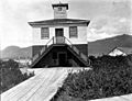
Jail and Fire Department, early 20th century
See also
 In Spanish: Metlakatla (Alaska) para niños
