
Ketchikan, Alaska facts for kids
Quick facts for kids
Ketchikan
Kichx̱áan
|
|||
|---|---|---|---|
|
View of the Newtown area
Downtown in 2013
Front Street
Burkhart-Dibrell House
City Hall
Sign over Mission Street
|
|||
|
|||
| Nickname(s):
Salmon Capital of the World, Rain Capital of Alaska, Alaska's First City
|
|||

Ketchikan
Location in Alaska
|
|||
| Country | |||
| State | |||
| Borough | Ketchikan Gateway | ||
| Incorporated | August 25, 1900 | ||
| Area | |||
| • Total | 4.90 sq mi (12.70 km2) | ||
| • Land | 3.81 sq mi (9.88 km2) | ||
| • Water | 1.09 sq mi (2.82 km2) | ||
| Elevation | 0 ft (0 m) | ||
| Population
(2020)
|
|||
| • Total | 8,192 | ||
| • Density | 2,147.88/sq mi (829.19/km2) | ||
| • City and Borough | 13,477 | ||
| • City and Borough Estimate (2014) | 13,787 | ||
| Time zone | UTC−9 (AKST) | ||
| • Summer (DST) | UTC−8 (AKDT) | ||
| ZIP codes |
99901, 99950
|
||
| Area code | 907 | ||
| FIPS code | 02-38970 | ||
| GNIS feature ID | 1423039, 2419408 | ||


.jpg)

.jpg)


Ketchikan is a city in Alaska, located on Revillagigedo Island. It's known as the "Salmon Capital of the World" and the "Rain Capital of Alaska" because it gets a lot of rain. It's also called "Alaska's First City" because it was one of the earliest cities to be officially formed in Alaska.
In 2020, about 8,192 people lived in Ketchikan. The city is named after Ketchikan Creek, which flows through the town. The name "Ketchikan" comes from the Tlingit language, but its exact meaning is not fully clear.
Contents
History of Ketchikan

Long ago, Tlingit people used the area around Ketchikan Creek as a summer camp for fishing. The modern town started in 1885 when Mike Martin came to the area. He was sent by a company to see if it was a good place for fishing businesses. He and George Clark started a fish processing business and a general store.
Ketchikan became important because of its location. It's at the southern end of the Inside Passage, a water route connecting the Gulf of Alaska to Puget Sound. This made it a key stop for ships and earned it the nickname "Alaska's first city."
Amazing Totem Poles
.jpeg)
Ketchikan is famous for having the world's largest collection of standing totem poles. You can see them all over the city and at special parks. Some of the main places to find them are Saxman Totem Park, Totem Bight State Park, Potlatch Park, and the Totem Heritage Center.
Many of the totem poles at Saxman and Totem Bight are new carvings of older poles. This was part of a project during the 1930s to preserve Native American art. The Totem Heritage Center has very old totem poles from the 1800s that were saved from old village sites nearby. One special totem pole, the Chief Kyan pole in Whale Park, is even featured in the background of most US passports!
Geography of Ketchikan


Ketchikan is in the very southern part of Southeast Alaska. It's on Revillagigedo Island, which was named in 1793. The city is about 700 miles (1,126 km) northwest of Seattle, Washington.
The city is long and narrow because of the steep, forested land. Most of the buildings are right along the waterfront. The land goes from sea level up to about 300 feet (91 meters) high. Deer Mountain, a 3,001-foot (915-meter) peak, is right next to the downtown area.
Ketchikan is separated from Gravina Island by a channel called the Tongass Narrows. The Ketchikan International Airport is located on Gravina Island.
Ketchikan's Climate

Ketchikan has a mild ocean climate. This means it has a lot of cloudy days, high humidity, and plenty of rain all year. This is why it's called the "Rain Capital of Alaska."
Winters are cool but not extremely cold. The average temperature in January is about 35.6°F (2°C). Summers are mild, with an average temperature of about 59.0°F (15°C) in August.
Ketchikan gets a lot of rain, averaging about 149.54 inches (3,798 mm) each year. The rainiest months are usually in the autumn and winter. The most rain ever recorded in one year was 202.55 inches (5,144.77 mm) in 1949!
| Climate data for Ketchikan, Alaska (Ketchikan International Airport), 1991–2020 normals, extremes 1910–present | |||||||||||||
|---|---|---|---|---|---|---|---|---|---|---|---|---|---|
| Month | Jan | Feb | Mar | Apr | May | Jun | Jul | Aug | Sep | Oct | Nov | Dec | Year |
| Record high °F (°C) | 62 (17) |
63 (17) |
69 (21) |
75 (24) |
93 (34) |
96 (36) |
92 (33) |
89 (32) |
80 (27) |
72 (22) |
65 (18) |
62 (17) |
96 (36) |
| Mean maximum °F (°C) | 50.4 (10.2) |
49.9 (9.9) |
53.5 (11.9) |
61.3 (16.3) |
70.8 (21.6) |
76.1 (24.5) |
76.3 (24.6) |
75.3 (24.1) |
67.9 (19.9) |
59.1 (15.1) |
52.5 (11.4) |
49.6 (9.8) |
79.6 (26.4) |
| Mean daily maximum °F (°C) | 39.7 (4.3) |
40.9 (4.9) |
43.6 (6.4) |
49.8 (9.9) |
56.9 (13.8) |
61.3 (16.3) |
64.5 (18.1) |
64.7 (18.2) |
58.9 (14.9) |
51.1 (10.6) |
43.7 (6.5) |
40.2 (4.6) |
51.3 (10.7) |
| Daily mean °F (°C) | 35.6 (2.0) |
36.2 (2.3) |
38.0 (3.3) |
43.5 (6.4) |
50.1 (10.1) |
55.3 (12.9) |
58.8 (14.9) |
59.0 (15.0) |
53.6 (12.0) |
46.2 (7.9) |
39.7 (4.3) |
36.4 (2.4) |
46.0 (7.8) |
| Mean daily minimum °F (°C) | 31.5 (−0.3) |
31.5 (−0.3) |
32.4 (0.2) |
37.2 (2.9) |
43.3 (6.3) |
49.3 (9.6) |
53.2 (11.8) |
53.3 (11.8) |
48.3 (9.1) |
41.3 (5.2) |
35.6 (2.0) |
32.6 (0.3) |
40.8 (4.9) |
| Mean minimum °F (°C) | 13.7 (−10.2) |
18.3 (−7.6) |
19.2 (−7.1) |
27.9 (−2.3) |
33.4 (0.8) |
40.0 (4.4) |
45.6 (7.6) |
44.7 (7.1) |
37.5 (3.1) |
29.7 (−1.3) |
22.6 (−5.2) |
18.1 (−7.7) |
7.3 (−13.7) |
| Record low °F (°C) | −7 (−22) |
2 (−17) |
3 (−16) |
12 (−11) |
25 (−4) |
31 (−1) |
36 (2) |
34 (1) |
28 (−2) |
17 (−8) |
5 (−15) |
−1 (−18) |
−7 (−22) |
| Average precipitation inches (mm) | 16.17 (411) |
11.80 (300) |
10.98 (279) |
10.25 (260) |
8.68 (220) |
7.02 (178) |
7.33 (186) |
11.30 (287) |
14.30 (363) |
18.37 (467) |
17.07 (434) |
16.27 (413) |
149.54 (3,798) |
| Average precipitation days (≥ 0.01 in) | 22.0 | 17.0 | 20.6 | 19.4 | 16.1 | 16.4 | 16.0 | 16.8 | 19.5 | 22.8 | 23.6 | 22.4 | 232.6 |
| Source 1: NOAA | |||||||||||||
| Source 2: National Weather Service | |||||||||||||
People of Ketchikan
| Historical population | |||
|---|---|---|---|
| Census | Pop. | %± | |
| 1890 | 40 | — | |
| 1900 | 459 | 1,047.5% | |
| 1910 | 1,613 | 251.4% | |
| 1920 | 2,458 | 52.4% | |
| 1930 | 3,796 | 54.4% | |
| 1940 | 4,695 | 23.7% | |
| 1950 | 5,305 | 13.0% | |
| 1960 | 6,483 | 22.2% | |
| 1970 | 6,994 | 7.9% | |
| 1980 | 7,198 | 2.9% | |
| 1990 | 8,263 | 14.8% | |
| 2000 | 7,922 | −4.1% | |
| 2010 | 8,050 | 1.6% | |
| 2020 | 8,192 | 1.8% | |
| U.S. Decennial Census | |||
Ketchikan first appeared in the U.S. Census in 1890. It was called "Kichikan" then and had 40 residents. It became an official city in 1900.

In 2010, there were 8,050 people living in Ketchikan. The city is home to a mix of different cultures. Many people are White, and a good number are Native American, including Tlingit and Haida. There's also a notable Asian population, especially Filipino.
The city has a good balance of different age groups. About 24% of the people are under 18 years old. Most people in Ketchikan speak English. Other languages spoken include Tagalog, Spanish, and Tsimshian.
Media and News
Ketchikan has several ways to get local news and entertainment. There are four radio stations: KTKN-AM 930, KGTW-FM 106.7, KFMJ-FM 99.9, and KRBD-FM 105.3, which is a community-owned NPR station.
There's also a local TV station, KUBD, which is a CBS network channel. For printed news, Ketchikan has its own newspaper, the Ketchikan Daily News.
Ketchikan Public Utilities also provides local cable TV. This includes broadcasts of public meetings, local sports, history shows, and a calendar of upcoming events.
Ketchikan's Economy
.jpeg)
.jpeg)
Ketchikan is an important port for entering Alaska. Its economy has always relied on fishing, especially canneries, and also on tourism, government jobs, and forestry. Many people work in these areas, with more jobs available during the busy summer tourist season.
Today, Ketchikan's economy is mainly based on government services, tourism, and commercial fishing. It's often called the "Salmon Capital of the World" because of its strong fishing industry.
Many tourists visit Ketchikan, especially by cruise ship. In 2018, over a million visitors came to Ketchikan by cruise ship! A popular show for tourists is the Great Alaskan Lumberjack Show, where performers show off lumberjack skills.
The Misty Fiords National Monument is a big attraction nearby. The Tongass National Forest also has its main office in Ketchikan. For many years, a large part of Ketchikan's economy came from the Ketchikan Pulp Company, a wood pulp mill. The mill closed in 1997.

Lumber Industry
The Ketchikan Pulp Company (KPC) had a large pulp mill near Ketchikan. It opened in 1954. In the 1990s, the company faced issues for releasing wastewater into the waters around Ward Cove.
The mill closed in 1997. This meant that many jobs were lost in the area, which had a big impact on the local economy.
Marine Industry

Ketchikan has a shipyard that builds and repairs ships. It has two large dry-docks. In 2010, the shipyard launched a special ferry called the M/V Susitna. It also got a contract to build two new ferries for the Alaska Marine Highway system.
.jpeg)
Power and Communication
Ketchikan Public Utilities (KPU) is a city-owned company that provides power and telecommunications services. Other companies like GCI and Alaska Power and Telephone Company (AP&T) also provide services in the area.
Transportation in Ketchikan


Ketchikan is a key place for travel by air and sea in southern Southeast Alaska.
The Ketchikan International Airport connects Ketchikan to other cities like Seattle, Juneau, Sitka, and Anchorage. It's also a hub for smaller planes that fly to nearby communities. It's easy for travelers from the rest of the U.S. to reach Ketchikan by plane.
Ketchikan is also a major port for two ferry lines. The Alaska Marine Highway System connects Ketchikan to other Alaskan ports and to Prince Rupert, British Columbia in Canada. You can also take a ferry to Bellingham, Washington. Another ferry, the M/V Lituya, travels daily between Ketchikan and Metlakatla. The Inter-Island Ferry Authority also provides daily service from Hollis on Prince of Wales Island.
Education in Ketchikan
Colleges and Universities
Ketchikan has a campus of the University of Alaska Southeast. It used to be called Ketchikan Community College. The campus has two buildings named after important people from Ketchikan's past.
Public Schools
The Ketchikan Gateway Borough School District serves the city. It includes:
- Ketchikan High School
- Revilla Junior/Senior High School
- Schoenbar Middle School
Sister Cities

Ketchikan has a sister city relationship with Palm Desert, California.
It also used to have a sister city in Japan, called Kanayama. Even though Kanayama is now part of a larger city called Gero, Ketchikan and Kanayama still have an educational exchange program. Every year, teachers and students travel between Ketchikan and Kanayama to learn about each other's cultures and languages.
Notable People from Ketchikan
- Danny Edwards (born 1951), a professional golfer.
- Nathan Jackson (born 1938), a Tlingit artist famous for carving totem poles.
- Roy Jones (1893–1974), the first person to fly commercially in Alaska.
- Jerry Mackie (born 1962), an Alaska state politician and businessman.
- Tallie Medel, an actress.
- Frank Murkowski (born 1933), a former United States Senator and Governor of Alaska. He grew up in Ketchikan.
- Lisa Murkowski (born 1957), daughter of Frank Murkowski and also a U.S. Senator. She was born in Ketchikan.
- Rudy Pankow (born 1998), an American actor.
- William Paul (1885–1977), a Tlingit leader and the first Alaska Native to become an attorney.
- Ray Troll (born 1954), an artist known for his fish-themed drawings.
- Don Watts (born 1956 or 1957), a farmer and entrepreneur.
Images for kids
-
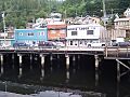
Ketchikan as seen from the dock near the cruise terminal.
-
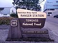
The Ketchikan Misty Fjords Ranger station.
-
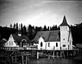
St John's Episcopal Church and a mission hospital in August 1904.


.jpeg)
See also
 In Spanish: Ketchikan para niños
