
Prince Rupert, British Columbia facts for kids
Quick facts for kids
Prince Rupert
|
|||
|---|---|---|---|
| City of Prince Rupert | |||

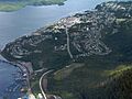
Aerial view of Prince Rupert
|
|||
|
|||
| Nicknames:
Rainforest City, City of Rainbows
|
|||

Prince Rupert
Location in British Columbia

Prince Rupert
Location in Canada
|
|||
| Country | Canada | ||
| Province | British Columbia | ||
| Regional District | North Coast | ||
| Incorporated | March 10, 1910 | ||
| Named for | Prince Rupert of the Rhine | ||
| Area | |||
| • City | 54.93 km2 (21.21 sq mi) | ||
| • Metro | 222.94 km2 (86.08 sq mi) | ||
| Elevation | 40 m (130 ft) | ||
| Population
(2016)
|
|||
| • City | 12,220 | ||
| • Density | 227.7/km2 (590/sq mi) | ||
| • Metro | 13,052 | ||
| • Metro density | 58.5/km2 (152/sq mi) | ||
| Time zone | UTC– 08:00 (PST) | ||
| • Summer (DST) | UTC– 07:00 (PDT) | ||
| Forward sortation area |
V8J
|
||
| Area code(s) | 250, 778, 236, 672 | ||


Prince Rupert is a port city in British Columbia, Canada. It's located on Kaien Island, close to the Alaskan panhandle. This city is a major hub for land, air, and water transportation on British Columbia's North Coast. In 2016, about 12,220 people lived there.
Contents
History of Prince Rupert
Early History and Founding

People from the Coast Tsimshian First Nation have lived in the Prince Rupert Harbour area for at least 5,000 years. Around 1500 B.C., more people moved here, building larger villages and houses. However, by the early 1830s, the Coast Tsimshian's influence in the area began to lessen.
Prince Rupert was chosen as the end point for the Grand Trunk Pacific Railway, a big train project. It took the place of other towns like Port Simpson and Port Essington as the main business center for the North Coast.
The railway company bought land from First Nations and received more land from the BC government. In 1906, a post office was set up. Workers began surveying and clearing land to build the town. The local government helped by providing money for sidewalks, roads, sewers, and water pipes. Building on Kaien Island was expensive because the ground was wet and rocky.
By 1909, the town had many stores, two banks, a hotel, and places to eat. The first land sales caused a lot of excitement and competition.
Prince Rupert officially became a city on March 10, 1910. It was named after Prince Rupert of the Rhine, who was the first governor of the Hudson's Bay Company. He never visited Canada, but his name was chosen in a national competition.
After a real estate boom ended in 1912 and World War I began, much of the railway company's land remained unsold. The company also planned a large hotel and train station, but these were never built. Charles Melville Hays, the president of the railway, made some poor business choices that led to the company's financial troubles. Mount Hays, a mountain on Kaien Island, and a local high school are named after him. The Prince Rupert station, a historic building, was finished in 1922.
Prince Rupert in the 20th and 21st Centuries
Local leaders promised a highway connecting Prince Rupert to the mainland, which helped the city grow. During World War II, US troops finished the road to Terrace. This helped move many allied soldiers to the Aleutian Islands and the Pacific. Several forts were built to protect Prince Rupert during the war.

After World War II, the main industries in Prince Rupert became fishing (especially for salmon and halibut) and forestry. From 1912 until the early 1980s, Prince Rupert was known as the "halibut capital of the world." There was a long disagreement between American and Canadian fishermen over fishing rights, which led to the creation of the 54-40 or Fight Society. The United States Coast Guard still has a base nearby in Ketchikan, Alaska.
In 1949, a large 1949 Queen Charlotte earthquake shook the area, causing windows to break and buildings to sway.
In the summer of 1958, there was a riot in Prince Rupert due to racial discrimination. People were unhappy with how police treated Aboriginal people. After an Aboriginal couple was arrested, about 1,000 people protested, breaking windows and clashing with police. This event was serious enough that the Riot Act was read, which is very rare in Canada.
For many years, students often worked in the profitable fishing industry to help pay for their schooling. A pulp mill was built and started operating in 1951. In 1958, a sawmill was also opened. In the 1960s, most people in Prince Rupert worked in fishing or at the sawmill. Later, terminals for shipping coal and grain were built. From the 1960s to the 1980s, the city added many new facilities, like a civic centre, swimming pool, public library, golf course, and a performing arts center. These changes helped Prince Rupert grow from a small town into a city.
In the 1990s, both the fishing and forestry industries faced big problems. In 1997, Canadian fishermen blocked an Alaskan ferry to protest salmon fishing rights. The forestry industry also struggled due to a trade dispute with the USA. When the pulp mill closed, many people lost their jobs. Prince Rupert's population, which had reached about 18,000 in the early 1990s, started to shrink as people left to find work.
The years from 1996 to 2004 were tough for Prince Rupert. However, things started to improve around 2005. A new container port was announced, the pulp mill got new owners, a new cruise ship dock opened in 2004, and coal and grain shipping became popular again. These changes, along with new tourism, suggest a bright future for Prince Rupert. The port is now an important hub for trade across the Pacific Ocean.
Geography of Prince Rupert
Prince Rupert is located on Kaien Island, about 770 kilometers (478 miles) northwest of Vancouver. It's just north of the mouth of the Skeena River and is connected to the mainland by a short bridge. The city sits on the island's northwestern shore, facing Prince Rupert Harbour.
Prince Rupert is the western end of Trans-Canada Highway 16, also known as the Yellowhead Highway. It is about 16 km (10 mi) west of Port Edward, 144 km (89 mi) west of Terrace, and 715 km (444 mi) west of Prince George.
Climate and Weather
Prince Rupert has an oceanic climate, which means it has mild temperatures and lots of rain. It's also in a temperate rainforest. Prince Rupert is often called "The City of Rainbows" because it's Canada's wettest city. On average, it gets about 2,620 millimeters (103 inches) of rain each year. It rains on about 240 days a year, and the city only gets about 1,230 hours of sunshine annually, making it one of the least sunny places in Canada.
Summers in Prince Rupert are mild and not as rainy, with an average temperature of 13.8°C (56.8°F) in August. Winters are cool and damp, but they are milder than most places at the same latitude because of the Pacific Ocean. The average temperature in January is 2.4°C (36.3°F).
Snowfall is moderate for Canada, with about 126 centimeters (50 inches) falling each year, mostly from December to March. Snow usually melts within a few days, but sometimes big snowstorms can bring a lot of snow. The winds are often strong, usually blowing from the southeast.
The hottest temperature ever recorded in Prince Rupert was 32.2°C (90.0°F) on June 6, 1958. The coldest temperature ever recorded was -24.4°C (-11.9°F) on January 4, 1965.
| Climate data for Prince Rupert (Prince Rupert Airport) Climate ID: 1066481; coordinates 54°17′33″N 130°26′41″W / 54.29250°N 130.44472°W; elevation: 35.4 m (116 ft); 1981–2010 normals, extremes 1908–present |
|||||||||||||
|---|---|---|---|---|---|---|---|---|---|---|---|---|---|
| Month | Jan | Feb | Mar | Apr | May | Jun | Jul | Aug | Sep | Oct | Nov | Dec | Year |
| Record high humidex | 17.2 | 18.6 | 17.9 | 22.8 | 29.3 | 27.8 | 29.1 | 31.6 | 28.5 | 23.4 | 19.3 | 16.1 | 31.6 |
| Record high °C (°F) | 17.8 (64.0) |
18.9 (66.0) |
20.0 (68.0) |
25.5 (77.9) |
29.4 (84.9) |
32.2 (90.0) |
30.6 (87.1) |
30.0 (86.0) |
27.0 (80.6) |
21.7 (71.1) |
20.0 (68.0) |
18.9 (66.0) |
32.2 (90.0) |
| Mean daily maximum °C (°F) | 5.6 (42.1) |
6.1 (43.0) |
7.7 (45.9) |
10.2 (50.4) |
12.6 (54.7) |
14.7 (58.5) |
16.2 (61.2) |
17.0 (62.6) |
14.9 (58.8) |
11.1 (52.0) |
7.3 (45.1) |
5.5 (41.9) |
10.8 (51.4) |
| Daily mean °C (°F) | 2.4 (36.3) |
2.7 (36.9) |
4.2 (39.6) |
6.4 (43.5) |
9.0 (48.2) |
11.6 (52.9) |
13.4 (56.1) |
13.8 (56.8) |
11.5 (52.7) |
8.0 (46.4) |
4.3 (39.7) |
2.7 (36.9) |
7.5 (45.5) |
| Mean daily minimum °C (°F) | −0.8 (30.6) |
−0.7 (30.7) |
0.6 (33.1) |
2.5 (36.5) |
5.4 (41.7) |
8.4 (47.1) |
10.5 (50.9) |
10.6 (51.1) |
8.0 (46.4) |
4.9 (40.8) |
1.3 (34.3) |
−0.2 (31.6) |
4.2 (39.6) |
| Record low °C (°F) | −24.4 (−11.9) |
−18.1 (−0.6) |
−17.2 (1.0) |
−7.1 (19.2) |
−3.7 (25.3) |
1.1 (34.0) |
0.6 (33.1) |
2.8 (37.0) |
−2.2 (28.0) |
−11.3 (11.7) |
−20.6 (−5.1) |
−22.8 (−9.0) |
−24.4 (−11.9) |
| Record low wind chill | −34 | −25 | −23 | −11 | −5 | −1 | 1 | 0 | −6 | −17 | −28 | −31 | −34 |
| Average precipitation mm (inches) | 276.3 (10.88) |
185.6 (7.31) |
199.6 (7.86) |
172.4 (6.79) |
137.6 (5.42) |
108.8 (4.28) |
118.7 (4.67) |
169.1 (6.66) |
266.3 (10.48) |
373.6 (14.71) |
317.0 (12.48) |
294.2 (11.58) |
2,619.1 (103.11) |
| Average rainfall mm (inches) | 252.9 (9.96) |
167.1 (6.58) |
188.4 (7.42) |
169.6 (6.68) |
137.5 (5.41) |
108.7 (4.28) |
118.7 (4.67) |
169.1 (6.66) |
266.3 (10.48) |
373.4 (14.70) |
306.9 (12.08) |
271.7 (10.70) |
2,530.4 (99.62) |
| Average snowfall cm (inches) | 25.6 (10.1) |
19.3 (7.6) |
11.8 (4.6) |
2.8 (1.1) |
0.1 (0.0) |
0.0 (0.0) |
0.0 (0.0) |
0.0 (0.0) |
0.0 (0.0) |
0.3 (0.1) |
9.7 (3.8) |
22.8 (9.0) |
92.4 (36.4) |
| Average precipitation days (≥ 0.2 mm) | 22.5 | 18.5 | 21.7 | 19.6 | 18.3 | 17.3 | 17.5 | 17.5 | 19.8 | 24.2 | 23.8 | 22.8 | 243.5 |
| Average rainy days (≥ 0.2 mm) | 20.4 | 16.4 | 20.3 | 19.4 | 18.3 | 17.3 | 17.5 | 17.5 | 19.8 | 24.2 | 23.4 | 21.5 | 235.9 |
| Average snowy days (≥ 0.2 cm) | 5.0 | 4.2 | 3.6 | 1.2 | 0.08 | 0.0 | 0.0 | 0.0 | 0.04 | 0.20 | 2.9 | 4.6 | 21.7 |
| Average relative humidity (%) (at 1500 LST) | 78.5 | 71.5 | 68.1 | 67.7 | 71.2 | 75.0 | 77.6 | 77.7 | 76.1 | 77.5 | 77.6 | 80.2 | 74.9 |
| Mean monthly sunshine hours | 40.1 | 65.2 | 103.0 | 145.8 | 171.1 | 154.5 | 149.7 | 149.7 | 115.7 | 72.4 | 43.0 | 32.1 | 1,242.1 |
| Percent possible sunshine | 16.2 | 23.8 | 28.1 | 34.6 | 34.5 | 30.1 | 29.1 | 32.4 | 30.2 | 22.1 | 16.7 | 13.9 | 26.0 |
| Source: Environment and Climate Change Canada (January maximum) (March maximum) (May maximum) (June maximum) (July minimum) (August maximum) (November maximum) | |||||||||||||
Population and People
In the 2021 Canadian census, Prince Rupert had a population of 12,300 people. This was a small increase from its 2016 population of 12,220. The city has a land area of 66 square kilometers (25 square miles).
Here's how the population has changed over the years:
|
|
|
||||||||||||||||||||||||||||||||||||||||||||||||||||||||||||||||||||||||||||||||||||||||||||||||
Here's a look at the population by age group in 2004:
- Under 18 years = 28.2%
- 18 – 34 years = 22.0%
- 35 – 54 years = 32.8%
- 55 – 74 years = 13.6%
- 75 years and over = 3.4%
The average age was 34.8 years.
Different Backgrounds in Prince Rupert
Prince Rupert is home to people from many different backgrounds. In the 2001 Canadian census, Prince Rupert had the highest percentage of First Nations people among Canadian cities with a population of 5,000 or more.
The table below shows the different ethnic groups in Prince Rupert over the years:
| Panethnic group |
2021 | 2016 | 2011 | 2006 | 2001 | 1996 | 1991 | 1986 | |||||||||||
|---|---|---|---|---|---|---|---|---|---|---|---|---|---|---|---|---|---|---|---|
| Pop. | % | Pop. | % | Pop. | % | Pop. | % | Pop. | % | Pop. | % | Pop. | % | Pop. | % | ||||
| European | 5,780 | 47.44% | 5,850 | 48.73% | 6,190 | 50.08% | 6,915 | 54.24% | 8,580 | 59.05% | 10,250 | 61.64% | 10,950 | 66.12% | 11,695 | 75.52% | |||
| Indigenous | 4,545 | 37.3% | 4,670 | 38.9% | 4,745 | 38.39% | 4,475 | 35.1% | 4,330 | 29.8% | 4,415 | 26.55% | 3,990 | 24.09% | 2,835 | 18.31% | |||
| Southeast Asian |
810 | 6.65% | 640 | 5.33% | 570 | 4.61% | 390 | 3.06% | 605 | 4.16% | 730 | 4.39% | 420 | 2.54% | 125 | 0.81% | |||
| South Asian |
660 | 5.42% | 405 | 3.37% | 410 | 3.32% | 535 | 4.2% | 545 | 3.75% | 610 | 3.67% | 425 | 2.57% | 480 | 3.1% | |||
| East Asian |
165 | 1.35% | 285 | 2.37% | 315 | 2.55% | 355 | 2.78% | 340 | 2.34% | 455 | 2.74% | 655 | 3.96% | 315 | 2.03% | |||
| African | 45 | 0.37% | 65 | 0.54% | 90 | 0.73% | 50 | 0.39% | 35 | 0.24% | 35 | 0.21% | 25 | 0.15% | 5 | 0.03% | |||
| Middle Eastern |
40 | 0.33% | 15 | 0.12% | 0 | 0% | 0 | 0% | 0 | 0% | 15 | 0.09% | 25 | 0.15% | N/A | N/A | |||
| Latin American |
30 | 0.25% | 25 | 0.21% | 0 | 0% | 10 | 0.08% | 45 | 0.31% | 50 | 0.3% | 70 | 0.42% | 30 | 0.19% | |||
| Other | 85 | 0.7% | 50 | 0.42% | 20 | 0.16% | 25 | 0.43% | 55 | 0.38% | 75 | 0% | N/A | N/A | N/A | N/A | |||
| Total responses |
12,185 | 99.07% | 12,005 | 98.24% | 12,360 | 98.82% | 12,750 | 99.49% | 14,530 | 99.23% | 16,630 | 99.5% | 16,560 | 99.64% | 15,485 | 98.29% | |||
| Total population |
12,300 | 100% | 12,220 | 100% | 12,508 | 100% | 12,815 | 100% | 14,643 | 100% | 16,714 | 100% | 16,620 | 100% | 15,755 | 100% | |||
| Note: Totals greater than 100% due to multiple origin responses | |||||||||||||||||||
Religion in Prince Rupert
Based on the 2021 Canadian census, here are the main religious groups in Prince Rupert:
- No religion (6,825 people or 56.0%)
- Christianity (4,335 people or 35.6%)
- Sikhism (415 people or 3.4%)
- Buddhism (190 people or 1.6%)
- Hinduism (165 people or 1.4%)
- Islam (95 people or 0.8%)
- Indigenous Spirituality (30 people or 0.2%)
- Judaism (15 people or 0.1%)
Education in Prince Rupert
Prince Rupert is part of BC School District 52, which also includes Port Edward. There is a Coast Mountain College campus in Prince Rupert, which also serves as a campus for the University of Northern British Columbia.
Famous People from Prince Rupert
Many notable people have connections to Prince Rupert:
- Thomas Dufferin "Duff" Pattullo: A politician who was mayor of Prince Rupert and later the Premier of British Columbia (from 1933 to 1941).
- Alexander Malcolm Manson: The first lawyer in Prince Rupert. He became a politician, serving as Speaker of the House and later as Attorney-General. He was also appointed to the British Columbia Supreme Court.
- Iona Campagnolo: A politician who served on the Prince Rupert City Council. She was elected to the federal government and became the Minister of Amateur Sports in 1976. Later, she was the Lieutenant-Governor of British Columbia from 2001 to 2007.
- Dan Miller: A politician who represented the Prince Rupert Electoral District. He served as Premier from August 1999 to February 2000.
- Frederick Peters: A former Premier of Prince Edward Island, who worked as the City Solicitor for Prince Rupert from 1911 to 1919.
- Rod Brind'Amour: A former captain of the NHL's Carolina Hurricanes.
- Lisa Walters: An LPGA golf champion.
- Paul Wong: A Canadian video artist.
- Sid Dickens: An artist.
- Gloria Macarenko: A Canadian journalist and co-anchor for CBC Vancouver.
- Takao Tanabe: A painter.
- Bernice Liu: An actress and singer.
- John S. MacDonald: A university professor and founder of MacDonald, Dettwiler and Associates Ltd.
- Don Yeomans: A Haida artist.
Industries in Prince Rupert
Prince Rupert's economy mainly depends on the fishing industry, its port, and tourism.
Transportation in Prince Rupert
Seaport Facilities

Prince Rupert's port is special because it has the deepest ice-free natural harbour in North America, and the third deepest natural harbor in the world. It is the closest North American port to many places in Asia. This makes it a key stop for some cargo ships traveling between Asia and North America. The port also has a special barge service called the CN Aquatrain that carries train cargo between Prince Rupert and Whittier, Alaska.
Passenger ferries also operate from Prince Rupert. BC Ferries offers trips to the Haida Gwaii islands and to Port Hardy on Vancouver Island. The Alaska Marine Highway ferries travel to Ketchikan, Juneau, Sitka, and other ports along Alaska's Inside Passage. The Prince Rupert Ferry Terminal is right next to the Prince Rupert railway station. From here, Via Rail has a train service that runs three times a week to Prince George and Jasper.
The Prince Rupert Port Authority manages the port's operations.
Much of the harbor is protected by Digby Island, where the Prince Rupert Airport is located. The city itself is on Kaien Island. The harbor also includes several smaller basins and is part of the waters of Chatham Sound, which includes Ridley Island.
Port Facilities and Services
.jpg)
Prince Rupert is a great location for a port because of its very deep natural harbor. The port can handle a lot of cargo, similar to the Port of Vancouver. Unlike many other west coast ports, Prince Rupert usually doesn't have much traffic congestion. Also, because the surrounding area is very mountainous with narrow channels, Prince Rupert is the only good port location in the inland passage region.
The Prince Rupert Port Authority (PRPA) is a government agency that runs the port properties.
Some of the main facilities at the PRPA port include:
- Atlin Terminal
- Northlands Terminal
- Lightening Dock
- Ocean Dock
- Westview Dock
- Fairview Terminal
- Prince Rupert Grain
- Trigon Pacific Terminals (formerly Ridley Terminals)
- Sulphur Corporation
All these facilities are connected by CN Rail.
The Canadian Coast Guard has a base in Prince Rupert Harbour called CCG Base Seal Cove. They keep vessels there for search and rescue missions and to maintain navigation aids (like buoys and lighthouses) along the north coast. The Coast Guard also uses helicopters from Prince Rupert to reach remote locations and operates a Marine Communications Centre that helps manage ship traffic in a large area.
Both BC Ferries and the Alaska Marine Highway have ferries that stop in Prince Rupert. These ferries travel to places in the Alaska Panhandle, the Haida Gwaii islands, and small communities along the central coast to the south.
Airport Access
The Prince Rupert Airport (YPR/CYPR) is located on Digby Island. To get to the airport, you usually take a bus from downtown Prince Rupert, which then travels to Digby Island by ferry. The airport has one runway and one passenger terminal. Air Canada offers flights to Prince Rupert from Vancouver International Airport.
Prince Rupert also has the Prince Rupert/Seal Cove Water Aerodrome, which is a seaplane facility. It offers regular and chartered flights to nearby villages and remote areas.
Railway Connections
CN Rail has a main railway line that goes to Prince Rupert from Valemount, British Columbia. In Valemount, this line connects with the main CN line from Vancouver. Freight trains on the Prince Rupert line mostly carry grain, coal, wood products, chemicals, and containers. As the port of Prince Rupert continues to be updated, train traffic on CN is expected to increase.
Additionally, Via Rail operates the Jasper – Prince Rupert train three times a week. This train connects Prince Rupert with Prince George and Jasper. The trip takes two days, with an overnight stop in Prince George, so passengers can enjoy the scenery during daylight hours. In Jasper, passengers can connect to Via's The Canadian train, which travels between Toronto and Vancouver.
Communications
Telephone, mobile, and Internet services in Prince Rupert are provided by CityWest (formerly CityTel). CityWest is owned by the City of Prince Rupert. They also offer long-distance phone service.
In 2005, CityTel became an independent company called CityWest. It then bought a local cable company, which helped CityWest serve more communities in northwest British Columbia.
In 2008, Rogers Communications started offering mobile phone service in the area, which was the first real competition for CityWest. This led CityWest to partner with Bell Canada to offer digital mobile services.
In 2013, CityWest and TELUS announced that CityWest would stop offering its own mobile service and partner with TELUS. This allowed CityWest customers to use TELUS' 4G wireless network.
Media
Radio Stations
- AM 860 – CFPR, CBC Radio One
- FM 98.1 – VF2119, classic rock (repeats CFNR-FM, Terrace)
- FM 99.1 – CHTK-FM, EZ Rock 99.1
- FM 100.7 – CIAJ-FM, Christian programming
- FM 101.9 – CJFW-FM-2, country music (repeats CJFW-FM, Terrace)
Television Channels
- Channel 6 – CFTK-TV-1, CTV 2 (repeats CFTK-TV, Terrace)
Newspapers
- Prince Rupert Daily News: A daily newspaper that was published from 1911 to 2010.
- The Northern View: A local weekly newspaper that started in 2006.
- The Northern Connector: A regional weekly newspaper that covers Prince Rupert, Kitimat, and Terrace areas, also started in 2006.
Tourist Attractions

Prince Rupert is a key spot on the Inside Passage, which is a route of calm waters along the Pacific coast from Vancouver, British Columbia to Skagway, Alaska. Many cruise ships visit Prince Rupert in the summer as they travel between Alaska and Seattle.
Prince Rupert is also a great place to start wildlife viewing trips. You can see whales, eagles, salmon, and grizzly bears. The Khutzeymateen Grizzly Bear sanctuary nearby has one of the largest populations of grizzly bears in North America. You can arrange tours by boat, float plane, or land from Prince Rupert.
Nearby Communities
Prince Rupert is a starting point for visiting many other places:
- Dodge Cove (1 km or 0.6 mi west)
- Metlakatla (5 km or 3 mi west)
- Port Edward (15 km or 9 mi south)
- Lax Kw'alaams (Port Simpson) (30 km or 19 mi northwest)
- Oona River (43 km or 27 mi southwest)
- Kitkatla (65 km or 40 mi south)
- Kisumkalum (140 km or 87 mi east)
- Kitselas (142 km or 88 mi east)
- Terrace (146 km or 91 mi east)
- Hartley Bay (157 km or 98 mi southeast)
The Haida Gwaii islands are to the west of Prince Rupert, across the Hecate Strait. Alaska is 49 nautical miles (91 km or 56 mi) north of Prince Rupert.
Images for kids
-
Aerial view of Prince Rupert
-

Flag of Prince Rupert, British Columbia
-

Coat of Arms of Prince Rupert
