
Haida Gwaii facts for kids
|
Nickname: "Queen Charlottes"
"The Charlottes" |
|
|---|---|
.jpg)
|
|

Map of Haida Gwaii
|
|

Haida Gwaii
Location in British Columbia
|
|
| Geography | |
| Location | Pacific Ocean |
| Coordinates | 53°N 132°W / 53°N 132°W |
| Total islands | c. 150 |
| Major islands |
|
| Area | 10,180 km2 (3,930 sq mi) |
| Highest elevation | 1,164 m (3,819 ft) |
| Highest point | Mount Moresby |
|
Canada
|
|
| Province | British Columbia |
| Largest settlement | Village of Daajing Giids (pop. 964) |
| Demographics | |
| Population | 4,526 (2021) |
| Pop. density | 0.445 /km2 (1.153 /sq mi) |
| Additional information | |
| Time zone | |
Haida Gwaii (Haida: X̱aaydag̱a Gwaay.yaay / X̱aayda gwaay), which means "Islands of the Haida people", is a group of islands off the northern Pacific coast of British Columbia, Canada. These islands are about 55 to 125 kilometers away from the mainland. A shallow body of water called the Hecate Strait separates them from the rest of British Columbia. To the south is Queen Charlotte Sound, and to the north, the Dixon Entrance separates Haida Gwaii from Alaska.
Haida Gwaii is made up of two main islands: Graham Island (Kiis Gwaay) in the north and Moresby Island (Haida: T'aawxii X̱aaydag̱a Gwaay.yaay linag̱waay, lit. 'south people island half', or Gwaay Haanas "Islands of Beauty") in the south. There are also about 400 smaller islands. Together, they cover an area of about 10,180 square kilometers. Other important islands include Anthony Island (Sg̱ang Gwaay), Burnaby Island (Sg̱aay Kun Gwaay.yaay), Langara Island (Kiis Gwaay), Lyell Island (Athlii Gwaii), Louise Island, (Ḵ'uuna Gwaay), Alder Island, and Kunghit Island (G̱angx̱id Gwaay).
For a long time, these islands were known as the Queen Charlotte Islands. This name was given by a British explorer named George Dixon in 1787. However, on June 3, 2010, the islands were officially renamed Haida Gwaii. This change was part of an agreement between British Columbia and the Haida people, recognizing their deep connection to the land.
People have lived on these islands for at least 13,000 years. Haida Gwaii is the homeland of the Haida Nation. Today, about half of the people living on the islands are Haida. The Council of the Haida Nation was created in 1974. Its goal is to help the Haida Nation be independent and self-sufficient. In 2024, the government of British Columbia transferred ownership of over 200 islands to the Haida people. This was a big step in recognizing the Haida Nation's traditional land rights.
Some parts of the islands are protected. For example, Gwaii Haanas National Park Reserve and Haida Heritage Site covers the southern part of Moresby Island and many smaller islands. This park has beautiful coastal rainforests and mountains. Another protected area is Naikoon Provincial Park on Graham Island. Haida Gwaii is home to unique wildlife. This includes a large type of black bear and the smallest type of ermine, both found only on these islands.
Contents
Haida Gwaii: Islands of the Haida People
Discovering Haida Gwaii's Geography
Haida Gwaii is an archipelago, which means it's a group of many islands. It sits in the Pacific Ocean off the coast of British Columbia, Canada. The islands are separated from the mainland by a body of water called the Hecate Strait.
The Two Main Islands
The two largest islands are Graham Island in the north and Moresby Island in the south. Graham Island is known as Kiis Gwaay by the Haida people. Moresby Island is also called Gwaay Haanas, meaning "Islands of Beauty." Besides these two, there are around 400 smaller islands.
A Rich History of the Haida Nation
The Haida people have lived on these islands for a very long time. Their history here goes back at least 13,000 years. The islands are the heart of the Haida Nation.
Early Life on the Islands
The Haida people developed a rich culture. They used the abundant resources from the land and sea. They were skilled seafarers and traders. They had strong communities in over 100 villages across the islands. The Haida also had established trade routes with other First Nations along the coast.
European Encounters and Name Changes
Europeans first saw the islands in 1774. In 1787, Captain George Dixon named them the Queen Charlotte Islands. This was after his ship, the Queen Charlotte. The ship itself was named after Queen Charlotte of Mecklenburg-Strelitz, wife of King George III of the United Kingdom.
In the 1800s, diseases brought by Europeans caused a huge drop in the Haida population. Many towns were abandoned. By 1900, only a small number of Haida people remained.
Modern Recognition for the Haida People
In 2010, the islands were officially renamed Haida Gwaii. This name means "Islands of the Haida people" in the Haida language. It was a special agreement between the British Columbia government and the Haida Nation. This change recognized the Haida's long history and connection to their homeland.
In 2024, the British Columbia government transferred ownership of over 200 islands to the Haida people. This was a historic agreement. It recognized the Haida Nation's traditional land title across Haida Gwaii. On February 17, 2025, Prime Minister Justin Trudeau and Haida Nation President Gaagwiis Jason Alsop signed this important agreement.
Getting Around Haida Gwaii
There isn't public transportation on Haida Gwaii. You can find taxis and car rentals. Shuttles can also be arranged for travel.
To get to and from the mainland, people use the Sandspit Airport and the Masset Airport. The BC Ferries terminal at Skidegate also connects the islands to Prince Rupert on the mainland. The ferry service is provided by the MV Northern Adventure. It's a good idea to book your ferry trip in advance.
There's also a ferry service between Skidegate on Graham Island and Alliford Bay on Moresby Island. Small planes called floatplanes can land at places like the Alliford Bay Water Aerodrome and Masset Water Aerodrome. Graham Island has about 120 kilometers of highway. Moresby Island has about 20 kilometers of paved road along its coast.
Life and Work on the Islands
How People Make a Living
The economy of Haida Gwaii is a mix of different things. People work in art and natural resources. This includes logging (cutting down trees) and commercial fishing. Service jobs and government jobs also provide many opportunities.
Tourism has become more important recently. Visitors come for fishing, tour guides, cycling, camping, and adventure tourism. The Haida Heritage Centre at Kaay Ilnygaay helps share Haida culture with visitors.
Learning and Growing
Kids on Haida Gwaii go to public schools run by School District 50 Haida Gwaii. There are elementary and secondary schools in Masset, Port Clements, Daajing Giids (formerly Queen Charlotte), Sandspit, and Skidegate. The Old Masset Village Council also runs Chief Matthews School. For older students, higher education programs are offered at the Haida Heritage Centre. These are in partnership with the University of Northern British Columbia and the Haida Gwaii Higher Education Society.
Staying Healthy
Health services on the islands are provided by Northern Health. This is the health authority for the northern part of British Columbia.
Haida Gwaii has two hospitals. One is the Northern Haida Gwaii Hospital and Health Centre in Masset. The other is the Haida Gwaii Hospital in Daajing Giids, which opened in 2015. There are also four ambulance stations with emergency medical responders.
The Unique Environment of Haida Gwaii

Haida Gwaii is sometimes called the "Galápagos of the North." This is because it has many unique plants and animals found nowhere else. The climate is mild and rainy all year round. This is due to the North Pacific Current.
Amazing Plants and Trees
The islands are covered by the Taan Forest. It has many large trees like the Sitka spruce, western red cedar, yellow cedar, and western hemlock. The Flora of the Queen Charlotte Islands is a book that describes all the plants found here.
A famous tree was Kiidk'yaas, also known as the Golden Spruce. It was a rare yellow-colored Sitka spruce. It was a popular tourist spot until it was sadly cut down in 1997.
Special Animals of the Islands
Haida Gwaii is home to a large type of black bear (Ursus americanus carlottae). It also has the smallest type of ermine, called the Haida ermine (Mustela haidarum haidarum). Both of these animals are found only on these islands. Other animals like deer, elk, and raccoons were brought to the islands by people.
A male albino white raven was a popular attraction from 1996 to 1997. He lived near Port Clements and would take food from people. After he passed away, he was preserved and is now on display at the Port Clements Historical Society's museum.
Understanding the Climate
The climate on Haida Gwaii is oceanic. This means it has mild temperatures and a lot of rain throughout the year. It's similar to the climate of western Scotland.
The wettest months are from October to January, with December getting the most rain. May through July are drier. Snowfall is usually light. It happens on about two-thirds of all days, especially from autumn to mid-winter. Sunny days are not very common.
| Climate data for Sandspit Airport | |||||||||||||
|---|---|---|---|---|---|---|---|---|---|---|---|---|---|
| Month | Jan | Feb | Mar | Apr | May | Jun | Jul | Aug | Sep | Oct | Nov | Dec | Year |
| Record high humidex | 13.9 | 13.5 | 13.5 | 17.9 | 23.2 | 28.5 | 30.9 | 30.3 | 27.4 | 24.5 | 17.9 | 15.0 | 30.9 |
| Record high °C (°F) | 12.4 (54.3) |
13.4 (56.1) |
13.9 (57.0) |
18.9 (66.0) |
21.7 (71.1) |
26.7 (80.1) |
27.8 (82.0) |
26.7 (80.1) |
24.1 (75.4) |
20.6 (69.1) |
16.3 (61.3) |
13.4 (56.1) |
27.8 (82.0) |
| Mean daily maximum °C (°F) | 6.4 (43.5) |
6.7 (44.1) |
7.8 (46.0) |
9.7 (49.5) |
12.3 (54.1) |
15.0 (59.0) |
17.3 (63.1) |
18.1 (64.6) |
16.1 (61.0) |
12.2 (54.0) |
8.4 (47.1) |
6.7 (44.1) |
11.4 (52.5) |
| Daily mean °C (°F) | 4.0 (39.2) |
4.1 (39.4) |
4.9 (40.8) |
6.6 (43.9) |
9.4 (48.9) |
12.2 (54.0) |
14.5 (58.1) |
15.2 (59.4) |
13.2 (55.8) |
9.4 (48.9) |
5.7 (42.3) |
4.2 (39.6) |
8.6 (47.5) |
| Mean daily minimum °C (°F) | 1.6 (34.9) |
1.5 (34.7) |
1.9 (35.4) |
3.4 (38.1) |
6.4 (43.5) |
9.3 (48.7) |
11.6 (52.9) |
12.2 (54.0) |
10.2 (50.4) |
6.6 (43.9) |
3.0 (37.4) |
1.7 (35.1) |
5.8 (42.4) |
| Record low °C (°F) | −13.9 (7.0) |
−12.3 (9.9) |
−12.2 (10.0) |
−5.1 (22.8) |
−1.1 (30.0) |
2.2 (36.0) |
5.0 (41.0) |
1.9 (35.4) |
−0.6 (30.9) |
−3.1 (26.4) |
−15.5 (4.1) |
−12.8 (9.0) |
−15.5 (4.1) |
| Record low wind chill | −22.9 | −24.1 | −22.9 | −10.8 | −3.4 | 0.0 | 0.0 | 0.0 | 0.0 | −10.7 | −26.0 | −20.8 | −26.0 |
| Average precipitation mm (inches) | 190.7 (7.51) |
130.8 (5.15) |
116.8 (4.60) |
97.7 (3.85) |
66.4 (2.61) |
51.7 (2.04) |
48.1 (1.89) |
62.2 (2.45) |
83.5 (3.29) |
169.5 (6.67) |
193.8 (7.63) |
196.2 (7.72) |
1,407.5 (55.41) |
| Average rainfall mm (inches) | 178.4 (7.02) |
120.8 (4.76) |
112.0 (4.41) |
96.6 (3.80) |
66.4 (2.61) |
51.7 (2.04) |
48.2 (1.90) |
62.3 (2.45) |
83.5 (3.29) |
169.5 (6.67) |
191.8 (7.55) |
190.0 (7.48) |
1,371.2 (53.98) |
| Average snowfall cm (inches) | 12.7 (5.0) |
9.9 (3.9) |
5.2 (2.0) |
1.0 (0.4) |
0.0 (0.0) |
0.0 (0.0) |
0.0 (0.0) |
0.0 (0.0) |
0.0 (0.0) |
0.0 (0.0) |
3.0 (1.2) |
6.0 (2.4) |
37.9 (14.9) |
| Average precipitation days (≥ 0.2 mm) | 23.3 | 19.2 | 21.5 | 19.9 | 17.7 | 15.8 | 14.9 | 14.8 | 17.3 | 22.8 | 24.0 | 23.8 | 234.9 |
| Average rainy days (≥ 0.2 mm) | 21.8 | 17.8 | 20.9 | 19.8 | 17.7 | 15.8 | 14.9 | 14.9 | 17.3 | 22.8 | 23.3 | 22.7 | 229.7 |
| Average snowy days (≥ 0.2 cm) | 3.6 | 2.8 | 2.2 | 0.9 | 0.0 | 0.0 | 0.0 | 0.0 | 0.0 | 0.0 | 1.5 | 2.0 | 13.0 |
| Average relative humidity (%) | 84.4 | 80.1 | 77.1 | 76.4 | 76.0 | 77.1 | 76.1 | 76.1 | 76.3 | 78.5 | 81.6 | 84.6 | 78.7 |
| Mean monthly sunshine hours | 41.9 | 77.2 | 115.9 | 157.7 | 194.0 | 183.8 | 195.9 | 187.7 | 137.9 | 98.0 | 58.4 | 44.8 | 1,493.1 |
| Percent possible sunshine | 16.6 | 28.0 | 31.6 | 37.7 | 39.5 | 36.3 | 38.5 | 41.0 | 36.1 | 29.8 | 22.3 | 18.9 | 31.4 |
| Source: 1981 to 2010 Canadian Climate Normals | |||||||||||||
Earthquakes and Island Formation
Haida Gwaii is located along the Queen Charlotte Fault. This is an active fault line where two of Earth's plates meet. This causes significant earthquakes every few years. Major earthquakes happened in Haida Gwaii in 1949 and 2012. The region also faces risks from tsunamis, which are giant ocean waves.
Haida Culture and Art

Haida culture is rich in art and traditions. The Haida people have a complex system of two main clans, the Eagles and Ravens. Marriage between these clans helped strengthen their nation.
Famous Haida Artworks
One very famous artwork is Spirit of Haida Gwaii by Bill Reid. It shows a Haida chief in a canoe with mythical animals. One version is at the Canadian Embassy in Washington DC. Another is at the Vancouver Airport. Haida art is also seen in large cedar totem poles, carved canoes, and beautiful jewelry.
Bringing Back Haida Treasures
Some museums in other countries have returned Haida cultural items to the Haida people. For example, the Buxton Museum and Art Gallery in England sent items back. This helps the Haida Nation reconnect with their heritage.
The Haida Language
The Haida language is unique. Sadly, there are only about 50 people left who speak it fluently, and they are all over 70 years old. Efforts are being made to preserve the language. For example, a project brought high-speed internet to the islands. This helps with research on recordings of the language and stories.
Images for kids
-
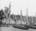
Houses and totem poles, Skidegate, 26 July 1878
-
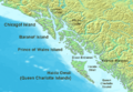
The northern Pacific Northwest Coast, showing the position of the archipelago in relation to other islands in the region.


See also
 In Spanish: Haida Gwaii para niños
- Council of the Haida Nation
- Dené–Yeniseian languages
- Guujaaw
- Haida Gwaii: On the Edge of the World
- Haida language
- Hlk'yah G̱awG̱a (Windy Bay)
- Indigenous peoples of Siberia
- Lohafex
- Lyell Island
- Moresby Camp
- List of islands of British Columbia
