
Langara Island facts for kids
|
Native name:
Ḵ'íis Gwáayaay
|
|
|---|---|
| Geography | |
| Coordinates | 54°14′03″N 133°01′13″W / 54.23417°N 133.02028°W |
| Archipelago | Haida Gwaii |
| Area | 8,080 acres (3,270 ha) |
| Administration | |
|
Canada
|
|
| Demographics | |
| Population | 460 |
Langara Island, known as Kiis Gwaii to the Haida people, is a special island in British Columbia, Canada. It is the northernmost island of the Haida Gwaii group. The island is about 8,080 acres (3,270 hectares) in size. It lies about 45 kilometers (28 miles) south of Alaska.
Contents
Island History
The island is named after Juan de Lángara. He was a Spanish naval commander. Spanish explorers mapped the coast of British Columbia. They named some places after him on their maps.
Juan José Pérez Hernández was the first European to see and record these islands. He sailed on a ship called the Santiago. Most of his crew were from Mexico. In July 1774, he met a group of Haida people near Langara Island.
In 1913, the Langara Light was built and lit. This important lighthouse stands at the northwest corner of the island.
Rat Eradication Project
Langara Island is one of the largest islands where Norway rats have been removed. A project to get rid of these rats started in July 1995. They used special bait to control the rat population. By May 1997, the island was declared free of rats. This was a big success for the island's wildlife.
Recent Events
On September 6, 2018, a fishing boat called the Haida Legend sank near Langara Island. The boat was fishing for halibut. The reason for the sinking is not known. Luckily, all the people on board were rescued safely.
Island Climate
Langara Island has an oceanic climate. This means it has cool to mild summers. The winters are very cool and rainy. Nights can be quite chilly.
| Climate data for Langara Island (1981-2010) | |||||||||||||
|---|---|---|---|---|---|---|---|---|---|---|---|---|---|
| Month | Jan | Feb | Mar | Apr | May | Jun | Jul | Aug | Sep | Oct | Nov | Dec | Year |
| Record high °C (°F) | 13.7 (56.7) |
12.8 (55.0) |
14.4 (57.9) |
19.4 (66.9) |
25 (77) |
25.6 (78.1) |
22.2 (72.0) |
25.4 (77.7) |
22.8 (73.0) |
20 (68) |
15 (59) |
12.8 (55.0) |
25.6 (78.1) |
| Mean daily maximum °C (°F) | 5.8 (42.4) |
6.0 (42.8) |
6.9 (44.4) |
8.9 (48.0) |
11.0 (51.8) |
13.2 (55.8) |
14.8 (58.6) |
15.8 (60.4) |
14.5 (58.1) |
11.2 (52.2) |
7.5 (45.5) |
6.1 (43.0) |
10.1 (50.2) |
| Daily mean °C (°F) | 4.0 (39.2) |
4.1 (39.4) |
4.8 (40.6) |
6.3 (43.3) |
8.5 (47.3) |
10.8 (51.4) |
12.7 (54.9) |
13.6 (56.5) |
12.3 (54.1) |
9.2 (48.6) |
5.6 (42.1) |
4.3 (39.7) |
8.0 (46.4) |
| Mean daily minimum °C (°F) | 2.2 (36.0) |
2.1 (35.8) |
2.5 (36.5) |
3.7 (38.7) |
6.0 (42.8) |
8.4 (47.1) |
10.6 (51.1) |
11.4 (52.5) |
10.0 (50.0) |
7.1 (44.8) |
3.7 (38.7) |
2.5 (36.5) |
5.9 (42.6) |
| Record low °C (°F) | −14.4 (6.1) |
−12 (10) |
−11.7 (10.9) |
−3.3 (26.1) |
0 (32) |
3.3 (37.9) |
5.6 (42.1) |
5.6 (42.1) |
1.1 (34.0) |
−4.5 (23.9) |
−15.9 (3.4) |
−12.8 (9.0) |
−15.9 (3.4) |
| Average precipitation mm (inches) | 205.8 (8.10) |
140.6 (5.54) |
149.8 (5.90) |
139.8 (5.50) |
109.3 (4.30) |
94.2 (3.71) |
93.5 (3.68) |
134.0 (5.28) |
190.5 (7.50) |
256.6 (10.10) |
230.0 (9.06) |
223.2 (8.79) |
1,967.2 (77.45) |
| Source: Environment Canada | |||||||||||||
Images for kids
-
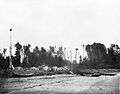
Dadens, Langara Island, 1878
.jpg)
See also
 In Spanish: Isla de Lángara para niños
