Hecate Strait facts for kids
Quick facts for kids Hecate Strait |
|
|---|---|
| French: Détroit d'Hécate | |

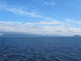
Hecate Strait and Pitt Island
|
|

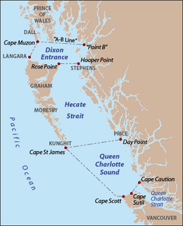
Hecate Strait as delineated by BCGNIS, along with Queen Charlotte Sound and Dixon Entrance. Red dots indicate capes and points, gray text indicates island names.
|
|
| Location | British Columbia, Canada |
| Coordinates | 53°11′N 130°50′W / 53.183°N 130.833°W |
| Native name | K̲andaliig̲wii Error {{native name checker}}: parameter value is malformed (help) |
| Ocean/sea sources | Pacific Ocean |
| Max. length | 260 km (160 mi) |
| Max. width | 140 km (87 mi) |
| Settlements | Queen Charlotte, Skidegate, Sandspit, Tlell, Kitkatla |
Hecate Strait is a wide but shallow body of water in British Columbia, Canada. It lies between the mainland of British Columbia and the Haida Gwaii islands (which used to be called the Queen Charlotte Islands). The Haida people call it K̲andaliig̲wii, or siigaay, which means "ocean".
This strait connects to Queen Charlotte Sound in the south and Dixon Entrance in the north. At its widest point in the south, Hecate Strait is about 140 kilometers (87 miles) across. It gets narrower in the north, shrinking to about 48 kilometers (30 miles) wide. The strait is about 260 kilometers (160 miles) long.
Contents
What is Hecate Strait?
The BCGNIS helps define the exact borders of Hecate Strait. Its southern edge is a line from the very bottom of Price Island to Cape St James. Cape St James is on Kunghit Island, which is the southernmost part of Haida Gwaii.
The northern edge of the strait runs from Rose Point. This point is the northeastern tip of Graham Island. The line then goes to Hooper Point, which is at the north end of Stephens Island, off the mainland.
History of Hecate Strait
Hecate Strait is known for its strong storms and rough weather. This is because it is quite shallow. The Haida knew how to navigate these tricky waters very well. They used the strait to travel to the mainland. They would visit coastal villages to trade or sometimes to take goods and captives.
Because the Haida understood the strait's currents and weather, other tribes from the mainland could not easily follow them. This made Hecate Strait a natural defense for the Haida people. It protected them from attacks.
The strait was named by Captain George Henry Richards in 1861 or 1862. He named it after his ship, the HMS Hecate, which he used for surveying the area.
Geology and the Ice Age
During the last Ice Age, this area looked very different. The seafloor of Hecate Strait was actually a wide coastal plain. This plain stretched south all the way to the Olympic Peninsula. It also included the area that is now Queen Charlotte Sound.
Animals and Plants in Hecate Strait
Hecate Strait was once a very important place for fishing. It had large numbers of salmon and halibut. These fish supported big fishing industries.
The strait is also home to a special type of animal called glass sponges. These sponges are very rare and are found in only a few places around the world. Because they are so unique and important, areas where these sponges live are now protected. This protection helps prevent damage from commercial fishing.
In February 2017, the Fisheries and Oceans Canada created the Hecate Strait and Queen Charlotte Sound Glass Sponge Reefs Marine Protected Area. This special protected area is located southeast of Haida Gwaii. It is also north and south of the entrance to the Douglas Channel.
The Marine Protected Area (MPA) is made up of three separate parts: the Northern Reef, the Central Reefs, and the Southern Reef. Together, these three areas cover about 2,410 square kilometers (930 square miles). The four main sponge reef groups in Hecate Strait and Queen Charlotte Sound are spread out over about 1,000 square kilometers (390 square miles). They are found in deep valleys, called glacial troughs, between 140 and 240 meters (460 and 790 feet) deep.
See also
 In Spanish: Estrecho de Hécate para niños
 | Dorothy Vaughan |
 | Charles Henry Turner |
 | Hildrus Poindexter |
 | Henry Cecil McBay |


