
Olympic Peninsula facts for kids
.jpg)


The Olympic Peninsula is a big piece of land in western Washington. It's located across Puget Sound from the city of Seattle. This amazing area is home to the famous Olympic National Park.
The peninsula has the Pacific Ocean to its west. To the north, you'll find the Strait of Juan de Fuca. On its east side is the Hood Canal. Two special points, Cape Alava and Cape Flattery, are also here. Cape Alava is the westernmost spot in the main United States. Cape Flattery is the northwesternmost point.
The Olympic Peninsula covers about 3,600 square miles (9,300 km²). For a long time, much of this area was unexplored. Most of its maps were made between 1898 and 1900 by Arthur Dodwell and Theodore Rixon. They mapped its land features and forests.
Contents
Geography
The Olympic Peninsula includes parts of several counties. These are Clallam and Jefferson Counties. It also covers the northern parts of Grays Harbor and Mason Counties. The Kitsap Peninsula is a different area. It is not connected to the Olympic Peninsula.
You can drive along the peninsula's eastern, northern, and western coasts. U.S. Route 101 runs through these areas. It starts near Olympia, which is the state capital.
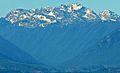
The Olympic mountain range is right in the middle of the peninsula. This mountain range is the second largest in Washington State. Its tallest peak is Mount Olympus.
There's a big effort called the Wild Olympics campaign. This group works to protect more wild areas on the peninsula. They also want to protect rivers where salmon live. They use a law called the Wild and Scenic River Act. This campaign also helps Olympic National Park buy land next to the park from people who want to sell it.
Climate

Most of the Olympic Peninsula has an oceanic climate. This means it has cool, wet winters and mild, dry summers. However, many towns and cities have a warm-summer Mediterranean climate. This climate has warm, dry summers and mild, wet winters.
The peninsula is famous for its temperate rain forests. These include the Hoh, Queets Rain Forest, and Quinault. These rainforests are mostly on the western side. The tall mountains in the middle create a "rain shadow" effect. This means areas to the northeast get much less rain and are drier.
Rivers
Many important rivers flow through the Olympic Peninsula. These rivers are home to salmon. Going clockwise from the southwest, some major rivers are:
- The Humptulips
- The Quinault
- The Queets
- The Quillayute
- The Bogachiel
- The Sol Duc
- The Lyre
- The Elwha (known for the Elwha Ecosystem Restoration project)
- The Dungeness
- The Dosewallips
- The Hamma Hamma
- The Skokomish
- The Wynoochee River
Lakes
The Olympic Peninsula has many beautiful natural lakes. These include:
There are also lakes formed by dams on rivers. These are called reservoirs.
Two other reservoirs, Lake Aldwell and Lake Mills, used to exist. They were created by dams on the Elwha River. But these dams were removed as part of the Elwha Ecosystem Restoration project.
Parks
The peninsula is home to many state and national parks. These parks protect the natural beauty and wildlife. Some of the state parks include:
- Anderson Lake
- Bogachiel
- Dosewallips
- Fort Flagler
- Fort Worden
- Lake Cushman
- Mystery Bay
- Old Fort Townsend
- Potlatch
- Sequim Bay
- Shine Tidelands
- Triton Cove
The famous Olympic National Park is also here. You can also find the Olympic National Forest. Inside the Olympic National Forest, there are five special wilderness areas. These are places where nature is left untouched. They include:
- The Brothers
- Buckhorn
- Colonel Bob
- Mt. Skokomish
- Wonder Mountain
Just off the west coast is the Washington Islands Wilderness.
Gallery
-
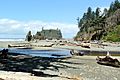
Cedar Creek and Abbey Island, Kalaloch Area
-
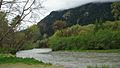
Hoh River
-
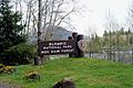
National Park Service Sign at the entrance of Hoh Rain Forest
-
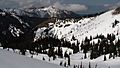
Hurricane Ridge
-
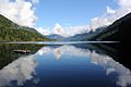
Lake Crescent
-
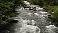
Elwha River
-
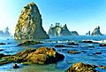
Point of the Arches
-
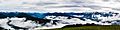
A foggy day at Hurricane Ridge
-
Mount Constance


Cities and towns in the Olympic Peninsula
Population of at least 10,000
Population of at least 5,000
Population of at least 1,000
Population of less than 1,000
See also
 In Spanish: Península Olímpica para niños
