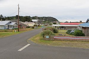
Pacific Beach, Washington facts for kids
Quick facts for kids
Pacific Beach, Washington
|
|
|---|---|

View of the community
|
|
| Country | United States |
| State | Washington |
| County | Grays Harbor |
| Area | |
| • Total | 1.23 sq mi (3.19 km2) |
| • Land | 1.21 sq mi (3.13 km2) |
| • Water | 0.03 sq mi (0.07 km2) |
| Elevation | 50 ft (20 m) |
| Population
(2020)
|
|
| • Total | 280 |
| • Density | 227/sq mi (87.8/km2) |
| Time zone | UTC-8 (Pacific (PST)) |
| • Summer (DST) | UTC-7 (PDT) |
| ZIP code |
98571
|
| Area code(s) | 360 |
| FIPS code | 53-52530 |
| GNIS feature ID | 1512546 |
Pacific Beach is a small community located in Grays Harbor County, Washington, United States. It is called a census-designated place (CDP). This means it's an area that the government counts for population, but it's not officially a city or town.
In 2020, about 280 people lived in Pacific Beach. This was a small decrease from 291 people counted in 2010. Before 2010, Pacific Beach was actually part of a larger area called Moclips.
Contents
Where is Pacific Beach Located?
Pacific Beach is found in the western part of Grays Harbor County. It sits right along the beautiful Pacific Ocean. To the north, it shares a border with Moclips. To the south, it is next to Joe Creek.
Exploring the Area Around Pacific Beach
The community also includes a small area called Highland Heights. This neighborhood is located just north of the main part of Pacific Beach.
A road called State Route 109 goes through Pacific Beach. If you travel north on this road, it's about 11 miles (18 km) to Taholah. If you go south, it's about 8 miles (13 km) to Copalis Beach. A larger city, Hoquiam, is about 25 miles (40 km) to the southeast.
How Big is Pacific Beach?
The total area of Pacific Beach is about 3.2 square kilometers (1.2 square miles). Most of this area is land. Only a small part, about 0.07 square kilometers (0.03 square miles), is water. This means about 2% of Pacific Beach is covered by water.
See Also
 In Spanish: Pacific Beach (Washington) for kids
 | John T. Biggers |
 | Thomas Blackshear |
 | Mark Bradford |
 | Beverly Buchanan |


