Taholah, Washington facts for kids
Quick facts for kids
Taholah, Washington
|
|
|---|---|

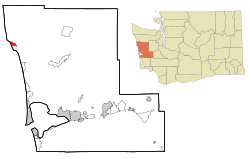
Location of Taholah, Washington
|
|
| Country | United States |
| State | Washington |
| County | Grays Harbor |
| Area | |
| • Total | 3.53 sq mi (9.13 km2) |
| • Land | 3.46 sq mi (8.96 km2) |
| • Water | 0.07 sq mi (0.18 km2) |
| Elevation | 7 ft (2 m) |
| Population
(2020)
|
|
| • Total | 776 |
| • Density | 220.13/sq mi (84.99/km2) |
| Time zone | UTC-8 (Pacific (PST)) |
| • Summer (DST) | UTC-7 (PDT) |
| ZIP code |
98587
|
| Area code(s) | 360 |
| FIPS code | 53-70175 |
| GNIS feature ID | 1531522 |
Taholah is a small village located on the Quinault Indian Reservation in Grays Harbor County, Washington, USA. It was named in 1905 after a Quinault chief. In 2020, about 776 people lived there.
Taholah is also a "census-designated place" (CDP). This means the US Census Bureau counts it as a specific area for statistics. The main office for the Quinault Indian Nation moved to Taholah from the town of Quinault.
Contents
History of Taholah Village
Taholah is in an area that could be affected by tsunamis. It also faces a risk of flooding from rising sea levels due to climate change. The village has a long wall, about 2,000 feet (610 meters) long, facing the Pacific Ocean. This wall, called a seawall, has needed many repairs because of damage.
Relocating the Village to Higher Ground
In 2015, the tribal government suggested a plan to move the village. This plan would cost about $60 million. The idea was to move the village to a higher area southeast of where it is now.
First, they needed to get 246 acres (100 hectares) of land. This land would be for 175 homes for 129 families from the current village. Then, new streets and water systems would be built.
By 2017, the estimated cost for the plan went up to $150 million. Construction started two years later in 2019. The first part of the new village opened in May 2021. It is a center for seniors and children called the Generations Building. In the Quinault language, this building is called WenɑsɡwəllɑʔɑW.
Geography of Taholah
Taholah is in the northwestern part of Grays Harbor County. The Quinault River flows into the Pacific Ocean right at the northern edge of Taholah.
Washington State Route 109 starts in Taholah. This highway goes south about 9 miles (14 km) to Moclips. It continues about 41 miles (66 km) to Hoquiam.
Land and Water Area
The Taholah census-designated place covers a total area of about 9.1 square kilometers (3.5 square miles). Most of this area, about 9.0 square kilometers (3.5 square miles), is land. The rest, about 0.2 square kilometers (0.1 square miles), is water.
Taholah's Climate
Taholah has a mild climate. This means there are only small differences between high and low temperatures. It also gets plenty of rain all year. According to the Köppen Climate Classification system, Taholah has a marine west coast climate. This type of climate is often called "Cfb" on climate maps. The average rainfall each year is 94 inches (239 cm).
Population and People
| Historical population | |||
|---|---|---|---|
| Census | Pop. | %± | |
| 2000 | 824 | — | |
| 2010 | 840 | 1.9% | |
| 2020 | 776 | −7.6% | |
In 2000, there were 824 people living in Taholah. Most of the people living there, about 93.20%, were Native American. About 4.85% were White.
The average household in Taholah had about 3.43 people. The average family had about 3.63 people. In 2000, about 38.1% of the population was under 18 years old. The median age was 28 years.
The Taholah School District's mascot is the Chitwhin. This word means "black bear" in the Quinault language.
See also
 In Spanish: Taholah (Washington) para niños
 | May Edward Chinn |
 | Rebecca Cole |
 | Alexa Canady |
 | Dorothy Lavinia Brown |

