
Discovery Bay, Washington facts for kids
Quick facts for kids
Discovery Bay, Washington
|
|
|---|---|

Discovery Bay as seen from Gardiner, Washington, with Diamond Point visible on the left
|
|
 |
|

Discovery Bay, Washington
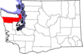
Location in Washington (state)

Discovery Bay, Washington
Location in the United States
|
|
| Country | United States |
| State | Washington |
| County | Jefferson |
| Time zone | UTC-8 (Pacific (PST)) |
| • Summer (DST) | UTC-7 (PDT) |
| Area code(s) | 360 |
Discovery Bay is a small community in Washington state. It's located in Jefferson County, right where two main roads, U.S. Route 101 and State Route 20, meet. This area sits at the very end of a body of water also called Discovery Bay.
The community is roughly halfway between the towns of Port Townsend and Sequim. Discovery Bay is a mix of homes and businesses. People here work in things like crabbing, oystering, and clamming. There's also timber work and gravel mining. You'll find a few restaurants and stores along US 101 that serve travelers.
Contents
What's in Discovery Bay?
The name "Discovery Bay" is now used for the whole area. But in the past, smaller communities here had different names. These names often came from the timber industry, which was very important long ago.
Old Community Names
- Fairmont is a group of homes on the southeast side of the bay. It's just off State Route 20.
- Discovery Junction was an old railroad crossing near Fairmont.
- Uncas was a mill town southwest of Fairmont, along US 101.
- Fort Discovery is where Captain Vancouver set up his camp long ago. Today, it's the home of Security Services NW.
- Maynard was another old mill town north of Uncas, also along US 101. You can still see parts of an old sawmill there. This mill was actually the Maynard Mill, not the older Port Discovery Mill.
These older names still appear on maps and in local road names. While these small towns aren't as busy as they once were, new homes and businesses are bringing fresh life to the area.
South Discovery Area
The larger area around Discovery Bay is sometimes called South Discovery. This includes places between Port Discovery and Port Townsend.
Nearby Places of Interest
Several other places are important to the history of Discovery Bay:
- Eaglemount is an area on the hills south of Discovery Bay. It's known for its high bluffs overlooking the bay.
- Port Discovery is where George Vancouver first visited Discovery Bay in 1792. Many people confuse it with the current Discovery Bay community. But Port Discovery was actually several miles north, at Mill Point, on the west side of the bay.
Other communities near Discovery Bay include:
- Port Townsend is about 5 miles (8 km) east of the bay. It was once a very important seaport.
- Cape George is on high bluffs at the bay's northeast entrance.
- Beckett Point is a shoreline community about a mile south.
- Adelma Beach is another shoreline community, about halfway down the bay.
- Gardiner is a community several miles west along US 101.
- Diamond Point is at the northwest entrance of the bay. It's across from Protection Island, which used to have a government quarantine station.
History of Discovery Bay
The land around the Strait of Juan de Fuca has been home to native people, like the Klallam (also called S'Klallam), for thousands of years. They lived in places all around Discovery Bay. Most native groups on the Olympic Peninsula were moved to reservations in the 1800s and early 1900s.
European Exploration
In 1792, explorer George Vancouver came to this area. He gave Discovery Bay and Port Discovery their names. His crew landed on the west shore of the bay to get fresh water. Today, a sign next to Highway 101 marks this important spot.
Early Mills and Towns
In 1858, a company from San Francisco started the Port Discovery Mill. It was located on the western shore of the bay, at a place now called Mill Point. Workers would cut down huge old trees from the hillsides. They would slide the logs down to the sawmill, where they were cut into lumber. This lumber was then loaded onto ships and sent to other ports.
A village grew up around the mill to house the workers. At its busiest, in the late 1800s, hundreds of people lived there. Port Discovery remained an important port for ships well into the 1900s.
Another big mill town was Maynard, located at the end of the bay. The Maynard mill operated until the 1970s. It was responsible for the growth of several smaller communities nearby. The old, abandoned sawmill was a popular sight for tourists and appeared in many old photos. Sadly, it was badly damaged by storms in 2005–2006. It was later removed to help restore the natural habitat.
Images for kids
-
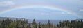
Discovery Bay as seen from Gardiner, Washington, with Diamond Point visible on the left
-
Map of Washington highlighting Jefferson County
See also
 In Spanish: Discovery Bay (Washington) para niños
