Port Ludlow, Washington facts for kids
Quick facts for kids
Port Ludlow, Washington
|
|
|---|---|

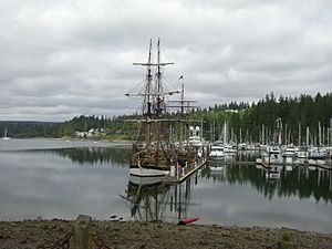
Port Ludlow marina
|
|

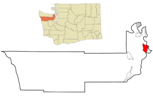
Location of Port Ludlow, Washington
|
|
| Country | United States |
| State | Washington |
| County | Jefferson |
| Area | |
| • Total | 14.1 sq mi (36.6 km2) |
| • Land | 11.5 sq mi (29.9 km2) |
| • Water | 2.6 sq mi (6.7 km2) |
| Elevation | 62 ft (19 m) |
| Population
(2021)
|
|
| • Total | 3,046 |
| • Density | 264.2/sq mi (102.0/km2) |
| Time zone | UTC-8 (Pacific (PST)) |
| • Summer (DST) | UTC-7 (PDT) |
| ZIP code |
98365
|
| Area code(s) | 360 |
| FIPS code | 53-55645 |
| GNIS feature ID | 1512578 |
Port Ludlow is a community in Jefferson County, Washington, in the United States. It is also the name of the bay where the community is located. The population of Port Ludlow was 2,603 in 2010, and it has grown since then.
Port Ludlow started as a place for logging and sawmills. Over time, it became a popular spot for resorts and planned communities. This happened after the Hood Canal Bridge was built in 1960. Many people who live here are retired or have vacation homes. It's also a great place for boats and sailing between Puget Sound and the San Juan Islands.
History of Port Ludlow
In 1841, an American exploration team led by Charles Wilkes explored Puget Sound. Wilkes gave many places American names. This was because the United States and Britain were still deciding who owned the land. Port Ludlow was named after Augustus Ludlow, an American naval hero from the War of 1812.
Early explorers often named sheltered bays "Port". So, Port Ludlow is both the name of the bay and the community next to it. Sometimes, people call the bay "Port Ludlow Bay" to avoid confusion.
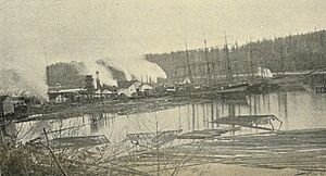
The first timber from Puget Sound was sent to San Francisco in 1851. This made people interested in building sawmills. In 1852, John R. Thorndike and W. P. Sayward came to Port Ludlow. They thought it was a good place for a mill. They built a mill that could produce a lot of lumber every day. Workers first cut down trees near the bay. Then, they used oxen and horses to bring logs from further away to the mill.
In 1860, Port Ludlow was one of the main areas counted in the U.S. Census for Jefferson County. The census showed that most of the 124 people living there were adults, mainly men. Many of these men worked as lumbermen or sawyers. Most people were born in the United States, but some came from countries like England, Ireland, and Canada.
Geography of Port Ludlow
The community of Port Ludlow is on the eastern side of Jefferson County. It sits on the northwest side of the Port Ludlow bay. The original part of the community is in the north. Newer areas have grown south of the bay.
Other small communities are also part of the Port Ludlow area. These include Mats Mats to the north, Swansonville to the northwest, and Beaver Valley to the west. Washington State Route 19 runs along the western edge of Port Ludlow. It connects to Port Hadlock to the north. Washington State Route 104 forms the southern edge. It crosses the Hood Canal to Port Gamble.
The total area of Port Ludlow is about 36.6 square kilometers (14.1 square miles). About 6.7 square kilometers (2.6 square miles) of this area is water.
Population of Port Ludlow
| Historical population | |||
|---|---|---|---|
| Census | Pop. | %± | |
| 2000 | 1,968 | — | |
| 2010 | 2,603 | 32.3% | |
| 2020 | 2,959 | 13.7% | |
| US Decennial Census 2020 Census |
|||
In 2000, there were 1,968 people living in Port Ludlow. Most people living here were White. A small number were Asian, Native American, or from other backgrounds.
Many households in Port Ludlow were married couples living together. A smaller number were individuals living alone. The average household had about two people.
The population of Port Ludlow tends to be older. In 2000, many residents were 45 years old or older. A large group was 65 years or older.
See also
 In Spanish: Port Ludlow (Washington) para niños
 | Leon Lynch |
 | Milton P. Webster |
 | Ferdinand Smith |


