San Juan Islands facts for kids
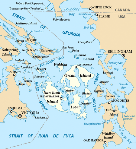
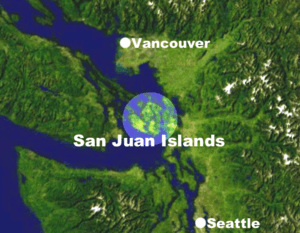
The San Juan Islands are a group of islands, also called an archipelago, located in the Pacific Northwest of the United States. They are found between the state of Washington and Vancouver Island in British Columbia, Canada. These islands are part of Washington state and make up most of San Juan County.
Four of the islands are easy to reach by car or on foot using the Washington State Ferries system.
Contents
Discovering the San Juan Islands
Long ago, the San Juan Islands were home to different groups of Coast Salish people. These groups included the Nooksack and Northern Straits people, who spoke different dialects like Lummi and Samish. Sadly, when Europeans arrived in the 1770s, they brought diseases like smallpox, which affected the native people.
Who Named the Islands?
The name "San Juan" was given to the islands by a Spanish explorer named Francisco de Eliza in 1791. He mapped the islands and called them Isla y Archiepelago de San Juan. He named many places after the Viceroy of Mexico, Juan Vicente de Güemes. This is why you find names like Orcas Island (short for "Horcasitas") and Guemes Island.
Later, in 1792, a British expedition led by George Vancouver also explored the area. He often kept the Spanish names that Eliza's team had already given. An American expedition led by Charles Wilkes explored in 1841. He sometimes gave new American names to places, like "Navy Archipelago" for the San Juan Islands. However, many of the original Spanish and British names were kept on the official maps later on.
The Pig War Dispute
In 1846, the Oregon Treaty set the border between Canada (which was British at the time) and the U.S. It said the border would follow the 49th parallel west to the middle of the Strait of Georgia. Then, it would go south through the main channel to the Strait of Juan de Fuca.
However, the treaty didn't clearly say which channel the border should follow between the Strait of Georgia and the Strait of Juan de Fuca. This led to a big argument about who owned the San Juan Islands! The U.S. said the border should be in Haro Strait, while Britain said it should be in Rosario Strait.
This argument became known as the Pig War in 1859. It started when an American farmer shot a pig belonging to the British Hudson's Bay Company. This small event almost led to a real war! Luckily, no one was hurt, and it became a long diplomatic talk.
Finally, in 1871, the issue was given to Emperor Wilhelm I of Germany to decide. In 1872, he decided that the border would go through Haro Strait, making the San Juan Islands part of the United States.
Nature and Wildlife
The San Juan Islands are full of amazing plants and animals!
Forests and Trees
In the past, many trees were cut down on the islands. But now, you can find lots of new forests with trees like coast Douglas fir, Pacific madrone, red alder, and bigleaf maple. There are also some rare, very old Douglas fir and western redcedar trees. In higher areas, you might see grand fir and western hemlock.
Birds of the Islands
The San Juan Islands are a special place for bald eagles, with more of them here than almost anywhere else in the U.S. You can also spot Great blue herons, black oystercatchers, and many other shorebirds. In winter, trumpeter swans and Canada geese visit. Look up for birds of prey like Peregrine falcons and barred owls.
Underwater, diving birds like rhinoceros auklets and pigeon guillemots swim in the seas. Recently, Western bluebirds, which had disappeared from the islands, were brought back thanks to volunteers!
Marine Animals
The islands are famous for their resident pods of orcas, also known as killer whales. These orcas mostly eat salmon. You might also see transient orcas that come to hunt harbor seals. Other marine mammals include river otters, Steller sea lions, and different types of whales and dolphins.
Land Animals
The largest land mammals on the San Juan Islands are Columbia black-tailed deer. Historically, there weren't many large predators here, except for wolves, which disappeared around the 1860s. There's also evidence that elk once lived on Orcas and Lopez Islands.
Before 1850, many freshwater areas on the islands were created by beaver dams. Beavers were hunted for their fur, but now they are starting to return to the islands. Their return helps create more habitats for birds, amphibians, and plants.
Northern sea otters were also hunted to extinction in Washington. However, some were brought back to the Washington coast in the 1960s and 1970s, and there have been sightings of them near the San Juan Islands.
Unfortunately, some non-native animals have also been introduced. In the 1890s, European rabbits were released and spread across the islands. They are sometimes hunted by red foxes, which are also not native to the islands.
Geography of the Islands
The United States Geological Survey (USGS) defines the San Juan Islands as the group of islands north of the Strait of Juan de Fuca, west of Rosario Strait, east of Haro Strait, and south of Boundary Pass. To the north is the open water of the Strait of Georgia. All these waters are part of the Salish Sea. The San Juan Islands are the same as San Juan County.
At high tide, there are over 400 islands and rocks in the archipelago, with 128 of them having names. The islands have more than 478 miles (769 km) of shoreline!
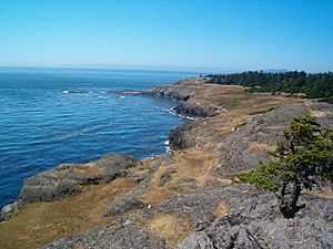
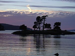
Most of the San Juan Islands are quite hilly, with some flat areas and fertile valleys. The highest point is Mount Constitution on Orcas Island, which is 2,407 feet (734 meters) tall. The coastlines have sandy and rocky beaches, quiet coves, and deep harbors. You'll see beautiful, twisted madrona trees along the shores and evergreen fir and pine forests inland.
The San Juan Islands get less rain than Seattle, which is about 65 miles (105 km) south. This is because they are in the rain shadow of the Olympic Mountains. Summers are warm, around 70°F (21°C), and winters are mild, usually in the high 30s and low 40s Fahrenheit (around 5°C). Snow is rare, but strong winds can occur.
Visiting the Islands Today
Today, the San Juan Islands are a very popular place for tourists. Many people come for sea kayaking and orca whale-watching tours by boat or air. Lime Kiln Point State Park on San Juan Island is a great spot to watch whales from shore, and there are often experts there to tell you about them.
The islands are also home to the San Juan Islands National Monument, which protects 75 different areas.
Getting to the San Juan Islands
There are no bridges connecting the San Juan Islands to the mainland. So, you can only get there by water or by air!
By Water
Several ferry systems serve some of the San Juan Islands:
- Washington State Ferries takes you to Lopez Island, Shaw Island, Orcas Island, and San Juan Island from Anacortes, Washington, and Sidney, British Columbia.
- Puget Sound Express offers passenger-only service from Port Townsend to Friday Harbor on San Juan Island.
- Clipper Navigation's Victoria Clipper has seasonal ferry service to Friday Harbor from Vancouver Island and Seattle.
There are also private passenger-only ferries that serve more islands, usually during certain seasons.
By Air
You can also fly to the San Juan Islands:
- Kenmore Air flies to and from Roche Harbor, Orcas Island, and Seattle.
- San Juan Airlines flies to and from Anacortes, Bellingham, Eastsound (Orcas Island), Lopez Island, and other smaller islands. They also connect to Seattle.
Shipping Routes
The San Juan Islands are surrounded by important shipping channels. Haro Strait and Boundary Pass are the busiest routes for ships connecting the Strait of Juan de Fuca and the Strait of Georgia. This is the main way ships travel between the Port of Vancouver and the Pacific Ocean.
Rosario Strait is also a major shipping channel. Many oil tankers use this strait each year to reach refineries near Anacortes.
List of Islands
This list includes islands that are part of San Juan County, as defined by the USGS. The estimated populations for inhabited islands in 2016 are in parentheses, but these numbers can change a lot during different seasons. Islands that are protected as state parks are marked with an asterisk (*).
- Aleck Rocks
- Alegria Island (aka Little Double Island)
- Armitage Island
- Bare Island
- Barnes Island
- Barren Island
- Battleship Island
- Bell Island
- Big Rock
- Bird Rock
- Bird Rocks
- Black Rock
- Blakely Island (42)
- Blind Island (Lopez)
- Blind Island *Boulder Island
- Brown Island (21)
- Buck Island
- Cactus Islands
- Canoe Island
- Castle Island
- Cayou Island (aka Rum Island)
- Cemetery Island
- Center Island (20)
- Charles Island
- Clark Island *Cliff Island
- Cluster Islands
- Colville Island
- Coon Island
- Crab Island
- Crane Island (10)
- Deadman Island
- Decatur Island (89)
- Dinner Island
- Doe Island *Double Island
- Ewing Island
- Fawn Island
- Flattop Island
- Flower Island
- Fortress Island
- Freeman Island
- Frost Island
- Geese Islets
- Giffin Rocks
- Goose Island
- Gossip Island
- Gull Rock
- Guss Island
- Hall Island
- Harnden Island
- Henry Island (27)
- Iceberg Island
- Iowa Rock
- James Island *Johns Island (5)
- Jones Island *Justice Island
- Little Patos Island
- Little Sister Island
- Little Sucia Island
- Lone Tree Island
- Long Island
- Lopez Island (2,466)
- Low Island
- Matia Island *McConnell Island
- Mummy Rocks
- Nob Island
- North Finger Island
- North Peapod Island
- O'Neal Island
- Oak Island
- Obstruction Island (14)
- Orcas Island (5,395)
- Patos Island *Peapod Rocks
- Pearl Island (11)
- Picnic Island (aka Sheep Island)
- Pointer Island
- Pole Island
- Posey Island *Puffin Island
- Ram Island
- Reads Bay Island
- Reef Island
- Reef Point Island
- Richardson Rock
- Rim Island
- Ripple Island
- Saddlebag Island *San Juan Island (7,810)
- Satellite Island
- Secar Rock
- Sentinel Island
- Shag Rock
- Shaw Island (241)
- Skipjack Island
- Skull Island (Lopez)
- Skull Island
- Small Island
- South Finger Island
- South Peapod Island
- Spieden Island
- Stuart Island (11) *Sucia Island (4) *Swirl Island
- The Sisters
- Tift Rocks
- Trump Island
- Turn Island *Twin Rocks
- Vendovi Island
- Victim Island
- Waldron Island (109)
- Wasp Islands
- Whale Rocks
- White Rocks
- Willow Island
- Yellow Island
See also
 In Spanish: Islas San Juan para niños
 | Jewel Prestage |
 | Ella Baker |
 | Fannie Lou Hamer |


