Boundary Pass facts for kids
Quick facts for kids Boundary Pass |
|
|---|---|
| French: Passe Frontière | |

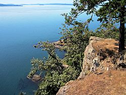
View of Boundary Pass from Monarch Head, Saturna Island
|
|

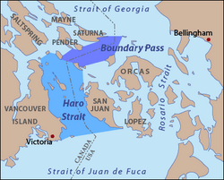
Map of Boundary Pass and Haro Strait according to USGS definitions
|
|
| Location | British Columbia and Washington |
| Coordinates | 48°43′00″N 123°08′00″W / 48.71667°N 123.13333°W |
| Type | Strait |
| Part of | Salish Sea |
| Basin countries | Canada and United States |
| Max. length | 23 km (14 mi) |
Boundary Pass is a narrow stretch of water, called a strait. It runs for about 23 kilometers (14 miles). This strait forms part of the border between two countries. These are Canada (specifically, the province of British Columbia) and the United States (the state of Washington).
Boundary Pass is an important waterway. It connects two larger bodies of water. To the south, it links up with the Haro Strait. To the north, it leads into the Strait of Georgia. Both of these are part of the larger Salish Sea.
Where is Boundary Pass?
Boundary Pass is located in a beautiful area with many islands. It acts like a natural dividing line. This line separates some of the islands belonging to Canada from those belonging to the United States.
Defining the Edges
The USGS helps define the exact boundaries of this strait. Imagine lines drawn between different points on nearby islands. For example, the northern edge of Boundary Pass runs from East Point on Saturna Island (Canada) to Alden Point on Patos Island (U.S.).
Other lines connect points on islands like Waldron Island, Stuart Island, Moresby Island, and Pender Island. These lines help map out the precise shape of Boundary Pass. They show where the international border crosses through the water.
Connecting Important Waters
Boundary Pass is a key part of the Salish Sea. This is a large network of coastal waterways. It includes many straits, inlets, and sounds. The Salish Sea is shared by both Canada and the United States.
The strait helps ships and boats travel between the Haro Strait and the Strait of Georgia. These waters are busy with ferries, cargo ships, and recreational boats. They all use these passages to move between different areas.
 | Bessie Coleman |
 | Spann Watson |
 | Jill E. Brown |
 | Sherman W. White |


