Saturna Island facts for kids
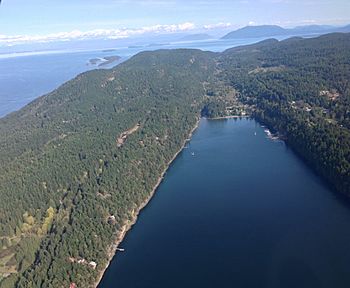
South-facing aerial view of Saturna Island
|
|
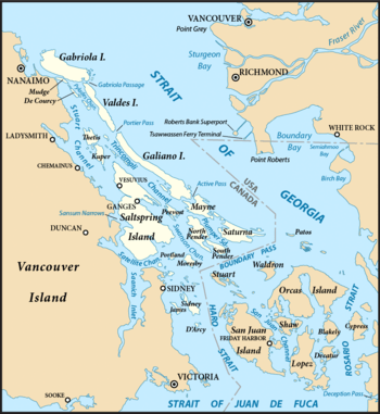
The Southern Gulf Islands, including Saturna
|
|
| Geography | |
|---|---|
| Coordinates | Lua error in Module:Coordinates at line 614: attempt to index field 'wikibase' (a nil value). |
| Archipelago | Gulf Islands |
| Adjacent bodies of water | Strait of Georgia, Boundary Pass |
| Area | 31 km2 (12 sq mi) |
| Highest elevation | 397 m (1,302 ft) |
| Administration | |
|
Canada
|
|
| Province | British Columbia |
| Regional District | Capital Regional District |
| Demographics | |
| Population | 350 |
Saturna Island is a beautiful, mountainous island in British Columbia, Canada. It is part of the Southern Gulf Islands chain. The island is about 31 square kilometers (12 square miles) in size.
Saturna Island is located between the Lower Mainland of B.C. and Vancouver Island. It is the most easterly of the Gulf Islands. The island is very close to the Canada–United States border. To the north, you can see Point Roberts, Washington. To the east and south, you'll find the San Juan Islands.
A special area on the island is a First Nations reserve. This land belongs to the Tsayout and Tseycum Nations. About 350 people live on Saturna Island all year round. However, many more visitors come to the island during the summer months.
About half of Saturna Island is part of the Gulf Islands National Park Reserve (GINPR). This park was created in 2003. It includes land given by Ulla Ressner and John Fry, along with existing provincial parks and other public lands.
Contents
Discovering Saturna Island's Past
Saturna Island has a long and interesting history. The first people to live here were indigenous groups. They called the island "Long Nose." This name came from the island's shape, which has a long, narrow shoreline ending at East Point.
The name "Saturna" comes from a Spanish ship. In 1791, a Spanish naval schooner named Santa Saturnina explored the island's coast. The ship's pilot, José María Narváez, led this exploration. The name was first used for East Point. Later, in 1792, Dionisio Alcalá Galiano shortened it to "Saturna" for the whole island.
European settlers started arriving in the 1800s. However, Saturna Island grew slower than other nearby islands. This was because it was quite isolated and had many mountains.
Fun Things to Do on Saturna Island
Saturna Island offers many exciting activities for visitors.
Whale Watching at East Point
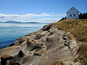
East Point is a very popular spot for watching whales from the shore. It's a great place to see these amazing creatures. The Saturna Island Heritage Committee runs a small museum here. It's located in the old fog alarm building. You can learn about Saturna's history and the story of Moby Doll. Moby Doll was the second orca ever held in captivity, captured near here in 1964.
Spotting Orcas and Wildlife
The southern resident J, K, and L orca pods often swim past Saturna in the summer. You might also see Bigg's orcas (also called transient orcas) throughout the year. Saturna is home to many different animals. You can find animals on land, in the air, and in the water.
Geocaching Adventures
Saturna is a fantastic place for geocaching. There are about 60 geocaches hidden around the island. Parks Canada and the Saturna Ecological Education Centre create and look after these caches.
Canada Day Lamb Barbeque
Every year on Canada Day (July 1st), Saturna Island hosts a special event. It's called the Saturna Island Lamb Barbeque. This tradition has been going on since 1950. Part of the money raised goes to the Saturna Community Club.
Exploring Parks and Beaches
Saturna Island has beautiful parks and beaches to explore.
East Point Day Use Area
The East Point Day Use Area is a great place to visit. It has a museum inside the old Fog Alarm Building. There's also an Environment Canada monitoring station. You can enjoy the unique sandstone shoreline here.
Lyall Creek Trail
The Lyall Creek trail is about 1 kilometer (0.6 miles) long. It winds through a second-growth forest. This trail follows one of the few salmon-bearing creeks in the Southern Gulf Islands. It leads hikers to Narvaez Bay Road.
Mount Warburton Pike Viewpoint
Mount Warburton Pike is the tallest mountain in the Outer Gulf Islands. From its peak, you can enjoy amazing views. There is also a communication tower on top, used for radio and television services.
Winter Cove Day Use Area
At the westernmost part of the island is Winter Cove Day Use Area. This area has different ecosystems, including wetlands and marshes. Strong tidal currents flow through Boat Pass here. This pass offers a shortcut for small boats.
Local Parks and Beaches
Besides the Gulf Islands National Park Reserve, Saturna Island has many public beach access points. These are marked around the island. The Thomson Community Park is also managed by the local Parks & Recreation Commission. It features a pebble beach, a picnic shelter, and a nine-hole disc golf course.
Camping on Saturna Island
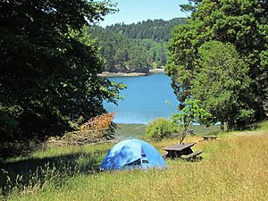
The Gulf Islands National Park Reserve offers 7 backcountry campsites at Narvaez Bay. You can reach these sites by walking or kayaking. The trail to Narvaez Bay starts at the parking lot at the end of Narvaez Bay Road. There's also a bike rack for cyclists.
From the parking lot, a 1-kilometer (0.6-mile) trail leads to two beaches: Narvaez Bay and Echo Bay. A side trail goes to Monarch Head, which offers views of Boundary Pass and the San Juan Islands. Please note that there is no drinking water at Narvaez Bay. Campfires are not allowed, no matter the season.
Two private campgrounds on the island offer camping all year round. They also do not allow fires, but they do provide access to drinking water.
Climate
| Climate data for Saturna Island | |||||||||||||
|---|---|---|---|---|---|---|---|---|---|---|---|---|---|
| Month | Jan | Feb | Mar | Apr | May | Jun | Jul | Aug | Sep | Oct | Nov | Dec | Year |
| Record high °C (°F) | 13.0 (55.4) |
15.0 (59.0) |
21.0 (69.8) |
23.0 (73.4) |
28.0 (82.4) |
30.5 (86.9) |
33.0 (91.4) |
31.5 (88.7) |
28.5 (83.3) |
23.0 (73.4) |
15.0 (59.0) |
13.5 (56.3) |
33.0 (91.4) |
| Mean daily maximum °C (°F) | 6.3 (43.3) |
7.4 (45.3) |
9.5 (49.1) |
12.4 (54.3) |
15.7 (60.3) |
18.4 (65.1) |
21.3 (70.3) |
21.4 (70.5) |
18.7 (65.7) |
12.8 (55.0) |
8.4 (47.1) |
6.2 (43.2) |
13.2 (55.8) |
| Daily mean °C (°F) | 4.3 (39.7) |
5.0 (41.0) |
6.6 (43.9) |
9.1 (48.4) |
12.0 (53.6) |
14.5 (58.1) |
17.1 (62.8) |
17.3 (63.1) |
15.1 (59.2) |
10.2 (50.4) |
6.4 (43.5) |
4.3 (39.7) |
10.2 (50.4) |
| Mean daily minimum °C (°F) | 2.3 (36.1) |
2.5 (36.5) |
3.7 (38.7) |
5.7 (42.3) |
8.3 (46.9) |
10.6 (51.1) |
12.8 (55.0) |
13.2 (55.8) |
11.4 (52.5) |
7.6 (45.7) |
4.2 (39.6) |
2.4 (36.3) |
7.1 (44.7) |
| Record low °C (°F) | −10.0 (14.0) |
−8.0 (17.6) |
−6.0 (21.2) |
0.0 (32.0) |
1.0 (33.8) |
5.0 (41.0) |
8.0 (46.4) |
9.0 (48.2) |
5.0 (41.0) |
−1.5 (29.3) |
−9.0 (15.8) |
−12.5 (9.5) |
−12.5 (9.5) |
| Average precipitation mm (inches) | 129.0 (5.08) |
64.6 (2.54) |
65.0 (2.56) |
52.7 (2.07) |
43.4 (1.71) |
37.3 (1.47) |
21.3 (0.84) |
32.9 (1.30) |
29.6 (1.17) |
90.2 (3.55) |
140.1 (5.52) |
106.2 (4.18) |
812.3 (31.99) |
| Average rainfall mm (inches) | 115.4 (4.54) |
59.6 (2.35) |
57.7 (2.27) |
52.7 (2.07) |
43.4 (1.71) |
37.3 (1.47) |
21.3 (0.84) |
32.9 (1.30) |
29.6 (1.17) |
89.7 (3.53) |
134.4 (5.29) |
98.2 (3.87) |
772.2 (30.41) |
| Average snowfall cm (inches) | 13.9 (5.5) |
5.0 (2.0) |
6.7 (2.6) |
0 (0) |
0 (0) |
0 (0) |
0 (0) |
0 (0) |
0 (0) |
0.5 (0.2) |
5.7 (2.2) |
7.9 (3.1) |
39.7 (15.6) |
| Average precipitation days (≥ 0.2 mm) | 20.3 | 14.8 | 17.1 | 15.2 | 12.4 | 10.5 | 5.9 | 6.8 | 7.4 | 16.3 | 20.9 | 19.8 | 167.4 |
| Average rainy days | 18.6 | 13.9 | 16.7 | 15.2 | 12.4 | 10.5 | 5.9 | 6.8 | 7.4 | 16.2 | 20.5 | 18.5 | 162.6 |
| Average snowy days (≥ 0.2 cm) | 2.6 | 1.4 | 1.1 | 0 | 0 | 0 | 0 | 0 | 0 | 0.1 | 0.7 | 1.9 | 7.8 |
| Source: Environment Canada | |||||||||||||
Saturna Island has a mild climate, typical of the Pacific Northwest. Summers are generally warm and dry, while winters are cool and wet. The weather box above shows detailed climate information for the island.
Getting to Saturna Island
There are several ways to reach Saturna Island.
Ferry Services
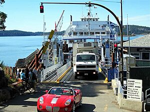
You can take a BC Ferries boat to Lyall Harbour on Saturna. Daily sailings are available from Swartz Bay on Vancouver Island. You can also come from Tsawwassen on the Mainland.
Floatplane Travel
Daily floatplane service is also available. You can fly from Vancouver International Airport. Flights also depart from downtown Victoria to Lyall Harbour.
Private Boats
If you have your own boat, Saturna Island has many great places to anchor. Lyall Harbour Government Wharf is a good option. It is managed by the Capital Regional District's Harbour Commission.
See also
 In Spanish: Isla Saturna para niños
 | Emma Amos |
 | Edward Mitchell Bannister |
 | Larry D. Alexander |
 | Ernie Barnes |


