Capital Regional District facts for kids
Quick facts for kids
Capital
|
||
|---|---|---|
|
Regional district
|
||
| Capital Regional District | ||
|
||
| Nickname(s):
CRD
|
||
| Motto(s):
Making a difference...together
|
||

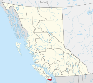
Location in British Columbia
|
||
| Country | Canada | |
| Province | British Columbia | |
| Incorporated | 1966 | |
| Administrative office location | Victoria | |
| Government | ||
| • Body | Board of directors | |
| Area | ||
| • Total | 2,340.49 km2 (903.67 sq mi) | |
| Population
(2021)
|
||
| • Total | 415,451 | |
| • Density | 177.7/km2 (460/sq mi) | |
| Time zone | UTC-8 (PST) | |
| • Summer (DST) | UTC-7 (PDT) | |
| Area codes | 250 / 778 / 236 / 672 | |
The Capital Regional District (CRD) is like a local government for the southern part of Vancouver Island and the southern Gulf Islands in British Columbia, Canada. It is one of several regional districts in British Columbia. In 2021, about 415,451 people lived here.
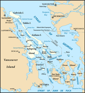
The CRD includes thirteen cities and towns around Greater Victoria. It also covers three areas that are not part of any city: Juan de Fuca, Salt Spring Island, and Southern Gulf Islands. The CRD acts as the local government for these non-city areas. The main office of the CRD is in Victoria. The total land area of the CRD is about 2,341 square kilometers.
The CRD was created in 1966. Its goal was to help coordinate important issues for the whole region. It also provides local government services to the rural areas.
Contents
People and Population
The Capital Regional District is a growing area. In 2021, the population was 415,451 people. This was a good increase from 383,360 people in 2016. The CRD covers about 2,338 square kilometers of land. This means there are about 177.7 people living in each square kilometer.
Different Backgrounds of People
Most people in the Capital Regional District are of European background. However, many other groups live here too, making it a diverse place. Here's a look at the different backgrounds as of 2021:
- European: About 78.85% of the population.
- East Asian: About 5.77% of the population.
- Indigenous (First Nations): About 4.97% of the population.
- South Asian: About 3.40% of the population.
- Southeast Asian: About 3.08% of the population.
- African: About 1.27% of the population.
- Latin American: About 0.99% of the population.
- Middle Eastern: About 0.87% of the population.
- Other: About 0.79% of the population.
Some people might have more than one background, so the percentages can add up to more than 100%.
The number of people from visible minority groups in the CRD is lower than in other parts of British Columbia. In 2021, about 16.7% of people in Greater Victoria identified as visible minorities. This is less than the 34.4% for all of British Columbia. The largest visible minority groups in the CRD are Chinese (4.5%), South Asian (3.5%), and Filipino (2.2%).
How the Region is Organized
The CRD includes 13 cities and towns, three special "electoral areas," and 10 Indigenous reserves. The CRD government does not have power over the Indigenous reserves.
The cities of Saanich and Victoria together have more than half of the CRD's total population.
| Area Name | Type of Area | Population (2021) |
Population (2016) |
Change (2016-2021) |
|---|---|---|---|---|
| Saanich | District municipality | 117,735 | 114,148 | 3.1% |
| Victoria | City | 91,867 | 85,792 | 7.1% |
| Langford | City | 46,584 | 35,342 | 31.8% |
| Oak Bay | District municipality | 17,990 | 18,094 | -0.6% |
| Esquimalt | Town | 17,533 | 17,655 | -0.7% |
| Colwood | City | 18,961 | 16,859 | 12.5% |
| Central Saanich | District municipality | 17,385 | 16,814 | 3.4% |
| Sooke | District municipality | 15,086 | 13,001 | 16.0% |
| Sidney | Town | 12,318 | 11,672 | 5.5% |
| North Saanich | District municipality | 12,235 | 11,249 | 8.8% |
| View Royal | Town | 11,575 | 10,408 | 11.2% |
| Metchosin | District municipality | 5,067 | 4,708 | 7.6% |
| Highlands | District municipality | 2,482 | 2,225 | 11.6% |
| Salt Spring Island | Regional district electoral area | 11,635 | 10,557 | 10.2% |
| Juan de Fuca | Regional district electoral area | 5,531 | 4,860 | 13.8% |
| Southern Gulf Islands | Regional district electoral area | 6,101 | 4,732 | 28.9% |
| Total Capital Regional District | 415,451 | 383,360 | 8.4% | |
Electoral Areas: Special Regions
Electoral Areas are parts of the CRD that are not organized as cities or towns. They have their own director who represents them on the CRD board.
Salt Spring Island Electoral Area
This area covers the parts of Salt Spring Island that are not part of a city. It has one director on the CRD board.
Some of the main places in this area are:
- Ganges
- Fulford Harbour
- Vesuvius Bay
- Long Harbour
- Beaver Point
- Musgrave Landing
In 2021, the population of Salt Spring Island Electoral Area was 11,635 people. The area is about 182.23 square kilometers.
Southern Gulf Islands Electoral Area

This area includes parts of Galiano, Saturna, Mayne, and North and South Pender Islands. It also covers many smaller islands in the Gulf of Georgia. This area used to be called the Outer Gulf Islands Electoral Area. Its population of 6,101 people is represented by one director on the CRD board.
Some of the main places in this area are:
- Bedwell Harbour (on South Pender Island)
- Montague Harbour (on Galiano Island)
- Otter Bay (on North Pender Island)
- Saturna (on Saturna Island)
- Sturdies Bay (on Galiano Island)
- Village Bay (on Mayne Island)
Juan de Fuca Electoral Area
The Juan de Fuca Electoral Area covers the parts of Vancouver Island within the CRD that are not cities. This includes areas like Willis Point (Greater Victoria), Malahat, East Sooke, Jordan River, Otter Point, Shirley, and Port Renfrew. It also includes some First Nations reserves.
The population of this area is 5,531 people. It is represented by one director on the CRD board. The total land area is about 1,502.24 square kilometers.
What the CRD Does
The CRD has a board of directors. These directors are either elected by people in the electoral areas or chosen from the elected officials in the cities and towns.
The CRD is responsible for many important services in the region, such as:
- Recycling programs.
- Running the regional landfill (where garbage goes).
- Building and operating sewage treatment plants.
- Managing the regional water supply.
- Helping to fund local arts groups.
- Planning for the region's future growth.
- Funding health facilities.
- Taking care of over thirty regional parks, trails, and park reserves. These parks cover more than 100 square kilometers!
The CRD also owns and manages over 1,200 rental homes through the Capital Region Housing Corporation. In some areas, the CRD can make rules (called bylaws) that everyone must follow. For example, there is a "clean air bylaw" that bans smoking in all public places and restaurant patios.
In the electoral areas (the parts not in cities), the CRD provides services that cities usually handle. These include animal control, building inspections, fire protection, and making sure bylaws are followed. Some cities also pay the CRD to provide some of these services for them.
Capital Regional Hospital District
The Capital Regional Hospital District (CRHD) is closely linked to the CRD. Its main job is to help pay for new hospitals and medical equipment in the region. The actual healthcare services are provided by the Vancouver Island Health Authority (VIHA). The CRHD has the same board of directors as the CRD.
Related Places
- Metro Vancouver Regional District
- Greater Victoria
- Gulf Islands
See also
 In Spanish: Distrito regional de la Capital para niños
 | Precious Adams |
 | Lauren Anderson |
 | Janet Collins |

