Gulf Islands facts for kids
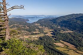
View from Baynes Peak on Salt Spring Island
|
|
| Geography | |
|---|---|
| Location | Salish Sea |
| Coordinates | 48°57′N 123°32′W / 48.950°N 123.533°W |
| Major islands | 20 |
| Administration | |
| Province | British Columbia |
| Demographics | |
| Population | 23,497 (2016 est.) |
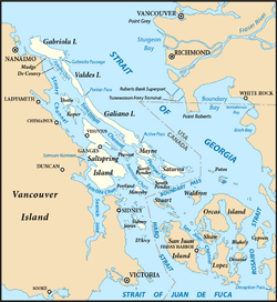
The Gulf Islands are a beautiful group of islands in British Columbia, Canada. They are found in the Salish Sea, a large body of water between Vancouver Island and the mainland coast. These islands are known for their stunning natural beauty and unique ecosystems.
Contents
Understanding the Name "Gulf Islands"
The name "Gulf Islands" comes from "Gulf of Georgia." This was the original name given by George Vancouver when he mapped the southern islands. The "Gulf" refers to all the waters around these islands. This includes places like Active Pass and Trincomali Channel.
In 2010, the larger area including the Strait of Georgia, the Strait of Juan de Fuca, and Puget Sound was officially named the Salish Sea. This new name helps describe the entire connected water system.
Where Are the Gulf Islands?
The name "Gulf Islands" first referred to the islands at the southern end of the Strait of Georgia. These included islands from Gabriola Island in the north to Saturna Island in the southeast.
Over time, the name started to include all the islands in the Strait of Georgia. This led to new terms like "Southern Gulf Islands" and "Northern Gulf Islands." For example, Quadra Island is now often called the northernmost of the Gulf Islands.
Exploring the Island Groups
The Gulf Islands are usually divided into two main groups: the Southern and Northern Gulf Islands. The city of Nanaimo on Vancouver Island helps mark the dividing line between them. Islands like those in the Discovery Islands or Howe Sound are not part of the Gulf Islands.
Southern Gulf Islands
The Southern Gulf Islands are located at the southern end of the Strait of Georgia. They form a complex network of waterways within the Salish Sea. This group includes hundreds of islands and small islets. They are part of a larger group of islands that also includes the San Juan Islands in the United States.
Here are some of the major Southern Gulf Islands:
| Island | Regional district | Area (km2) | Population | Density (per km2) |
|---|---|---|---|---|
| Gabriola | Nanaimo | 57.6 | 4,000 | 69.4 |
| Galiano | Capital | 60.15 | 1,044 | 17.4 |
| Mayne | Capital | 21 | 1,071 | 51 |
| Moresby | Capital | 8.34 | 3 | 0.4 |
| Pender | Capital | 34 | 2,245 | 66.0 |
| Penelakut | Cowichan Valley | 8.66 | 302 | 34.9 |
| Prevost | Capital | 6.75 | ? | ? |
| Salt Spring | Capital | 182.7 | 10,557 | 57.8 |
| Saturna | Capital | 31 | 350 | 11.3 |
| Sidney | Capital | 8.66 | ? | ? |
| Thetis | Cowichan Valley | 10.36 | 350 | 33.8 |
| Valdes | Cowichan Valley | 9 | ? | ? |
Northern Gulf Islands
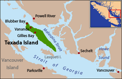
The Northern Gulf Islands are found near the northern end of the Strait of Georgia. This group includes all islands south of Savary Island. Savary Island is the southernmost island of the nearby Discovery Islands.
Here are some of the major Northern Gulf Islands:
| Island | Regional district | Area (km2) | Population | Density (per km2) |
|---|---|---|---|---|
| Ahgykson | qathet | 9.25 | 0 | 0 |
| Denman | Comox Valley | 51.03 | 1,165 | 22.8 |
| Hardy | Sunshine Coast | 7.25 | ? | ? |
| Hornby | Comox Valley | 29.97 | 958 | 32.0 |
| Lasqueti | qathet | 73.32 | 399 | 5.4 |
| Nelson | Sunshine Coast | 102.8 | ? | ? |
| Texada | qathet | 300.45 | 1,053 | 3.5 |
| Thormanby | Sunshine Coast | 8.65 | ? | ? |
Nature and Wildlife
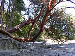
The Gulf Islands and the waters around them are full of diverse plants and sea life. You can find beautiful Arbutus trees, wild lilies, and large kelp beds. Many marine animals live here, including amazing Orcas.
The Garry Oak Ecosystem
The Gulf Islands are home to some of the last remaining Garry oak ecosystems. These special ecosystems are very rare. Only about five percent of them are left in their natural state. This means that 91 of the 350 species that live there are at risk.
The islands have a unique Mediterranean-like climate. This climate helps the Garry oak ecosystem to thrive. Garry oak ecosystems have more plant species than any other natural area on the coast of British Columbia. They are one of Canada's most endangered natural habitats.
Today, Garry oak meadows are found in shallow soil in valleys and on rocky foothills. They are also on southern slopes. These were areas that people in the past 150 years did not use for farming or building.
Protecting Nature
The Garry Oak Ecosystems Recovery Team (GOERT) was created in 1999. This group works to protect and restore the rare Garry oak ecosystem. They encourage both public and private efforts to save this important habitat.
The unique nature of the islands has been a focus for conservation for many years. BC Parks manages several provincial parks on the islands. The oldest is Mount Maxwell Provincial Park on Salt Spring Island.
In 2003, Parks Canada created the Gulf Islands National Park Reserve. This park helps protect important natural areas in the southeastern Gulf Islands. The goal is to protect most of these islands in the long term.
Parks Canada also looked into creating a National Marine Conservation Area in 2012. This area would protect important marine habitats. It would also make sure that marine resources are used in a way that can last. This would work together with the existing national park.
Farming and Food
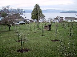
Most parts of Canada are too cold for olive trees to grow well. However, Pender Island, Saturna Island, and Salt Spring Island have a Mediterranean-style climate. This climate allows olive trees to grow and produce olives.
One of the first people to bring olive trees to the Southern Gulf Islands was Banana Joe Clemente in 1993. He grew many trees from seeds. He even planted an olive grove on Salt Spring Island. He also shared olive trees with other islanders.
Andrew Butt started his olive farm on Pender Island in 2001. He used special types of olives called Frantoio and Leccino cultivars from California. He uses kelp from the ocean as fertilizer. He also prunes his trees to help them get more sunlight. In 2009, Michael Pierce started a plant nursery on Saturna Island that supplied olive trees to the region.
Getting Around the Islands
The larger islands with people living on them are served by BC Ferries. These ferries carry both vehicles and passengers. They travel between the Gulf Islands and to major cities like Nanaimo and Victoria on Vancouver Island. They also go to Vancouver on the mainland.
None of the islands are connected to each other by bridges. The only exception is Pender Island, which was split into two by a canal in 1903. There have been ideas to build bridges, but they haven't happened. This is because building bridges would be very expensive. Also, the islands have sensitive natural areas and mountains. Many locals also do not want bridges.
See also
 In Spanish: Islas del Golfo para niños
 | James Van Der Zee |
 | Alma Thomas |
 | Ellis Wilson |
 | Margaret Taylor-Burroughs |


