Quadra Island facts for kids

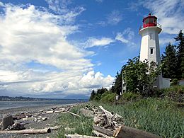
Cape Mudge Lighthouse on Quadra Island
|
|

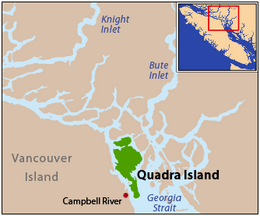
Quadra Island is located at the northern end of the Strait of Georgia
|
|
| Geography | |
|---|---|
| Location | Salish Sea |
| Coordinates | 50°10′N 125°14′W / 50.167°N 125.233°W |
| Archipelago | Discovery Islands |
| Area | 310 km2 (120 sq mi) |
| Highest elevation | 620 m (2,030 ft) |
| Highest point | Mount Seymour |
| Administration | |
| Province | British Columbia |
| Regional district | Strathcona |
| Demographics | |
| Population | 2,472 (2006) |
| Ethnic groups | Laich-kwil-tach |
Quadra Island is a large island located off the eastern coast of Vancouver Island in British Columbia, Canada. It is part of a group of islands called the Discovery Islands. The island is known for its beautiful nature, including many beaches, trails, and lakes.
Contents
Island Name: Where Did It Come From?
In 1903, Quadra Island was named after a Spanish explorer named Juan Francisco de la Bodega y Quadra. He explored the Vancouver Island area in the late 1700s.
Quadra Island's Past: A Brief History
In the 1700s, the Spanish explorer Juan Francisco de la Bodega y Quadra claimed the island for Spain. For a while, both Britain and Spain disagreed over who owned the island. This disagreement almost led to a war, known as the Nootka Crisis.
Luckily, they avoided a war! In 1790, they signed an agreement called the first Nootka Convention. This was the first step towards peace. Later, in 1793 and 1794, they signed more agreements. Spain then removed its fort from Vancouver Island. Both countries agreed not to build permanent settlements in the area. They also agreed to share trading and shipping rights.
In 1846, Britain and the United States signed the Oregon Treaty. This treaty decided the border for the U.S. Oregon Territory. To make sure Britain kept all of Vancouver Island and the nearby Gulf Islands, the border was drawn to go around that area.
First Peoples of Quadra Island
When Captain George Vancouver visited in 1792, the Coast Salish people lived on Quadra Island. He wrote about their village at Cape Mudge, describing their long houses, boats, and about 300 people.
Later, in the late 1800s, other First Nations groups came to the island. The We-Wai-Kai people, who are part of the Kwakwaka’wakw, took over the island. They did this through a mix of warfare and marriages between groups. The We-Wai-Kai people were skilled salmon fishers.
Today, the We-Wai-Kai band of the Kwagiulth still lives in Cape Mudge. For a long time, the government made it hard for them. They couldn't buy alcohol or join the modern fishing fleet until 1926. Even their special ceremonies, called potlatches, were made illegal. In 1922, after many arrests, the We-Wai-Kai people had to give up their masks and ceremonial items to the government. It took about 50 years for these important items to be returned to them at the Nuuyumbalees Cultural Centre.
Early Life and Development
The Kwagiulth people built the first school at Cape Mudge in 1893. The fishing industry that started then is still important today. A mine called the Lucky Jim, which dug for copper and gold, opened in 1903. However, it was destroyed by fire in 1941.
By 1904, Quadra Island had two post offices, a school, a hotel, and places for logging and milling wood. Fires caused a lot of damage over the years, making the economy difficult until the 1930s. A passenger ferry started in 1949, and a ferry for vehicles began in 1960.
Island Geography: What Quadra Looks Like
Quadra Island is separated from Vancouver Island by a narrow waterway called Discovery Passage. It's also separated from Cortes Island by Read Island and the Sutil Channel. A ferry connects Quadra Island to Cortes Island from Heriot Bay on its eastern side.
The island has many beautiful spots, including beaches, hiking trails, lakes, and parks. Main Lake Provincial Park is in the northern part of the island. Rebecca Spit Marine Provincial Park is on the eastern shore, close to Heriot Bay.
Quadra Island is about 35 kilometres (22 miles) long from north to south. At its narrowest point, it's less than 2 km (1.24 mi) wide. At its widest, it's about 15 km (9 mi) wide. With an area of 310 square kilometres (120 square miles), Quadra Island is the largest of the Discovery Islands. It's also the second largest island in the Salish Sea, after Whidbey Island in Washington.
Island People: Who Lives Here?
In 2006, about 2,472 people lived on Quadra Island. A more recent report from 2017 estimates the population is around 4,000 people. Most residents live at the southern end of the island. Many people on Quadra Island work in arts, fishing, logging, and tourism.
The Cape Mudge Reserve is located at the southern tip of the island. It is home to the We-wai-kai people. They are one of the main groups of the Southern Kwakiutl. Together with the We-wai-kum people, they are known as the Laich-kwil-tach.
Learning on the Island: Education
Quadra Island has an elementary school for younger students. Older students, from grades 6 to 12, travel by ferry to Campbell River. There, they attend École Phoenix Middle School or Carihi Secondary School. These schools are part of the local school district.
Island Culture: Art and Heritage
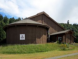
The Nuyumabalees Cultural Centre is located in the Cape Mudge Village. It opened in 1987 to house the Sacred Potlatch Collection. These are important cultural items that were returned by the Canadian government. The Centre continues to search for and bring back other potlatch artifacts from around the world.
The Southern Kwakiutl people moved into the northern Georgia Strait area over 200 years ago. They are part of the larger Kwakwaka'wakw group. They settled in this area, which was once home to the Comox and Pentlatch peoples.
Today, the We Wai Kai band of the Laichwiltach People are successful. They are involved in several businesses in nearby Campbell River and on Quadra Island. They even run a full-service resort called Tsa-Kwa-Luten Lodge & RV Park. The island's main commercial area is Quathiaski Cove, and Heriot Bay is another pretty community.
Getting Around: Transportation
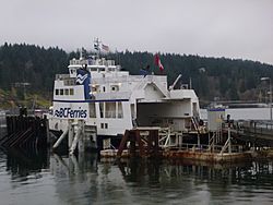
The BC Ferry terminal is at Quathiaski Cove on Quadra Island. This ferry connects the island to Campbell River on Vancouver Island. The ferry makes 18 trips each day. You can also find taxi services on the island. If you're flying, flights from Vancouver land at Campbell River and District Airport (YBL).
While many services are in Campbell River, Quadra Island also has a lot to offer. You can find a bank, ATMs, places to fix cars and boats, a gas station, cafes, restaurants, a library, a medical clinic, a pharmacy, and grocery stores. There's also an elementary school, childcare, police services, real estate agents, a hardware store, and adventure tour operators.
Famous People from Quadra Island
- Hilary Stewart was a writer who lived on the island for 35 years. She wrote about the local history.
- Ryan Guldemond is a musician and the lead singer of the indie rock band Mother Mother.
- Jan Zwicky is a philosopher and poet.
- Robert Bringhurst is a poet, typographer, and linguist.
See also
 In Spanish: Isla Quadra para niños
 | James Van Der Zee |
 | Alma Thomas |
 | Ellis Wilson |
 | Margaret Taylor-Burroughs |


