
Vancouver Island facts for kids

Vancouver Island is a large island located in British Columbia, Canada. It covers about 31,285 square kilometres (12,079 sq mi) of land. This makes it a very big island! It sits in the southwestern part of the province.
Long ago, before people from Europe arrived, three main groups of Indigenous people lived here. These were the Nuu-chah-nulth, the Salish, and the Kwakiutl people. Today, over 700,000 people call Vancouver Island home.
There are no bridges or tunnels connecting Vancouver Island to the mainland of Canada. Instead, people travel by ferry. These ferries carry both people and cars. One popular ferry route crosses the Strait of Georgia. It goes to the Tsawwassen peninsula, which has roads leading to Vancouver and other cities. This route is part of the Trans-Canada Highway. Another ferry route crosses the Strait of Juan de Fuca. This one goes to Anacortes in the U.S. state of Washington. From there, roads connect to cities like Seattle along the West Coast.
Cities and Towns on Vancouver Island
Vancouver Island is home to many interesting cities and towns. The largest city is Victoria. It is the capital of British Columbia. This means it's where the government of the province meets. You can find the Legislative Assembly building and the University of Victoria here.
Other places where people live on Vancouver Island include:
- Lake Cowichan
- Nanaimo
- Courtenay
- Comox
- Duncan
- Crofton
- Port Alberni
- Ladysmith
- Chemainus
- Port Hardy
- Parksville
- Cumberland
- Tofino
- Uclulet
- Colwood
- Sidney
- Qualicum Beach
- Coombs
- Port McNeill
- Campbell River
Images for kids
-
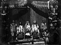
A Kwakwakaʼwakw wedding ceremony in 1914
-
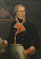
Dionisio Alcalá Galiano was the first European to sail all the way around Vancouver Island.
-
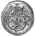
The Great Seal of the Island of Vancouver and its Dependencies was designed around 1849. It was the basis for the flag of Vancouver Island, which is still flown today.
-
The middle of Vancouver Island has high mountains, like Golden Hinde.
-
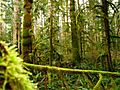
The western side of Vancouver Island has a beautiful rainforest.
-
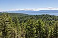
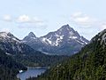
A view from Mount Maguire looking towards Washington.
-
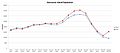
Vancouver Island population based on gender.
-
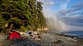
A campsite at Mystic Beach.
-
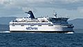
The BC Ferries MV Spirit of Vancouver Island, traveling from Swartz Bay to Tsawwassen.


See also
 In Spanish: Isla de Vancouver para niños
