Strathcona Regional District facts for kids
Quick facts for kids
Strathcona
|
||
|---|---|---|
|
Regional district
|
||
| Strathcona Regional District | ||

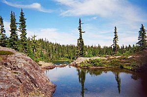
Strathcona Provincial Park
|
||
|
||

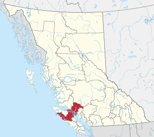
Location in British Columbia
|
||
| Country | Canada | |
| Province | British Columbia | |
| Administrative office location | Campbell River | |
| Government | ||
| • Type | Regional district | |
| • Body | Board of Directors | |
| Area | ||
| • Land | 18,278.06 km2 (7,057.20 sq mi) | |
| Population
(2016)
|
||
| • Total | 44,671 | |
| • Density | 2.44/km2 (6.3/sq mi) | |
| Website | srd.ca | |
The Strathcona Regional District is a special area in British Columbia, Canada. It's like a local government that manages services for several communities. It was created on February 15, 2008.
This regional district was formed from parts of an older one called the Regional District of Comox-Strathcona. Strathcona kept most of the land, about 91.6 percent, but only 42.1 percent of the people from the old district.
Today, the Strathcona Regional District covers a land area of about 18,329.948 square kilometers (7,077.232 sq mi). In 2016, about 44,671 people lived here. There are also 21 Indian reserves within its borders. These reserves had a population of 1,579 people in 2016. Their total land area is about 16.444 square kilometers (6.345 sq mi).
Contents
How Strathcona Regional District is Governed
The main office for the Strathcona Regional District is in Campbell River, British Columbia. At first, another district helped manage things. But now, Strathcona handles its own administration.
Who Leads the Regional District?
The district is led by a group called the Board of Directors. This board includes people who represent the different towns and areas within Strathcona. There are five municipalities (cities or villages) and four electoral areas.
In the future, leaders from some of the First Nations governments might also join the board. This would happen after special agreements, called treaty settlements, are made.
Where is Strathcona Regional District Located?
Most of the Discovery Islands are part of the Strathcona Regional District. These islands are beautiful places with lots of nature. A few of the islands further south belong to the Powell River Regional District.
Communities in Strathcona Regional District
The Strathcona Regional District includes several towns and villages. These are called municipalities.
| Municipality | Type of Government | Population (2016) |
| Campbell River | city | 32,588 |
| Gold River | village | 1,212 |
| Sayward | village | 311 |
| Tahsis | village | 248 |
| Zeballos | village | 107 |
Electoral Areas and Smaller Communities
Besides the main towns, there are also "electoral areas." These are parts of the district that don't have their own city or village government. They include smaller, unincorporated communities.
- Area A (Kyuquot/Nootka–Sayward)
- Area B (Cortes Island)
- Cortes Bay
- Mansons Landing
- Squirrel Cove
- Whaletown
- Area C (Discovery Islands–Mainland Inlets)
- Heriot Bay
- Port Neville
- Quathiaski Cove
- Refuge Cove
- Area D (Oyster Bay–Buttle Lake)
- Oyster Bay
 | Georgia Louise Harris Brown |
 | Julian Abele |
 | Norma Merrick Sklarek |
 | William Sidney Pittman |


